
Sima............................................................................................................................................................................................................................................................................Sima
Sima / Sima / Sima (geologische) / 司马(地质) / Сима (силикатная оболочка) / Sima (livello geologico) /
General term for the rocks rich in magnesium (basalt, gabbros, peridotites, etc.) outcropping in the ocean basins, which constitute the lower part of the continental crust and the mantle. The sial/sima limit corresponds to the Conrad's discontinuity (mean density ≥ 2,800 kg / cm3).
See: « Sial »
&
« Hot Spot »
&
« Asthenosphere »
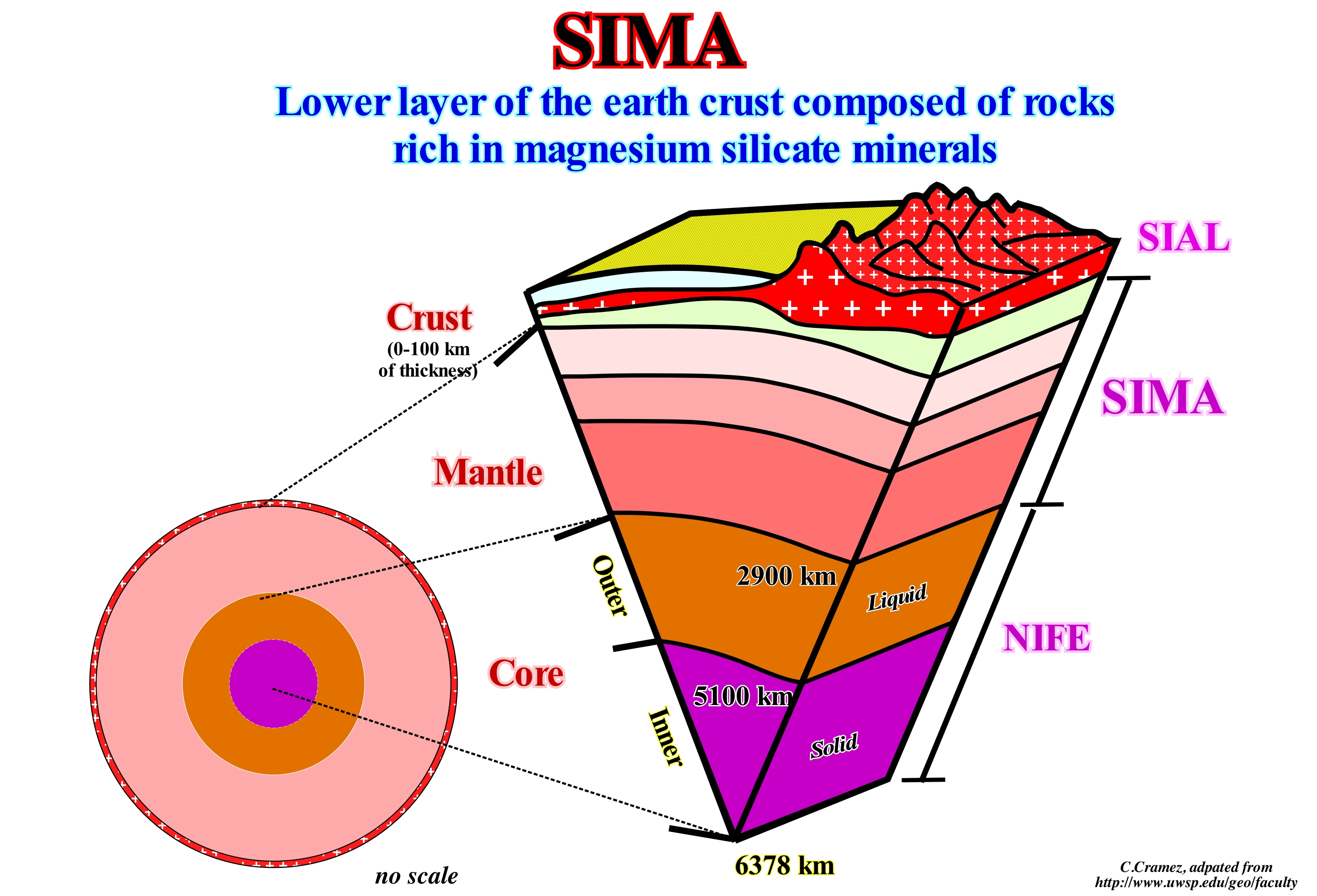
The sima is the name given to the lower level of the Earth crust, although, as illustrated above, it extends up to 2,900 km deep, that is, up to the upper limit of the Earth's core, which is called nife, since nickel is iron are its main components. The name sima derives from the first two letters of silica and magnesium. The sima is composed of rocks composed of minerals rich in silica and magnesium. Typically when the sima rises to the bottom of the sea, it is, basically, formed of basalts, which led many geoscientists to call it the basaltic level of the Earth crust. As the ocean bottoms are, fundamentally, made up of sima, certain geoscientists wrongly call it oceanic crust, since, as stated above, the sima extends to the Earth's core, that is, far beyond the crust oceanic The density of the sima is greater than that of the sial that is overlying it. The density of the sima varies between 2,800 and 3,300 kg/m3. When the sima appears on the surface, especially, on the sea floor, it is formed by mafic rocks or rocks rich in mafic minerals. The denser sima has less silica and forms the so-called ultramafic rocks. The sial has a density between 2,700 and 2,800 kg/m3, which is much lower than the sima density (2,800/3,300 kg/m3). At the base, the sial, progressively, passes to the basalts that form the sima. The line separating the sial from the sima is the Conrad discontinuity, which, arbitrarily, is placed when the average density reaches 2,800 kg/m3. The mean density of the sima varies between 2,800 and 3,300 kg/m3 in the upper part, and between 3,300 and 5,600 kg /m3 in the lower middle part. It can be said that from the point of view of chemical composition, the Earth divides into three layers: (i) Sial, a thin, fragile, superficial layer composed mainly of silica and aluminum ; (ii) Sima, intermediate layer, with a thickness of about 2,850 km, ductile, dense, composed mainly of silica and magnesium, and (iii) Nife, lower layer and more or less equivalent to the Earth's core.
Sinkhole......................................................................................................................................................................................................................................................Doline
Dolina / Dolina / Doline, Karsttrichter / 沉洞 / Карстовая воронка / Dolina, Lavello, Sinkhole /
Natural depression or hole in topographic surface caused by removal of soil or underlying rock or both by water. The sinkholes vary greatly in size (from a few centimeters to several hundred meters) and diameter,as well as in depth. The shape of sinkholes depends mainly on the structure of the soil and rocks in which they form.
See: « Cave (grotto) »
&
« Cave »
&
« Dissolution »
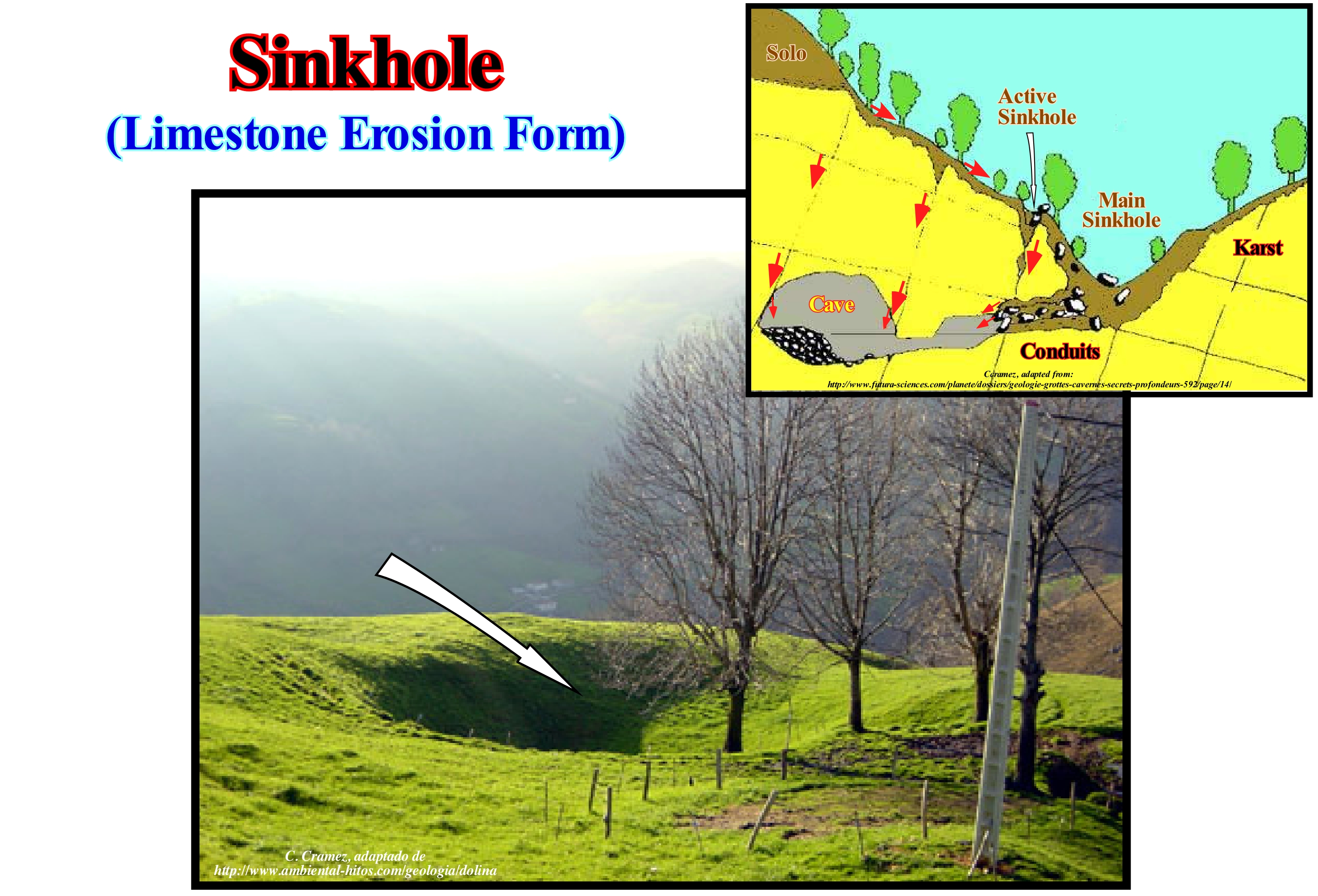
Several mechanisms of formation of a sinkhole are possible: (i) Gradual removal of the soluble parts of a rock (usually limestones) by infiltration of water ; (ii) Collapse of the roof of a cave ; (iii) Lowering of the water table (level at which water pressure equals atmospheric pressure), etc. Sometimes, under the opening of a sinkhole you can find a cave, and even rivers such as the Cedar sinkhole (National Park, USA). Sinkholes are often associated with karstic morphologies. In such regions, there may be hundreds or even thousands of sinkholes in relatively small areas such that the surface of the terrain is, totally, altered and no water stream is possible on the surface since all water flows in depth. Over time, the caves in the limestones increase in volume, the ceilings collapse forming sinkholes. These form very quickly and can have catastrophic consequences, destroying homes, cars, and other properties. Sinkholes are found very often in the Jura Mountains, as well as in Florida and, as illustrated in this photograph, also in the north of Spain. When the aquifers are shallow, sometimes, the sinkholes are filled with water and form lakes whose dimensions may be important. Unfortunately for centuries, sinkholes have been used to store garbage, which has, obviously, polluted groundwater and has very serious consequences for the health of the populations living in the affected regions. The sinkholes can be buried in the aquifer systems and fossilized by sediments, when the pressure of the aquifers helps to stabilize the sediment cover. However, if water is pumped for urban uses or irrigation, which often happens, the sinkholes reappear once the water table falls. The sinkholes that form on reefs and coral islands, which have great depths, are the "blue holes" of the divers.
Skerry................................................................................................................................................................................................................................................................Écueil
Escolho/ Escollo / Kippen / 寻找那个水下 / Риф (подводный камень) / Skerry, Scoglio, Scogliera /
Small rocky island, whose dimensions are too small for it to be inhabited (under normal conditions). This term is, also, used to designate a rock near the water surface that can, sometimes, correspond to the top of a reef.
See: « Pinnacle, Stack »
&
« Atoll »
&
« Rocky Islet »
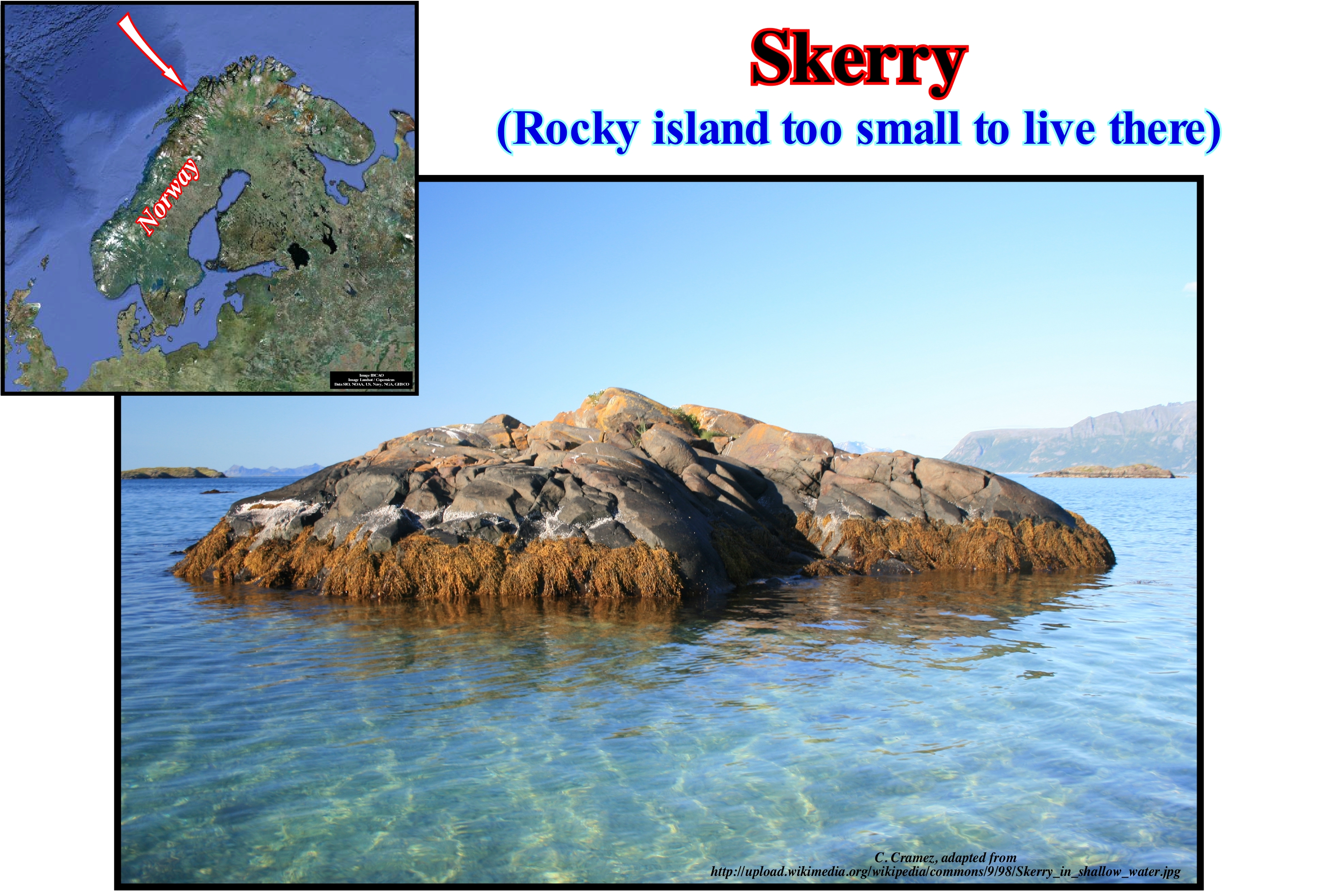
Skerries are very frequent at the exit of the fjords, where the submerged glacial valleys formed perpendicular to the shoreline join with other valleys in a complex matrix. In some places near the distal margins of the fjord areas, the channels carved by the ice are so numerous and in such varied directions that the rocky coastline is divided into many rocky islands called skerries. Some of these are of considerable size and mountainous, while others are small rocky points that make it difficult to navigate. Highstand geological conditions, that is, when the sea level is lower than the basin edge, which here, normally, corresponds to the continental edge favour the formation of skerries. However, a significant relative sea level fall exhumes the entire continental shelf, if the basin has a platform, and thus all the deposits disappear. The skerries appear during the transgressive interval (TI) and during the initial phase of development the highstand prograding wedge (HPW) level prisms, when the basin edge coincides with the continental edge. During transgressive interval, the basin edge (coincident with the continental edge) is seaward of the shoreline, whereas during the highstand prograding wedge, except in the initial phase of the development, the shoreline coincides with the continental edge, which is also the basin edge. Geoscientists consider the skerries, such as cliff tops, to the water's edge as obstacles or dangers to navigation, which is, slightly, different from the original definition. In English skerry, which is derived from the old Norwegian "sker" means a rock in the sea, whose dimensions do not allow the implantation of dwellings. The skerries that can be individualized on the offshore of Portugal (not far from the shoreline) have a completely different origin from those of the Nordic countries, whose origin is fundamentally glacial. The great majority of the skerries in Portugal and in particular those of the south offshore are the result of the marine erosion and mainly the consequence of the collapse of the natural arches.
Slab Pressure.......................................................................................................................................Pression de la plque descendante
Pressão da placa descendente / Presión de placa descendente / Druck der absteigenden Platte / 板块向下的压力 / Пластовое давление / Pressione della piastra verso il basso /
Descending plate pressure and ocean dorsal constraint are informal terms that have been used in the plate tectonics literature to designate the horizontal forces induced by the dip of a descending lithospheric plate along a subduction zone and by the difference in elevation between the expansion's center and the ocean floor.
See: « Ridge-Push »
&
« B-Type Subduction (Benioff) »
&
« Sea Floor Spreading (oceanic expansion) »
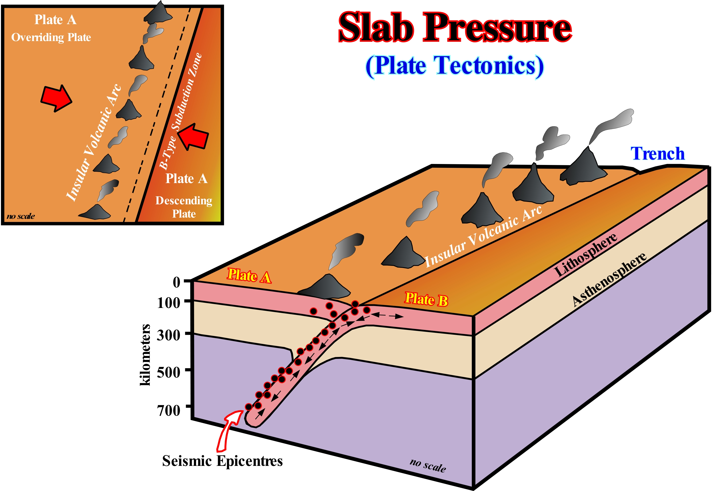
In a B-type or Benioff subduction zone (as opposed to the A-type or Ampferer subduction zone), since the oceanic plate dives, due to gravity and, certainly, to other causes not yet well known, the lithospheric material, cold, dense and brittle, comes in contact with material of the asthenosphere having a much higher temperature (about 1,250° C). The dip of the descending lithospheric plate in the subduction zone creates a, more or less, horizontal tectonic force along the plate. This force, which is, largely, a function of the subduction angle, pushes the descending plate against the overriding plate creating a deformation regime at the level of the lithosphere and, above all, in the overriding plate. Function of its thermal conductivity, as the lithospheric plate descends into the subduction zone, it will warm up. The temperature rise changes the rheology and a part of it is assimilated or forms a magma. The rise of this magma induces the appearance, on the overriding plate (oceanic or continental), of volcanoes, more or less, aligned parallel to the oceanic trench. These volcanoes form a volcanic arc at a distance from the trench, which is variable as a function of the angle of the subduction zone. Although the descending plate (subducting plate) is in a compressive state, there are, locally, lengthening sectors therein, in particular close to the inclination break. These extensional zones are corroborated by the study of earthquake epicentres, as suggested in the scheme illustrated in this figure. The subduction of the descending plate (cold, dense and fragile) into the asthenosphere modifies the position and the equidistance of the upper mantle isotherms, which may induce the formation of divergent convection currents. These currents, located under the overriding lithospheric plate are, probably, responsible for the lengthening of the continental crust of the overriding plate and thus of the formation, in the inner part, of backarc of rift-type basins.
Slide Mound (Slump mound).............................................................................................................................Monticule de glissement
Montículo de deslizamento / Montículo de deslizamiento / Slump Hügel / 滑塌丘 / Сдвиговый холм / Monticello di scivolamento /
A mound-shaped structure on a geological section or seismic line located in a sliding context and in which the internal configuration of the associated bedding planes or reflectors have a collapsing geometry.
See: « Mound Reflection Configuration »
&
« Stratal Patterns »
&
« Complex Mound »
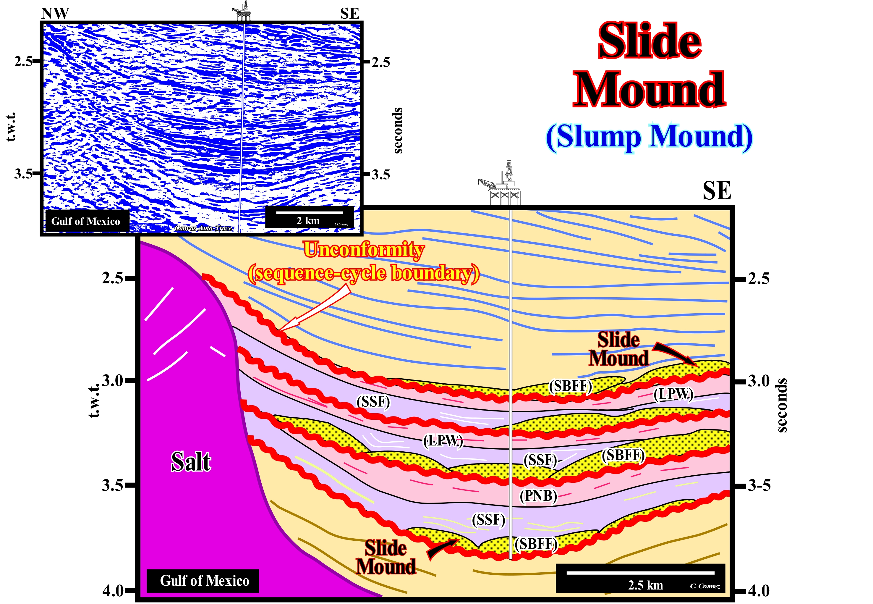
On this tentative geological interpretation of a Canvas auto-trace of detail of a Gulf of Mexico in seismic, where saliferous structures are frequent, a series of sliding mounds can be observed, in particular, in the so-called "minibasins", which are almost always surrounded by salt domes. The salt dome, which form due to the relative buoyancy of the salt when buried beneath other types of rocks, are mushroom-shaped rather than cylindrical-shaped structures, as many think (cylindrical shape is physical impossibility, since salt density is constant in depth, which is not the case for sediments), which have, generally, an overlying sealing rock. As can be seen from this tentative interpretation, these anomalies fossilize, partially, the lower limits of the sequence-cycles, that is, the deep-water correlative paraconformity of the unconformity visible upstream. These unconformities are, generally, readily recognized by the lapouts of the underlying and overlying reflectors, but also by the presence of submarine canyon fillings and incised valley fillings. Probably, the sliding mounds on this tentative interpretation correspond to submarine basin floor fans (SBFF) deposited in small basins created by the compensatory subsidence that accompanies the total or partial expulsion of the salt from the underlying salt horizon. These small basins are, generally, surrounded on all sides by either salt domes or salt walls (elongated, discordant diapiric salt structures, which form, generally, sinuous, more or less, parallel alignments). If the salt of the central part of a large and thick saliferous horizon, such as a salt mantle, begins to flow laterally, a great depression forms in the suprasalt sediments. It is in this type of depressions or basins of this type (denominated expulsion salt basins or evacuation salt basins), that form the slump anomalies illustrated on this tentative. In terms of sequential stratigraphy, it can be said that these anomalies may be associated with falls of the relative sea level (local sea level, referenced to base of the sediments or to the sea floor) induced by the combined action of absolute (eustatic) sea level (supposed global and referenced to the Earth's centre of the Earth) and by the diapiric uplift of certain parts of the salt horizon (P. Vail's turbidite depositional model). Although, the turbidite currents induced by slumps and instability failures developed under highstand geological conditions (E. Mutti's turbidite depositional model) can not be excluded. It is possible the vertical and upward movements induced by the diapirism* of deeper rocks have destabilized the sediments of the salt expulsion basins, and that the sediments have slipped, by turbidity currents, to the central part of the basin. In this example, the sequence-cycles, delimited between the red horizons (sequence boundaries that may be unconformities or correlative deep-water paraconformities), are incomplete. Highstand systems tracts groups (HSTG) were not deposited. The transgressive intervals (TI) and the highstand prograding wedges (HPW) are absent. Only the sediments of the lowstand systems tracts group (LSTG) were deposited. However, the three lowstand sub-groups are all represented. From bottom to top are recognized: (i) Submarine Basin Floor Fans (SBFF) ; (ii) Submarine Slope Fans (SSF) and (iii) Lowstand Prograding Wedge (LPW). The submarine basin floor fans (SBFF), coloured in khaki, have a mound configuration. The submarine slope fans (SSF), coloured in violet, have a wavy configuration with a "gull-wings" geometry (a central depression flanked by two fusiform bodies). The lowstand prograding wedge (LPW), coloured in pink, has an apparent parallel configuration, since, on perpendicular seismic lines, the internal configuration is progradational. In certain cases, due to salt conditions, in this type of basin, sliding mounds may also be associated with submarine slope fans (SSF).
(*) Diapirism, broad sense, is a geological process by which a deep igneous or sedimentary material, for various reasons, perforates or attempts to pierce overlying sedimentary layers.
Slikke (Mud-flat)................................................................................................................................................................................................Vasière mole (Marée basse)
Vasa mole (baixamar) / Llanura fangosa / Schlick / 滩涂痣 / Ил, покрывающий эстуарии при отливе / Pianura fangosa mole /
Mud deposited on the platform of low tide, consisting of fine fluvial and marine sediments, which is covered at each tide. The vegetation is almost absent, but the biological productivity is very intense.
See: «Tidal Flat »
&
« Schorre »
&
« Tide »
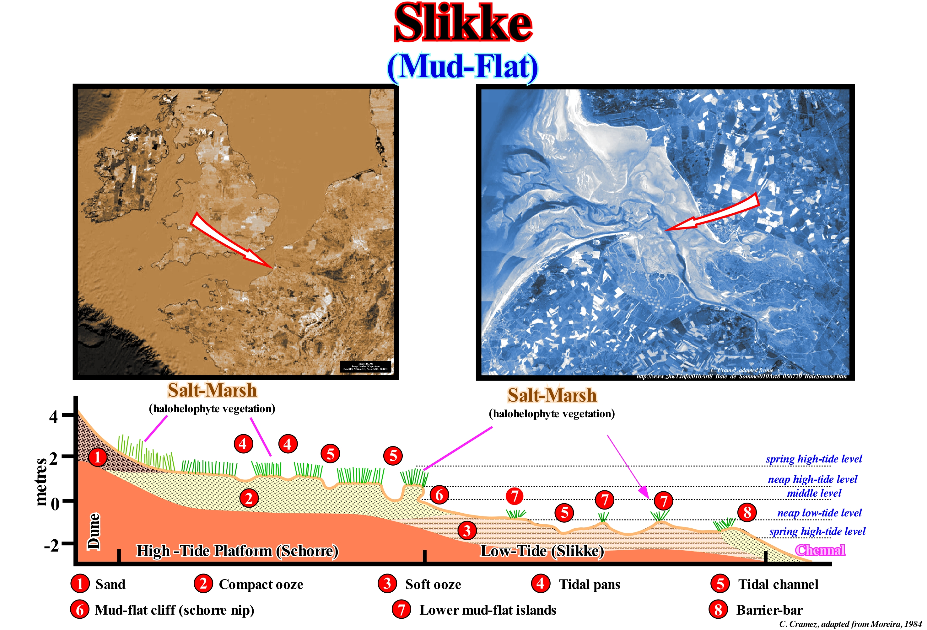
A few years ago, marshes and mudflats (compact and soft), such as those of Somem estuary (France), illustrated in this figure discourage tourists because of their landscape was considered hostile and uninteresting. At present, awareness of the ecological importance of wetlands has, significantly, altered the perception of so-called captivating landscapes. In the slikke sketch shown in this figure, one can recognize: (i) Sand ; (ii) Compacted ooze; (iii) Soft Ooze ; (iv) Tidal Pans ; (v) Tidal channels ; (vi) Mud-Flat Cliffs ; (vii) Lower Mud-Flat Islands (marshes) and (viii) Barrier-Bars. The compacted ooze of the schorre (upper marsh), which is submerged just during spring high-tides, is individualized from the soft ooze of the slikke (lower marsh) by the mud-flat cliff (schorre nip). As illustrated, the slikke emerges only during spring low-tides. Do not forget that the low-tide is the minimum level of water at the end of the ebb, when the current is kept still and that in semi-diurnal tides (when there are two low-tides in the same day) to the lower one is called lower tide as opposed to the one of greater height, which is upper low-tide. On the other hand the spring low-tide, is the low tide that occurs near the equinoxes. On the other hand, the high-tide marks the maximum level of a full tide and the spring high-tide the high-tide occurring during the equinoxes. The soft ooze has little vegetation, but has a huge bacterial biomass that plays a fundamental role in the processes of auto-depuration and recycling of dead organisms. It houses a wide variety of bivalve species (clams, cockles, etc.), small grass gastropods, green crabs, herbivorous fish and hunters (mules, plaice, snapper, etc.). Worms and molluscs that live in the salt water are the preferred food of many birds.
Slope (Talus, taluvium).............................................................................................................................................................................................Talus (Taluvion)
Talude, Taluvium / Talud, Taluvium / Hang , Taluvium (gefördert durch die Massenbewegung) / 坡 / Склон, Отвалочный материал / Pendenza, Taluvium (trasportati dal movimento di massa) /
Dipping deposit built by the accumulation of rock debris at the foot of a cliff or ridge.
See: « Alluvial »
&
« Promontory »
&
« Continental Slope »
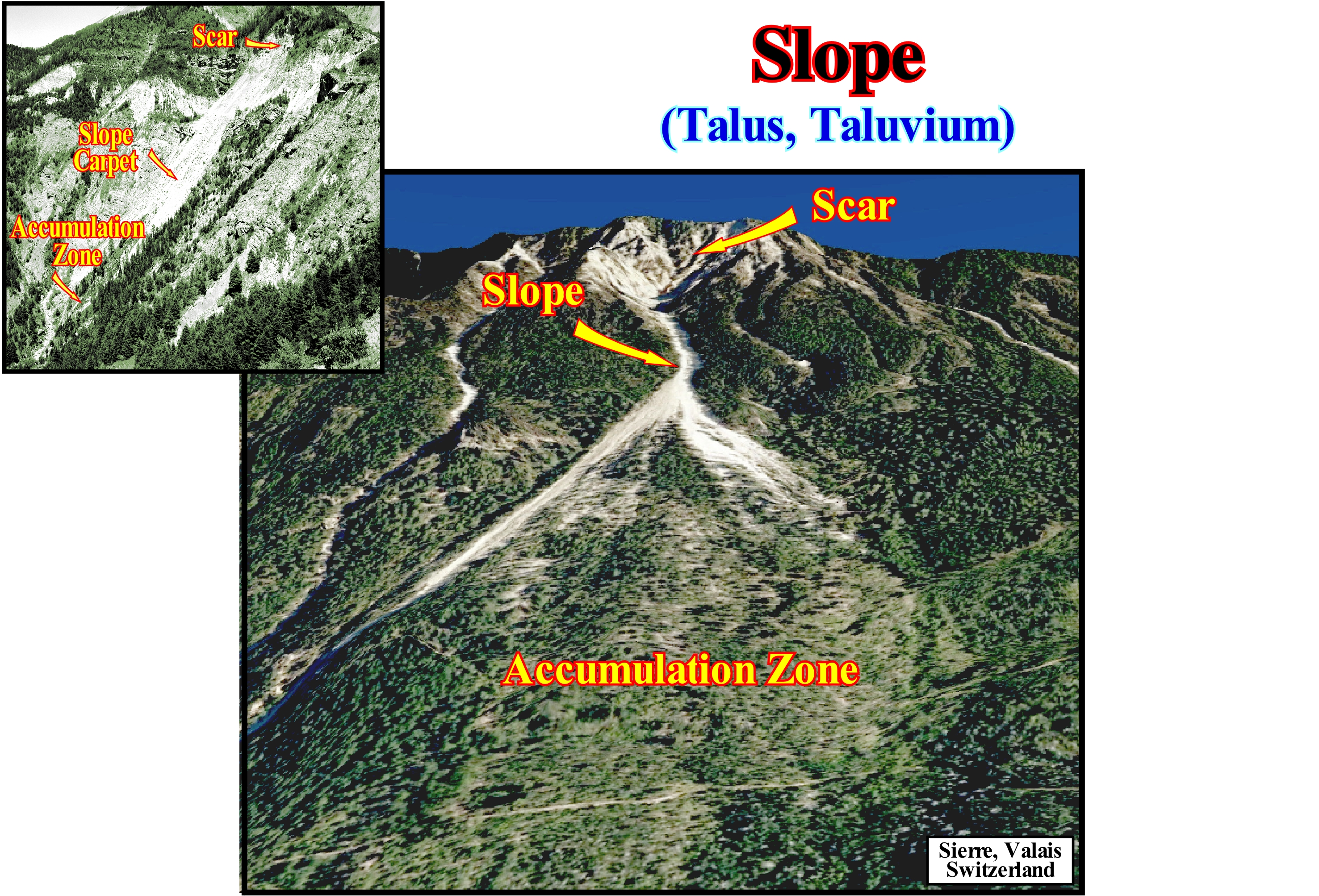
The smaller picture, taken in the French Alps, confirms the conjecture advanced by many geoscientists that a large part of the slopes are made up of a mixture of, relatively, large rock fragments and much finer sedimentary material, which certain geoscientists call taluvium. In this particular case, the rock fragments show a convergence to the base slope along gutters or drains that, deeply, furrowed the rocks (in this case limestone), which form the mountain slope. Sedimentary particles and rock fragments are, largely, transported by water, both during periods of heavy rainfall and during snow melting, when water flows along the slopes is frequent. In this image (Digne's Tableau in the French Alps, http://www.lmgc.univ-montp2.fr/MIDI/gal_alfredo/main2.html), it is important to note the uniform slope constructed by the granular deposits whose dip is close to the internal friction angle of the granular material (when wet). The main morphological characteristics of this slope type are: (i) The scar (upper arrow), which is the upper area where failure began and is the source of almost all sedimentary particles ; (ii) The carpet or slope, which is a long and relatively narrow row formed of rock debris in direction of the slope base (middle arrow) and (iii) The accumulation zone, which is located at the base of the slope and which is, more or less, connected with a secondary drainage channel. As can be seen also in this photograph: (a) The slides and flow of the material prevent the growth of vegetation along the slope ; (b) Limestone blocks, which are more resistant to erosion than shales or conglomerates, stabilize the overlying rocks constituting an obstacle to the sliding of material from the top of the slope, i.e., from the scar and (c) The active slope, which is located along a track, where the limestone blocks have been eroded or are missing. The rest angle of the rock particles and fragments, which make up the slope, corresponds to the maximum dip angle that the slope can have. In general, it is about 30° and, as stated before, this angle is, more or less, constant along the carpet of taluvium (or talus). Similarly, on the northern slopes of the Valais Alps (Rhone valley, not far from the town of Sierre, in Switzerland) the three zones that make up an alluvial or dejection fan (alluvial fan, i.e., deposit of detrital material, poorly selected and poorly worked, which forms at the foot of the mountains where the thalweg of the valleys find a flatter area), that is to say, the scar, the slope and the zone of accumulation are, easily, recognized. A huge debris flow activity occurs in the fans of the accumulation zones. Thus, for instance in the famous Loesch slope, in the Swiss Alps, not far from the fan illustrated in this figure, geoscientists* were able to evaluate the activity of the debris flows from the study of growth ring disturbances ** of centenary trees, which provide a complete record of past geological events and deposition phases in the accumulation zone. In fact they studied about 2,200 samples of tree growth rings, mainly Larix decidua Mill., Picea abies (L.) Karst and Pinus cembra asp., which allowed the reconstruction of 123 events since the sixteenth century (more or less, since 1566). The geomorphic mapping allowed the identification of 769 events related to old debris flow in the intermediate fan. Inventoried geological events (in an area of about 32 hectares) include 291 fans, 465 natural marginal dykes (levees) and 13 debris flow channels fills. At the base of more or less disturbed growth ring records, almost 86% of the fans identified on the current surface could be dated. Most of the dated material was deposited during the 20th century. Signs of events prior to the 20th century are often recognized in the surviving growth rings, but the material that caused the growth anomaly in trees has been completely replaced or eroded by more recent debris flow activity.
(*) M. Stoffel, et al., 2008 - Unravelling the patterns of late Holocene debris-flow activity on a cone in the Swiss Alps: Chronology, environment and implications for the future, Global and Planetary Change 60 , pp. 222 – 234.
(**) Let us remember that the scientific method of establishing the age of a tree, based on the patterns of its trunk rings, is dendrochronology, which was invented and developed by A. E. Douglass, founder of the Tree-Ring Research laboratory at the University of Arizona.
Slope Angle (Carbonates & siliciclastics).................................................................................................................................Angle de Talus
Ângulo do talude / Ángulo de talud / Böschungswinkel / 大陆坡角 / Угол наклона / Angolo della scarpata continentale
Slope of depositional surface between depositional coastal break and bottom slope break in both carbonates and siliciclastics. The slope angle marks the seaward displacement either of the shoreline (delta progradations) or the continental edge, which coincide, more or less, when the basin has no shelf (during the lowstand prograding wedge, LPW, and during the 2nd phase of development of the highstand prograding wedge, HP,, of a sequence-cycle). In siliciclastic intervals, the slope angle of the delta and continental slope, is smaller than in the carbonate intervals, which in the latter case can reach values between 20° - 30°. That is why the identification, on the seismic lines, of deltaprocesses are much more difficult than the identification of the carbonate, particularly reefs.
See: « Progradation »
&
« Downlap »
&
« Reef »
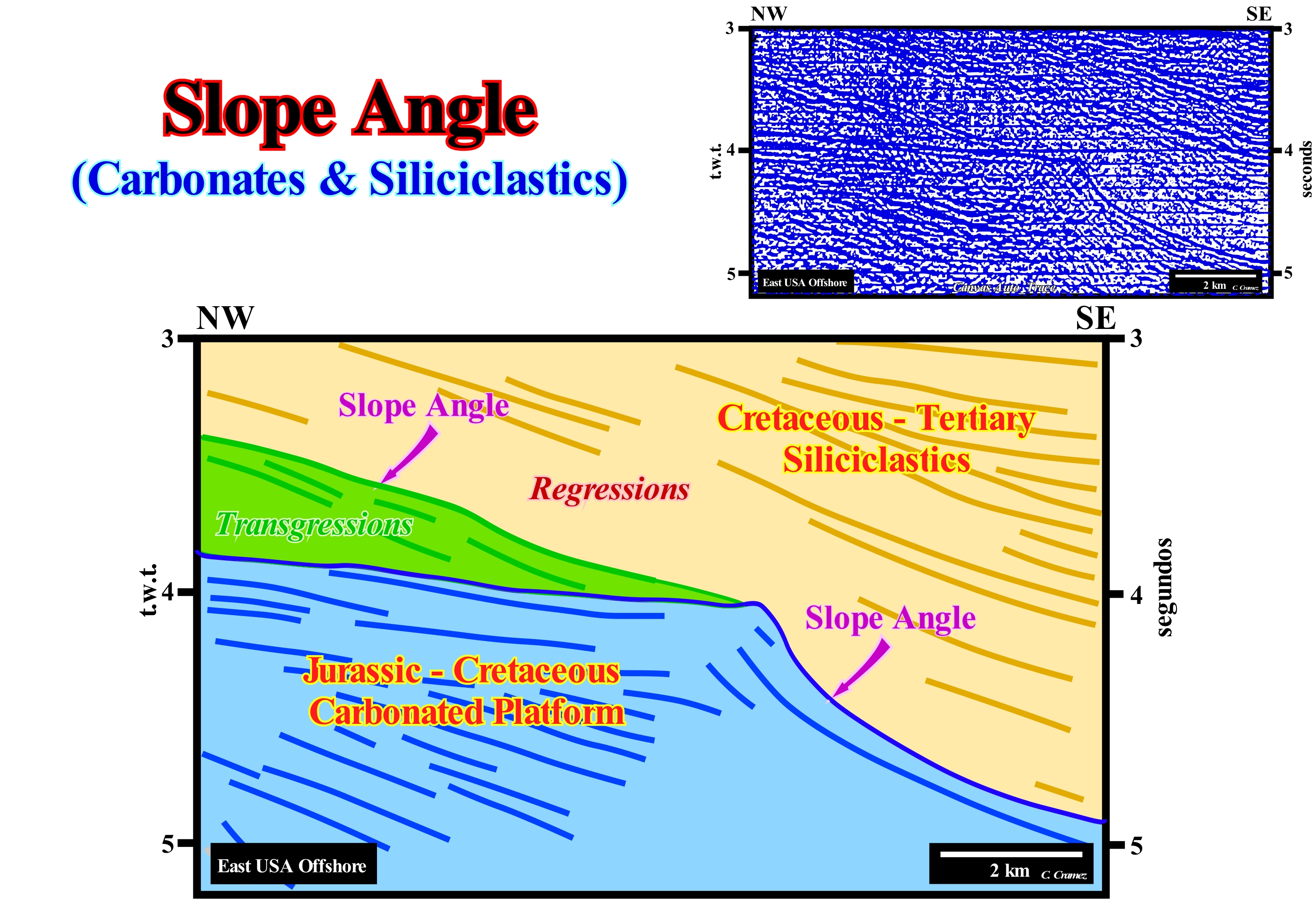
As illustrated on this tentative geological interpretation of a Canvas auto-trace of a detail of an East USA offshore seismic line, the thickness of the Wilmington carbonate platform (Jurassic-Cretaceous carbonate platform) is, on the South flank, greater than 2,500 meters. The slope of the platform's internal reflectors (chronostratigraphic lines, i.e., timelines) along which various slope breaks of the depositional surface can be brought into evidence (bayline break, coastal break, continental break, etc.) underlines the temporal evolution of the carbonated continental slope. As can be seen on this tentative interpretation, most likely, during Late Cretaceous, the carbonate platform was fossilized by siliciclastic deposits that prograde seaward with a lower repose angle than the angle of carbonated slope progradations. Theoretically carbonate material supports a much greater angle of repose than the siliciclastic material. This fossilization may have taken place as follows: (i) During the Late Cretaceous, the carbonate platform was submerged and drowned by a marine ingression that placed it underneath the photic zone (zone with sunlight that allows photosynthesis), which, naturally, prevented the formation of carbonate ; (ii) This first marine ingression (greater than the previous one) shifted the shoreline continentward, was followed by increasingly important marine ingressions that form what geoscientists call a complete marine ingression* ; (iii) Marine ingressions (increments to a complete ingression) are separated by stability periods of relative sea level, during which deposition resumes ; (iv) Each increment of relative sea level rise (marine ingression) forced the depositional coastal break of the depositional surface (more or less, the shoreline, especially, on the seismic lines) to move tens of kilometers continentward (north-western), creating, in the pre-existing topography (deposited sediments), a ravinment surface ; (v) During stability periods of relative sea level, which separate the marine ingressions, the deposition resumed and the shoreline, gradually, moved seaward (progradation), as the sediments deposited to form sequence-paracycles with onlaps upstream and downlaps seaward ; (vi) Collectively, the displacement of coastal onlaps continentward, after each marine ingression, has created not only a geometry, globally, retrogradational (green interval), but also starved geological conditions on the distal part of the continental shelf, that is to say, that it created geological conditions with a very low sedimentation rate. It was to this set of increasingly important marine ingressions and increasingly smaller sedimentary regressions that C. Emiliani, in 1991, collectively called transgressions (not transgression) ; (vii) Later, during the deposition of the orange interval (probably an highstand prograding wedge), the relative sea level continued to rise, but in deceleration (increasingly smaller marine ingressions with associated increasingly important sedimentary regressions), which allowed, in a more or less continuous way, the progradation of the depositional coastal break of the depositional surface seaward ; (viii) Cretaceous - Tertiary siliciclastic progradations, gradually, reduced the continental shelf dimensions (carbonate platform) until the shoreline (depositional coastal break of the depositional surface) coincided with the continental edge ; (ix) From that moment, the entire carbonate platform was fossilized and lost its continental shelf (no shelf). It can be said that from that moment the shoreline (more or less, the depositional coastal break of the depositional surface), the continental edge and the basin edge are coincident (basin without shelf). Obviously, in this tentative interpretation, which was not done at the hierarchical level of the sequence-cycles, several unconformities (erosional surfaces) can be evidenced by the geometrical relations between the reflectors (onlaps and toplaps) within the seismic intervals considered and, mainly, within the blue and orange coloured intervals.
(*) A complete marine ingression is the set of increasingly marine ingressions (increments of the complete marine ingression) without relative sea level falls between them.
Slope Deposit (Apron)..................................................................................................................................................Tablier, Dépôt de talus
Depósito de talude (apron, avental) / Apron, Depósito de talud / Schürze (Geologie), Slope Anzahlung / 围裙(地质), 边坡存款 / Фартук (геология), Отложения на склоне / Apron (geologia), Deposito di pendenza, Deposito di versante /
In general, slope deposits include all sediments deposited on the continental slope: (i) Submarine slope fans (SSF) ; (ii) Progradational sediments of the lowstand prograding wedge (LPW) ; (iii) Progradational sediments of the highstand prograding wedge (HPW). In a restricted way, are the clay deposits at the base of the submarine slope fans (SSF). The toverbank deposits, the filling deposits and the natural levees are deposited on the apron deposits, which in some cases are deposited directly on the usubmarine basin floor fans cones (SBFF). Synonyms of Apron.
See: « Submarine Slope Fan »
&
« Submarine Basin Floor Fan »
&
« Apron »
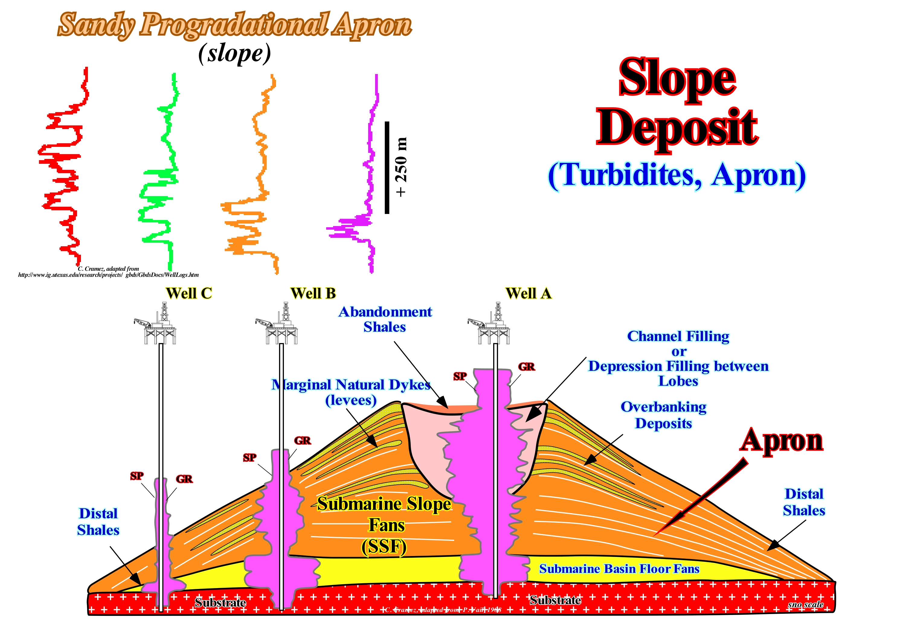
In this sketch are represented the turbidite systems associated with a significant relative sea level fall, that put the sea level lower than the basin edge or than the depositional coastal break of the depositional surface (continental edge), when the basin has no shelf. These turbidite systems are associated with unconformities (erosional surfaces) and are deposited during lowstand geological periods, which is not the case for certain turbidite deposits of E. Mutti (1995), which settle when sea level is higher than the basin edge. In the depositional turbidites model of Peter Vail, the submarine basin floor fans (SBFF) and the submarine slope fans (SSF) are the only subgroups of sedimentary systems tracts that are deposited during falls of the relative sea level*. All other sub-groups of sedimentary systems tracts that constitute a sequence-cycle, i.e. the lowstand prograding wedge (LPW), the transgressive interval (TI), and the highstand prograding wedge (HPW) are deposited when the relative sea level rise, since the sediments that compose them need accretion or an increasing of available space for sediments (accommodation) to deposit. In this scheme, at the level of a sequence-cycle, above the substrate (sediments of an underlying cycle-sequence or above the basement), in the abyssal plain of the basin, submarine basin floor fans (SBFF) were deposited, which emphasize, with a minimum error, the age of unconformity that limits at base the new sequence-cycle. The submarine slope fans (SSF), whose upper and lower limits are abrupt, deposit, more or less, horizontally. They have a planar shape when the dimensions are significant and, more or less, mounded when the extent is smaller. On the other hand, its internal configuration is parallel. Overlying the submarine basin floor fans (SBFF), in general, the submarine conglomerate cones (SBFF), are deposited the submarine slope fans (SSF), whose wavy geometry, with downlaps with opposite vergences (gull wing structures), are characteristic. Sometimes, the submarine basin floor fans may be disconnected from the base of the continental slope and, in this case, they are, rarely, covered by the submarine slope fans. As illustrated in this geological sketch, each submarine slope fan (SSF) is composed of several sedimentary bodies: (i) Slope deposits, which form the apron or the base of the fan ; (ii) Overbank Deposits, which between them define a depression, generally called, in a wrong way, a channel, along which the streams flow ; (iii) Filling deposits that fossilize the depression between the turbiditic natural marginal dikes (levees) ; (iv) Turbiditic Natural Marginal Dykes (levees), which in the proximal parts have a sandy facies ; (v) Distal Shaly rocks and (vi) Abandonment Shales, which are deposited in the upper part of the filling deposits. The morphology of the electrical logs of the turbidite deposits, whether they are basin or slope fans, is typical: a) The boundaries of the submarine basins floor fans (SBFF) exhibit an abrupt GR (gamma ray) and SP (spontaneous potential) giving a geometry, more or less, cylindrical for each set of turbidite basin floor fans ; b) The slope deposits has a SP and GR of low amplitude ; c) Overbanking deposits have a, more or less, oscillating SP and GR, that is to say, they are coarsening and thickening upward strata, at the bottom, and at the top, finning and thinning upward and and filling deposits have a SP and GR of finning and thinning upward strata, particularly when the facies are sandy. Assuming that exploration wells A, B, and C were drilled in the same submarine slope fans, the electric logs suggest a location that is difficult to refute. They clearly show that: (1) The sandstones that fill the depression between natural marginal dikes are the most likely potential reservoir-rocks ; (2) Te sandy intervals of the natural marginal dikes are thin and with limited extent (they may only be considered as additional reservoir-rocks) ; (3) Communication between potential reservoir-rocks, i.e., a filling of depressions or channels (in case of erosion) and turbiditic natural marginal dikes is unlikely, although possible.
(*) Local sea level, referenced to any point on the Earth's surface which may be the base of sediments or the sea floor and which is the result of the combined action of absolute (eustatic) sea level, which is supposed to be global and referenced to the Earth's centre and tectonics (subsidence or uplift of the sea floor).
Slope Fan (Submarine slope fan)......................................................................................................................Cône sous-marin de talus
Cone submarino de talude / Cono submarino de talud / Submarine Kegel Hang, Hang Fan / 潜艇锥坡 / Подводный конус выноса склона / Cono sottomarino di scarpata continentale /
Turbidite deposit, which within a sequence-cycle is located at the bottom of the continental slope over the submarine turbiditic fans and underneath the lowstand prograding wedge (in a complete sequence-cycle). The stacking,more or less, progradational several submarine slope fans form the subgroup of lowstand systems tracts, which geoscientists call submarine slope fans (SSF). Several depositional systems can be recognized in a submarine slope fan: (i) Apron ; (ii) Overbank deposits ; (iii) Filling of channels or submarine epressions ; (iv) Abandonment claystones ; (v) Pelagic Envelope and (vi) Natural levees, etc.
See: « Turbidite »
&
« Relative Sea Level Fall »
&
« Submarine Basin Floor Fan »
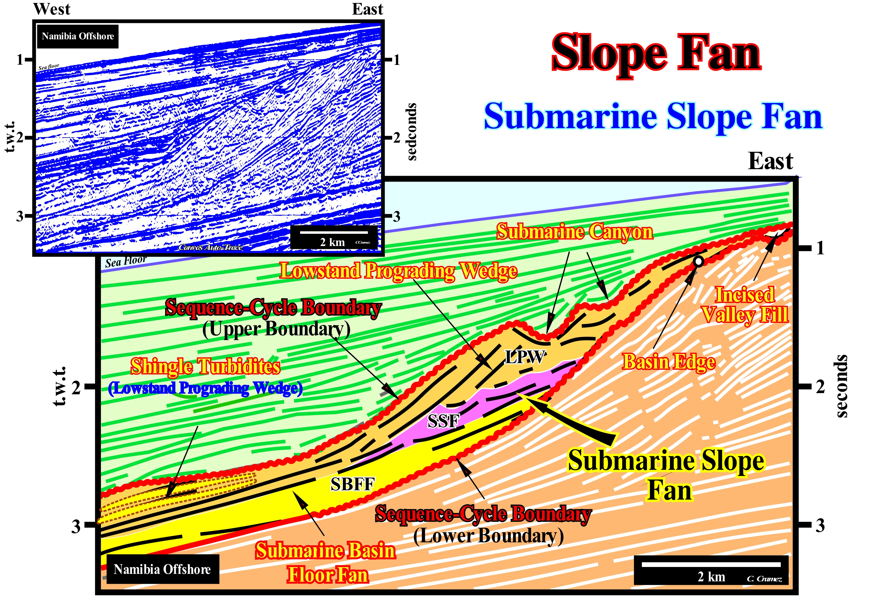
This figure illustrates a tentative geological interpretation of a Canvas auto-trace of a detail of a Namibia offshore seismic line, which corresponds to the stacking of three types of basins of the classification of sedimentary basins of Bally and Snelson (1980), which from the bottom to the top are: (i) A Paleozoic Folded Belt ; (ii) Late Jurassic/Early Cretaceous rift-type basins and (iii) A Mesozoic/Cenozoic Atlantic-type Divergent Margin. On this tentative interpretation, in the upper part of the divergent margin, an incomplete sequence-cycle, limited between two unconformities (wavy lines in red) is, perfectly, visible between the green (upper interval) and brownish intervals (lower interval). In this incomplete sequence-cycle, induced by a 3rd order eustatic cycle, whose time-duration varies between 0.5 and 3-5 My, the highstand systems tracts group (HSTG), that is, the set of the sedimentary systems tracts subgroups forming the transgressive interval (TI) and highstand prograding wedge (HPW) were not deposited. On the other hand, all the lowstand systems tracts subgroups are represented : (i) Submarine Basin Floor Fans (SBFF), coloured in yellow ; (ii) Submarine Slope Fans (SSF), coloured in violet and (iii) Lowstand Prograding Wedge (LPW), coloured in light brown, are present. The unconformities bounding this stratigraphic cycle, said sequence-cycle, are, easily, recognized by the geometric relationships between the reflectors, by the reflections termination (lapouts) and the submarine canyon and incised valley fills. The submarine canyon formed at the top of the continental slope when the relative sea level* fell, which induced the erosional surface (unconformity) that is the upper limit of the considered sequence-cycle. This canyon, which is twice cut by the seismic line, was filled, probably, by clayey sediments (taking into account the concave morphology of the upper boundary) deposited during the lowstand prograding wedge (LPW) of the overlying sequence-cycle. The incised valley was formed at the time of relative sea level fall responsible of the lower unconformity of the incomplete sequence-cycle. The incised valley that is located upstream of the basin edge was embedded in the highstand prograding wedge (HPW) sediments of the preceding sequence-sequence, probably, coastal plain sediments. The filling of the incised valley during the deposition of the terminal part of the lowstand prograding wedge (LPW) of the considered sequence-cycle, i.e, of the incomplete sequence-cycle. The middle subgroup of the lowstand systems tracts group (LSTG), that is, the submarine slope fans (SSF) are underlined, on this tentative interpretation by a violet colour. These submarine slope fans, which have a morphology similar to the P. Vail's "gull wings"mark, probably, a period of erosion and also a collapse of the basin edge (E. Mutti's model) can not be excluded. The combination of subsidence and absolute (eustatic) sea level (supposed global and referenced to the Earth's centre) may be created by a relative sea level fall, which exhumed the former continental shelf (the basin may not have a platform) turning it into a coastal plain as the sea level has become lower than the basin. Under these conditions, sedimentary particles are transported by turbidity currents to the deep parts of the basin forming submarine basin floor fans (SBFF), which are rapidly (geological time) fossilized by submarine slope fans (SSF), since the relative sea level stabilized or begun to rise. In this incomplete sequence-cycle, in the distal part of the lowstand prograding wedge progradations, sedimentary anomalies (shingled turbidites) are easily recognized. These turbidite deposits, whose progradational morphology is very sloping and in relay (shingled), are associated with landslides and failures of the continental edge, which in lowstand geological conditions coincides, roughly, with the shoreline and with the continental edge.
(*) Local sea level referenced either to the sea floor or the base of the sediments (top of the continental crust), which is the result of the combination of absolute (eustatic) sea level and tectonics (subsidence or uplift of the sea floor).
Slope Front Fill............................................................................................................................................Remplissage de front de talus
Preenchimento de frente de talude / Relleno de frente de talud / Slope Front füllen / 坡前填充 / Заполнение откоса уступа карьера / Riempimento del versante frontale /
Filling that expresses how a slope, in general, the continental slope is fossilized by the overlying sediments.
See: « Onlap »
&
« Stratal Patterns »
&
« Relative Sea Level Change »
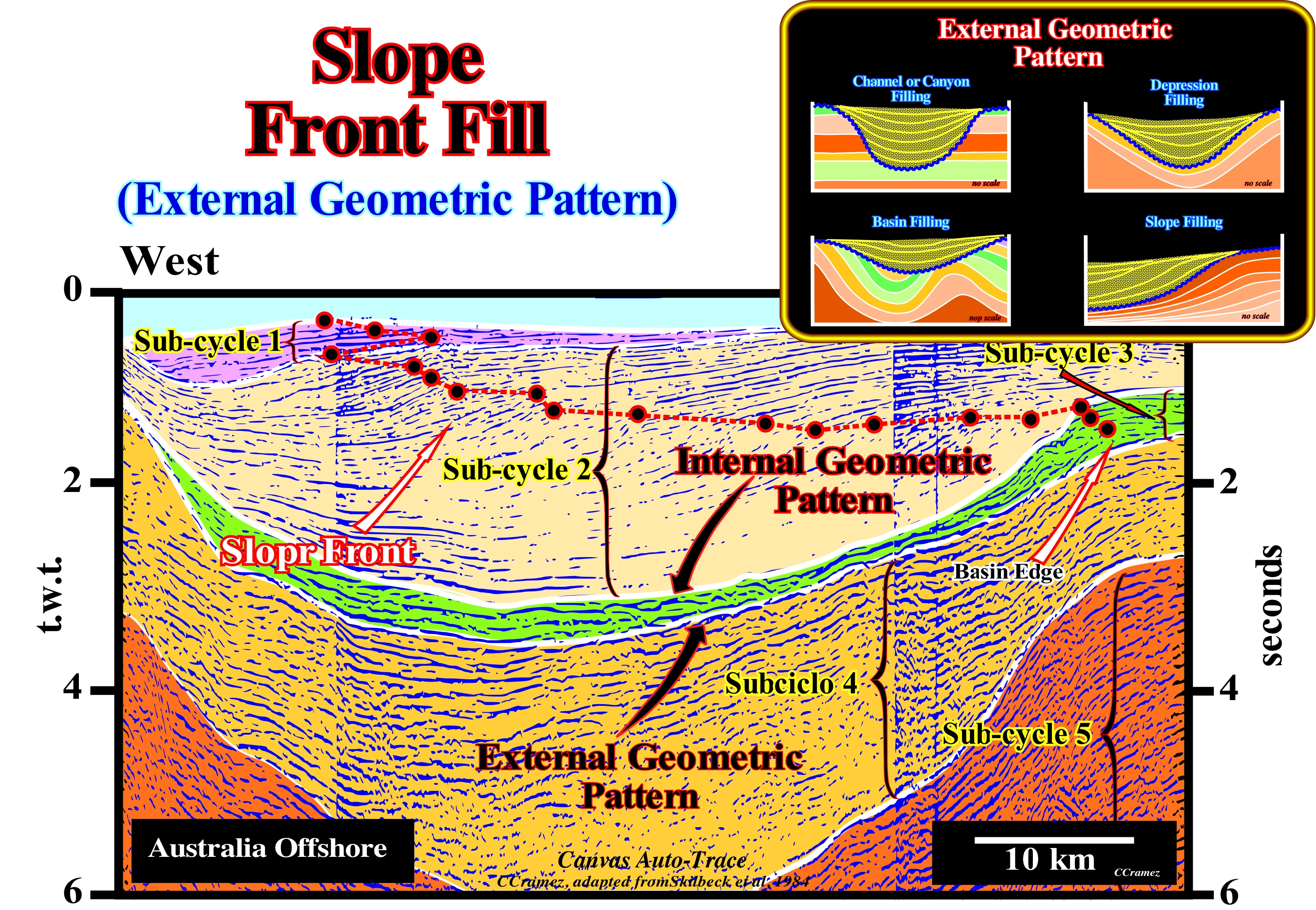
The western Australia offshore corresponds to the stacking of different basins of the classification of the sedimentary basins of Bally and Snelson (1980), which from bottom to top are: (i) A basement that corresponds, in most cases, to Paleozoic flattened folded belt ; (ii) Rift-Type basins that lengthening the Pangea supercontinent and especially its southern part, that is, the Gondwana small supercontinent, before the lithosphere breakup ; (iii) An Atlantic-type divergent continental margin, in which two sedimentary tectonic phases are distinguished: a) The transgressive phase with a retrogradational geometry, which is fossilized by the b) The regressive phase, whose geometry is progradational. These two sedimentary tectonic phases are separated by a downlap surface, in association with which marine rocks rich in organic matter were deposited, which are, probably, the main potential source-rocks of this offshore. This tentative geological interpretation of a Canvas auto-trace of West Australia offshore seismic line was made in continental encroachment subcycles induced by second-order eustatic cycles, whose time-duration varies from 3-5 My to 50 My and associated with changes in the tectonic subsidence rate (total subsidence, i.e., sediment thickness plus water-depth, decreased of the isostatic compensation effect, due to sedimentary overload, and increased by the compaction effect). The age differences between unconformities (erosional surfaces created by significant relative sea level falls) that separate the different encroachment subcycles must always be higher than 3-5 My and smaller than 50 My. On this tentative interpretation not only, the groups of sedimentary systems tracts can not be recognized, but it is very difficult to recognize in what periods the basin had or not a continental platform (shelf), which is, relatively, easy in a tentative interpretation made at the hierarchic level of a sequence-cycle. As illustrated on this tentative interpretation, the different unconformities were recognized, mainly, by the lapouts (reflection terminations) of the overlying reflectors (coastal and marine onlaps). In most cases, seismically, the reflection terminations of the reflectors underlying the dislocations are not very visible, but in some cases, toplaps (by truncation) are evident. In the last three continental encroachment subcycles (1, 2 and 3), the successive positions of the basin edge are easily recognized, as well as the filling of the continental slope front, particularly, in subcycle 2. The dip break of the lower unconformity of the subcycle 2 underlines the basin edge at the start of the subcycle. From this point, it is easy to see that the basin filling is progradational, i.e, the basin, downstream of the edge of the preceding subcycle, was filled by progradations that define the successive continental slopes. Taking into account the scales of the seismic line, and in particular the horizontal scale, it can be said that during subcycles 1, 2 and 3, seismically, the basin had no continental platform (no shelf). The successive basin edges, which here mark the continental edge, coincided with the outer limit of the coastal wedge or coastal prism of P. Vail. Under these conditions, it is very likely that in the distal part of most continental slope progradations shingled turbidites have been deposited (thickness less than the seismic resolution). This type of turbidite systems is more associated with instability of the basin edge than with significant relative sea level falls. Several relative sea level falls are visible within continental encroachment subcycle 2 (there are at least three coastal onlaps). However, they appear to have not been sufficiently important to change the geological conditions to lowstand geological conditional. Do not forget that at the level of a sequence-cycle, during the deposit of the lowstand systems tracts group, i.e., during the deposition of the subgroups: (i) Submarine basin floor fans (SBFF) ; (ii) Submarine slope fans (SSF) and (iii) Lowstand prograding wedge (LPW), the continental edge is not the basin edge. The basin edge is the last basin edge of the preceding sequence-cycle. However, during the deposition of the highstand systems tracts group (HSTG), i.e., during the deposition of the subgroups: (iv) Transgressive interval (TI) and (v) Highstand prograding wedge (HPW), the basin edge coincides with the continental edge, since the basin starts to has a continental shelf since the first transgressive surface.
Sloss' Sequence.................................................................................................................................................................................Séquence de Sloss
Sequência de Sloss / Secuencia de Sloss / Sequenz von Sloss / 斯洛斯序列 / Последовательность Слосса / Sequenza di Sloss /
One of the cratonic sequences proposed by Lawrence Sloss in 1963, which represents the time when the epeiric seas deposited sediments on the craton, whose upper and lower boundaries are delimited by regional unconformities formed during relative sea level falls.
See: « Sequence-Cycle »
&
« Systems Tract »
&
« Unconformity »
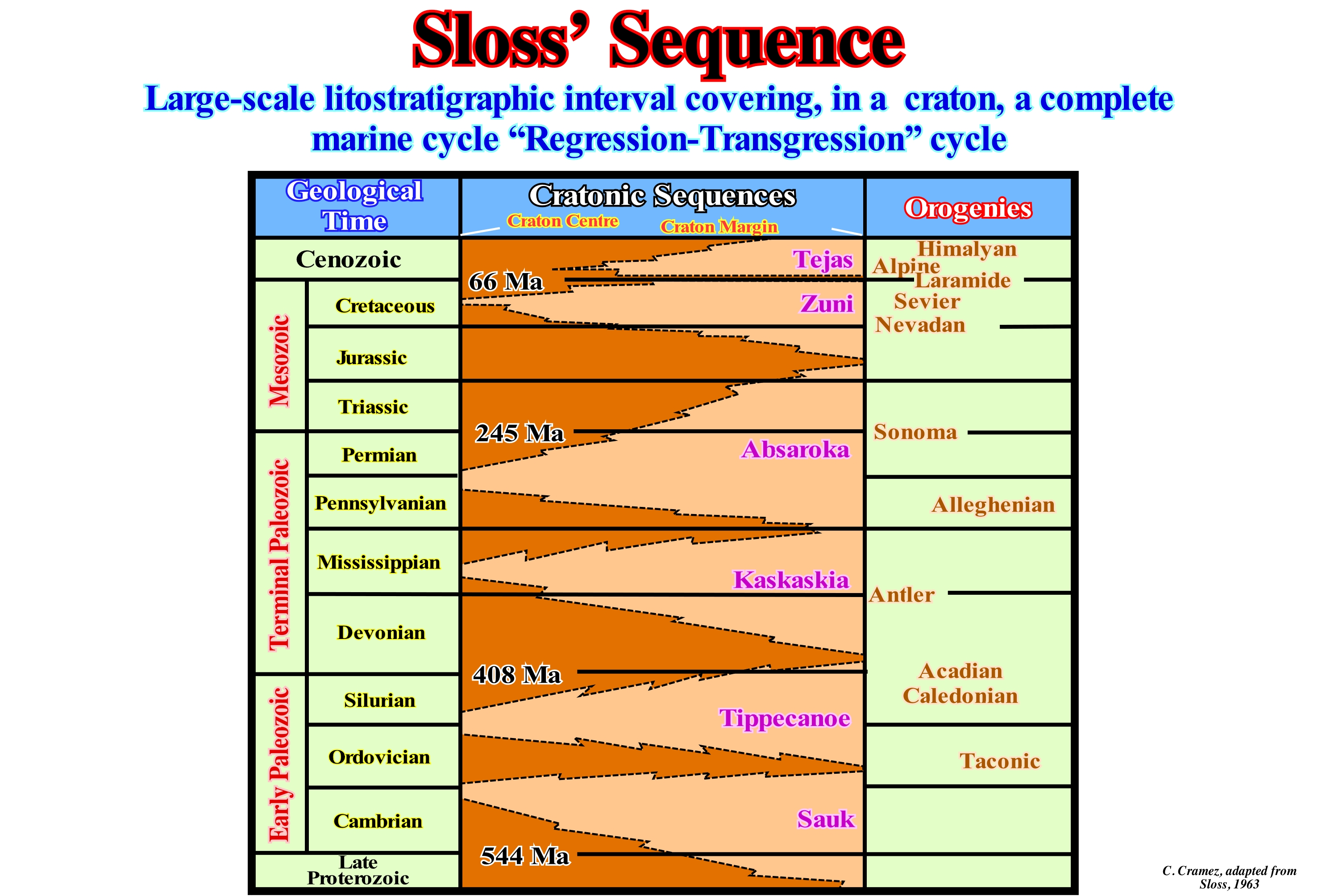
Laurence L. Sloss, in 1949, introduced the term sequence in the stratigraphy to designate a succession of strata bounded by unconformities (erosional surfaces). Later, in 1950, he considered a sequence as a set of depositional cycles (allostratigraphic units) and not as a chronostratigraphic unit, since the unconformities do not coincide with the timelines. In continuation of his works, in 1963, Sloss, already in the University of the Northwest, USA, proposed a new paradigm in the stratigraphy and particularly, In stratigraphic analysis. He recognized, at large scale, the importance of the sedimentary intervals limited by unconformities, which he called cratonic sequences (stratigraphic units of a hierarchy larger than a group, i.e., a megagroup or supergroup, which can be mapped over large areas of a continent and limited by interregional unconformities). This is why a geoscientist with experience in stratigraphy can look at an outcrop and say, for example, these Lower Cambrian sandstones were deposited in the Early Cambrian, or these clay limestones are, probably, of the Cretaceous, without the aid of fossils or a mass spectrograph (an instrument to study the different luminous spectra, especially, the arrangement of the stripes they present, with a photographic plate). Do not forget: Upper Cretaceous is for rocks and Late Cretaceous is for the time (ages). In the same way, a geoscientist in charge of tentative geological interpretation of the seismic lines, nowadays, perfectly, recognizes, for instance, the unconformity SB. 30 Ma, without it being necessary to drill a well in order to give an approximate age to the cuttings. Do not forget, too, that 30 Ma is by convention an age (millions of years ago) and 30 My is an interval of 30 million years, but it may be either Paleozoic and Cenozoic. It was Sloss who began the basic work of what is now called sequential stratigraphy, and it was he who said that each cratonic sequence is characterized by an internal tectonics and an idiosyncratic petrology (different from usual, different from that which is usually done). The depositional sequence of Vail et al., (1977), is a stratigraphic unit that is composed of a, more or less, concordant sequence of genetically related strata and limited at the top and bottom by unconformities or their correlative deep-water paraconformities. However, the depositional sequence of P. Vail has an order of magnitude (smaller hierarchy) than the Sloss' sequence. In the hierarchy "Sequence, Supersequence and Megasequence", initially, proposed by Vail, it is the supersequence that corresponds to the Sloss' sequence. In this figure are shown the North American craton sequences (Sloss' sequences), which are separated by unconformities (erosional surface induced by significant relative sea level falls). In the light brown coloured areas, the sediments have been eroded or not deposited, which means they represent a, more or less, important hiatus. In the cratonic basins and divergent continental margins, sedimentary records, which are, mainly, transgressive episodes (global continentward displacements of the shoreline and coastal deposits in association with an absolute (eustatic) sea level rise** and not relative) and regressive (seaward displacement of the shoreline and coastal deposits in association with an absolute (eustatic) sea level fall), are limited by unconformities. Some unconformities are minor, but others represent very long periods of time and can be recognized over great distances. The Sloss' sequences comprise sedimentary intervals that can encompass various geological systems (in North America, for instance, the beginning of the Ordovician corresponds to the culmination of the great transgressive Cambrian episode that Sloss called the "Sauk sequence."
(*) In this glossary, for various reasons, the term "sequence-cycle" is used as a synonym of depositional sequence (P. Vail ), as well as "continental encroachment subcycle" and "continental encroachment cycle" replace the term of "supersequence" and "megasequence" used, initially, by Exxon's Exploration Production Research (EPR) geoscientists.
(**) The absolute (eustatic) sea level is, global and referenced to the Earth's centre. It is the result of combination of: (i) Tectono-Eustasy ; (ii) Glacio-Eustasy ; (iii) Geoidal-Eustasy and (iv) Steric Sea Level Rise or thermal expansion of the oceans). The relative sea level, which can be referred to any fixed point on the Earth's surface, is the result of the combined action of absolute (eustatic) sea level and tectonic (subsidence or uplift of the sea floor).
Slump..................................................................................................................................................................................................................................................Glissement
Deslizamento / Deslizamiento / Abrutschungen, Erdrutsch / 滑坡 / Сдвиг, срыв (пород) / Franamento/
Rotating movement, downward and outward, towards the smallest confining pressure, of a set of rocks that move as a unit or as a set of units.
See: « Listric Fault »
&
« Sliding Mound »
&
« Proximal Turbidites »
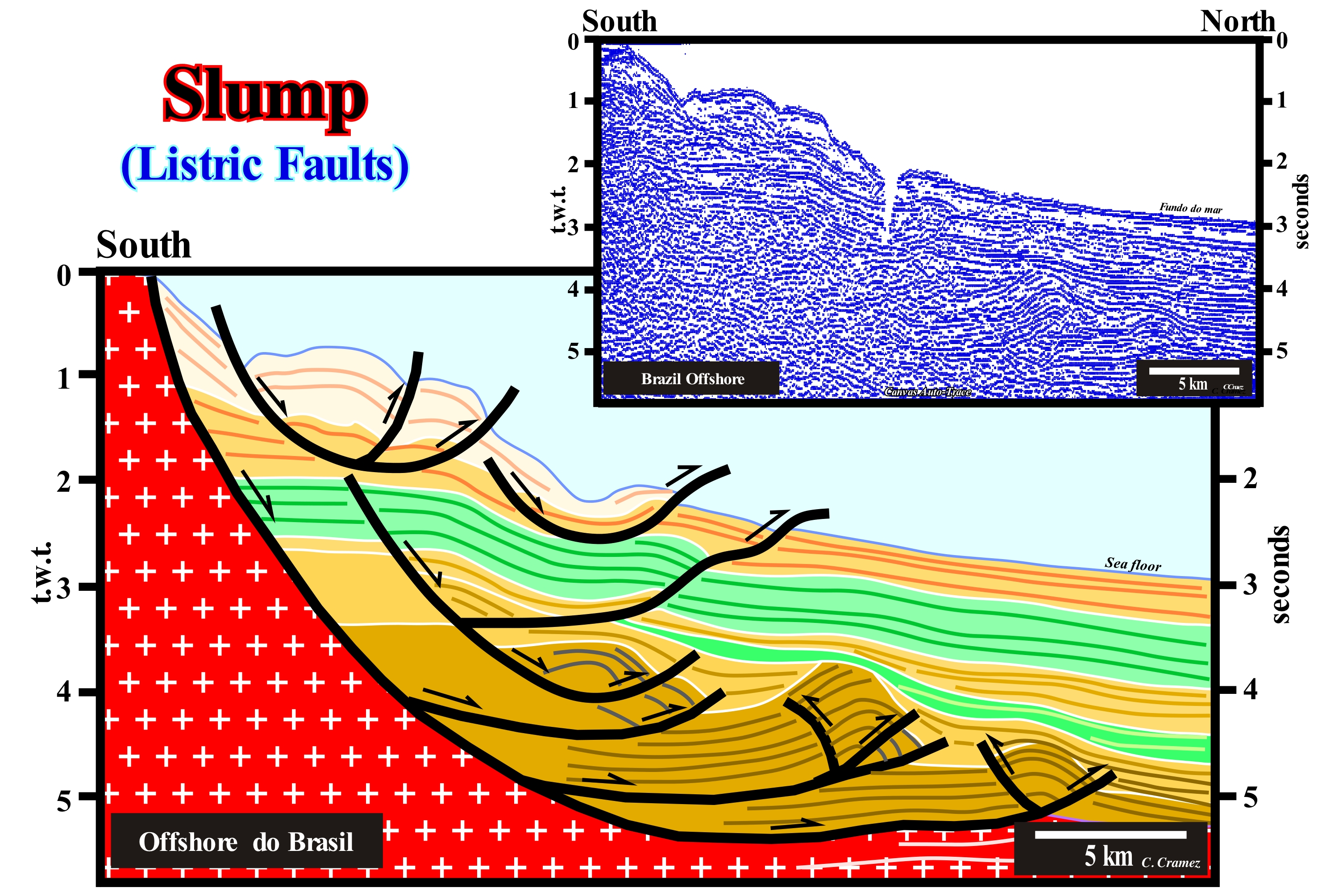
On this tentative geological interpretation of an offshore seismic line from the north Brazil (Barreirinhas offshore), the compressional structures, visible in the continental slope sediments of the lower seismic intervals, were created by a local compressive tectonic regime, defined by a particular ellipsoid of the effective stresses . This compressional regime, characterized by a horizontal σ1 (major axis of the ellipsoid), was induced as a counterpart to the gravitational landslides observed upstream and which are associated to an extensional tectonic regime defined by an oblong (σ1 vertical) ellipsoid of the effective stresses (sum of the geostatic pressure, hydrostatic pressure and the tectonic vector). The faults associated with these landslides are listric faults (from the Greek "listron" meaning "spoon"), i.e., upstream, the fault planes have a normal fault geometry (lengthening), while at the bottom, they have a reverse fault geometry (shortening). At the bottom of the fault plane, there is an excess of sediment and, to satisfy the new volume conditions (Goguel's Law), the sediments are forced to shorten (compression) forming anticline structures and/or reverse faults. In nature, there is just one way to lengthen the sediments (extensional tectonic regime). It is done by normal faults (with fault plane parallel to the ellipsoid's mean axis of effective forces, σ2). On the contrary, there are two ways in which sediments shorten, when subjected to a compressional tectonic regime. The first is the formation of anticline and syncline structures (cylindrical or conical). The second is the development of reverse faults. The folds (anticline/syncline) form first. The inverse faults are formed when the shortening produced by folding is insufficient. The formation of a compressional tectonic regime in response to an upstream extensional tectonic regime, as illustrated above, is formed just when the confining pressure is weak, which means that from a certain depth of burial (under a large sediment thickness), their formation is unlikely.
Smooth Long Term Eustatic Sea Level Curve....................................Courbe eustatique (Long terme émoussée)
Curva eustática ( de longa duração aplanada) / Curva eustática (aplanada de larga duración)/ Glatte langfristige eustatischen Meeresspiegel-Kurve / 光滑的长期海平面升降曲线 / Долгосрочная эвстатические кривая уровня моря / Liscio lungo termine eustatiche curva di livello del mare /
Curve derived from the smoothing of the long term curve, which, in turn, results from the flattening of the 2nd order eustatic cycles, whose time-duration varies between 3-5 and 50 million years.
See: « Eustasy »
&
« Eustatic Cycle »
&
« Stratigraphic Cycle »
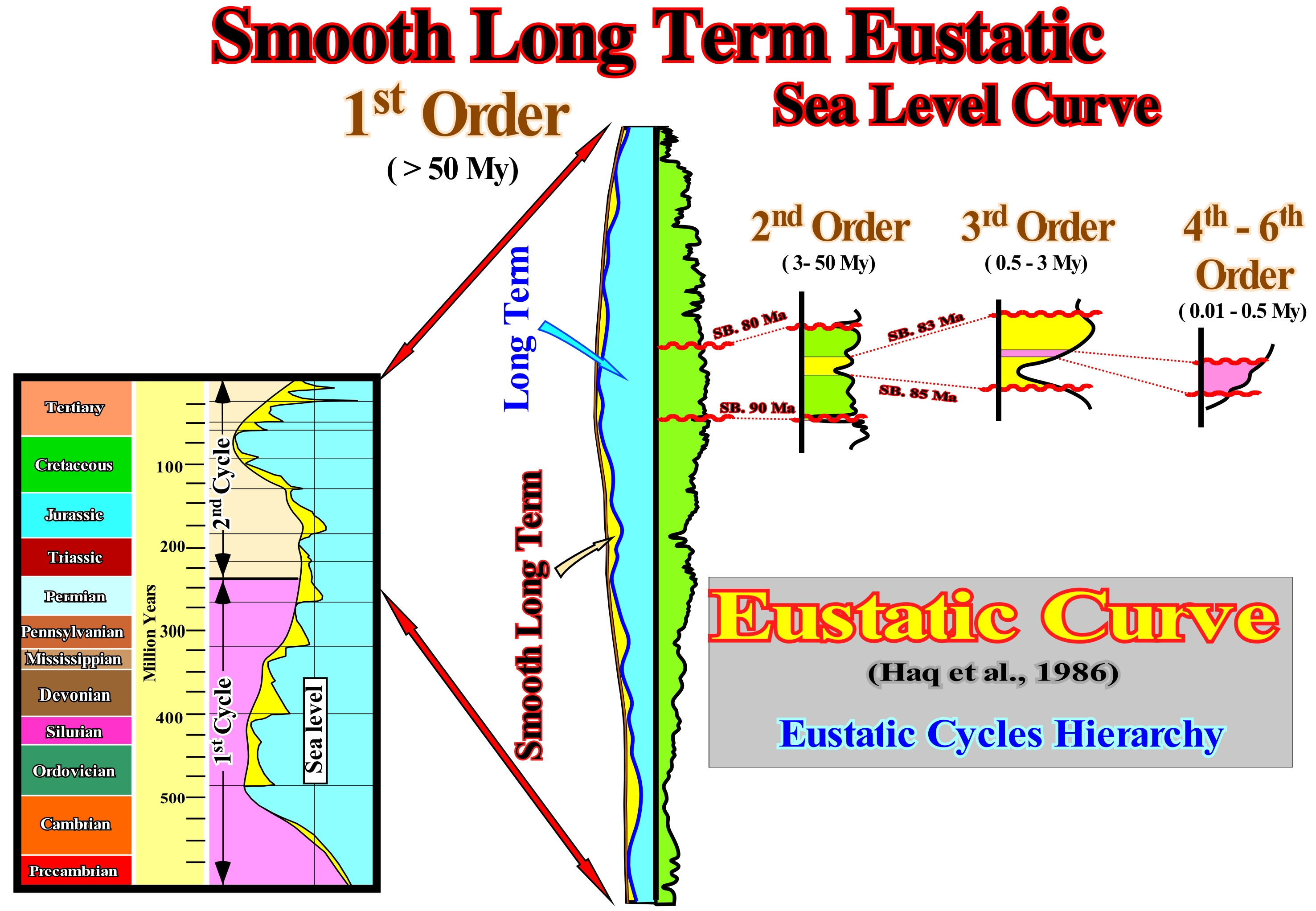
Considering that sea level can be: (i) Absolute or eustatic (supposed to be global and referenced to the Earth's centre and (ii) Relative (local sea level referenced to any point on the Earth's surface, which can be the base of the sediments or the sea floor) and assuming that since the Earth's formation (more or less 4.5 Ga), the total water volume is constant, a rapid oceanic expansion (sea floor spreading) induces a large volume of oceanic mountains and, therefore, the sea level rises encroaching the continents, allowing the deposition of sedimentary transgressions (set of increasingly important marine ingressions and increasingly smaller sedimentary regressions). On the contrary, a slow oceanic expansion induces a marine regression (sea level falling), i.e., that the shorelines are displaced seaward (seas withdraw from the continent and becomes restricted to the oceanic basins and areas of rapid tectonic subsidence). During the Phanerozoic, the amplitude of sea level changes appears to have been about 300 meters and the oceanic expansion rate about 2 to 6 centimeters per year (approximately the rate of growth of human nails). Sea level varies greatly in time and space. It is not fixed and it is not a horizontal surface. There are sea level variations, between different points, of several meters and global variations between different moments of the geological history. At present time, for instance, there is a sea level difference of about 40 m between Nova Scotia and Florida. Between the Maldives and Papua New Guinea the difference in sea level is over 200 meters. This means that a boat sailing between these two areas, along an equipotential surface of gravity, would not consume energy. On the other hand, sea level is affected by tides, wind, atmospheric pressure, local gravity differences, temperature, salinity, subsidence, etc. To determine the "mean sea level", the best thing to do is to determine a place and calculate the average level at that point and use it as a reference point. Generally, from hourly observations made over a period of 30 years* (for instance), the mean can be calculated for this measurement point. In sequential stratigraphy sea level changes must always be referenced to one point. Thus, geoscientists speak of relative sea level and absolute (eustatic) sea level. Obviously, relative sea level is the result of the combination of absolute (eustatic) sea level and the effects of tectonics (subsidence of the sea floor, when the predominant tectonic regime is in extensional or uplift, when the predominant tectonic regime is in compressional). The eustatic curve illustrated in this figure is the curve that Haq proposed for the Phanerozoic in 1986. This curve consists of eustatic cycles of several orders, which were defined on the basis of the duration time of each cycle. A 6th order eustatic cycle lasts between 0.01 and 0.03 My. A set of 6th order cycles form a 5th order cycle whose duration ranges from 0.03 to 0.08 M. A set of 5th order cycles forms a 4th order cycle whose duration varies between 0.08 and 0.5 My. A set of 4th order cycles forms a 3rd order eustatic cycle, whose duration varies from 0.5 to 3-5 My (in this example, the 3rd order eustatic cycle is limited between the unconformities, SB. 83 Ma and SB. 85 Ma. A series of 3rd order eustatic cycles form a second order eustatic cycle, whose time-duration varies between 3-5 and 50 My (SB. 80 Ma and SB. 90 Ma, in this A second order eustatic cycle forms a first-order eustatic cycle, whose time-duration varies between 50 and 400 My (SB. 0 and SB. ± 230 Ma, in this example). A certain order corresponds to the flattening of several lower-order eustatic cycles. The stratigraphic cycles deposited in association with first-order eustatic cycles are continental encroachment cycles (post-Rodhinia or post-Pangea for the Phanerozoic). association with eustatic cycles are continental encroachment sub-cycles. The stratigraphic cycles deposited in association with 3rd order eustatic cycles are the sequence-cycles. The stratigraphic cycles deposited in association with eustatic cycles of 4th, 5th and 6th are called high frequency cycles. In association with the eustatic paracycles which form the eustatic cycles, but between which there is no relative sea level fall, the sequence-paracycles that form, in particular the subgroups of sedimentary systems tracts forming a sequence-cycle are deposited.
(*) An average whether it is sea level or temperature, to have meaning it must cover a rather long period. The World Meteorological Organization (WMO) recommends that it must cover 30 years: from there one can speak of « normal ». A lot of geoscientists consider that speak in middle sea level or average Earth's temperature are pure abstractions since they do not correspond to any particular place.
Snell's Law........................................................................................................................................................................................................................................Loi de Snell
Lei de Snell / Ley de Snell / Snelliussches Brechungsgesetz / 斯涅尔定律 / Закон Снеллиуса (закон преломления света) / Legge di Snell /
When a wave crosses an interface between two isotropic media (same physical properties in all directions), the incident wave changes direction in such a way that the sine of the incident angle (angle between the incident wave and the perpendicular to the interface) divided by velocity of the first medium is equal to the sine of angle of refraction divided by the velocity of the second medium (law of refraction).
See: « Angle of Incidence »
&
« Geological Principle »
&
« Angle of Refraction »
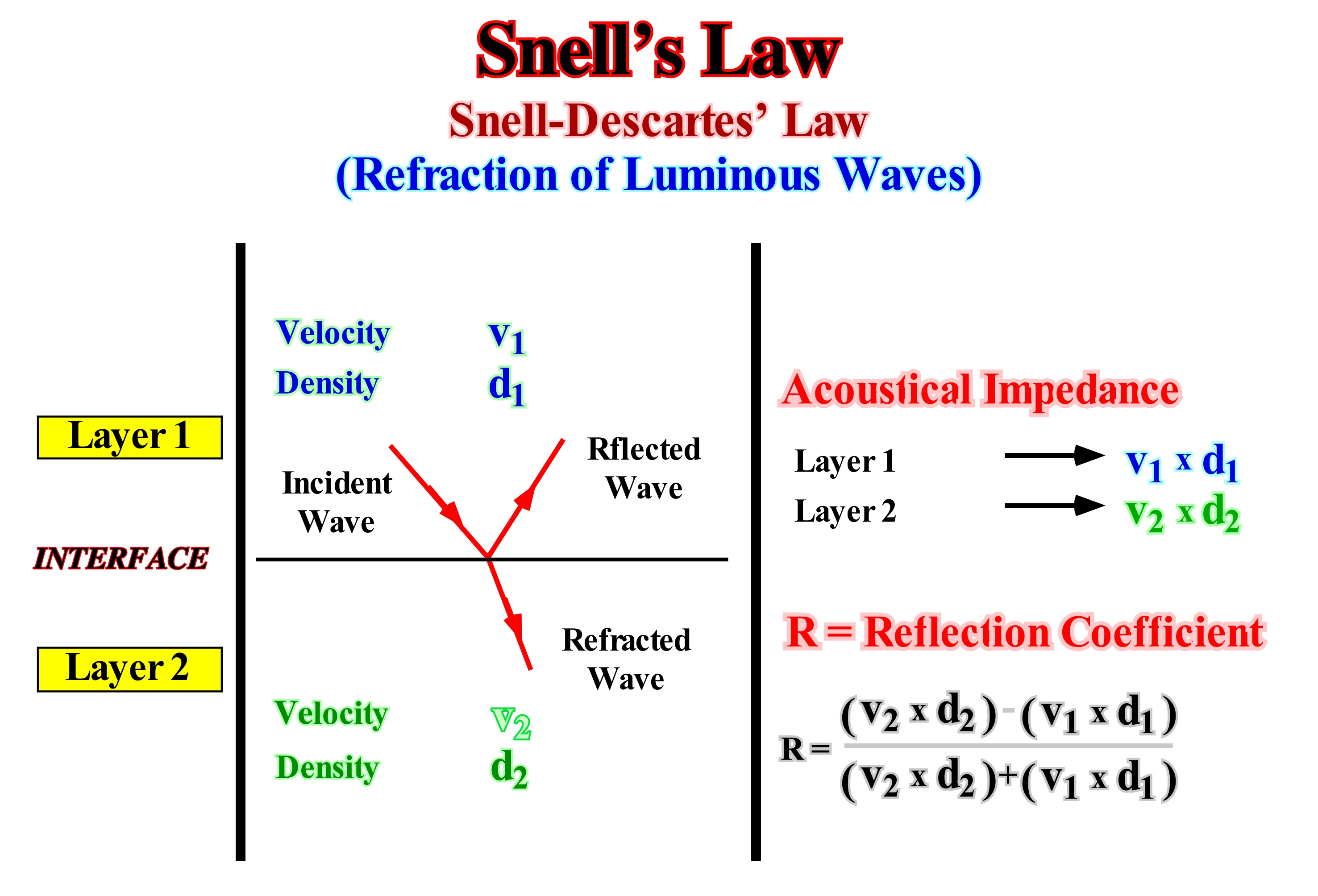
Refraction occurs at an interface between two materials due to the different acoustical velocities they have. The velocity of sound through each material is determined by the physical properties of the material, particularly, by the moduli of elasticity and density. When a wave encounters an interface between two materials with different acoustic velocities and the velocity of the lower material is higher, the portion of the wave in the lower material moves more rapidly, and it is because of this that the one where it deflects. Snell's law, also known as Descartes's law, since it describes the relation between the angles and velocities of the waves. Thus, if the horizontal acoustic velocity in the upper material is v1 and in the lower v2 and the angle of incidence is α1 and that of refraction α2, as illustrated above, Snell's law states that (sin α1/v1) = (sin α2 /v2). This means that Snell's law follows the principle of Fermat's minimum time. A wave always follows the fastest route, which is not necessarily the shortest. In the diagram shown in this figure there is also a longitudinal reflected wave, which is the wave which is reflected at the same angle as the incident, since the two travel on the same material, i.e. at the same speed. Assuming that the interface illustrated above corresponds to an interface between two sedimentary intervals with densities d1 and d2 and in which sound waves propagate with different velocities v1 and v2, which means that the intervals have different acoustic impedances (v1 x d1) and (v2 x d2), the reflection coefficient, which is the main responsible for the reflections observed in the seismic lines, is given by the relation between the difference and the sum of the impedances. As the incident waves oblique to an interface, are broken in reflected and refracted waves, this allows to analyse a succession of overlapping interfaces.
Snow Line......................................................................................................................................................................................................................Ligne de neige
Linha de neve / Línea de nieve / Schneefallgrenze / 雪线 / Снеговая линия / Linea di neve /
Lower limit of snow cover of last winter. To avoid confusion it is best to call it the snow line of a glacier. The term snow line is often also used to designate a small elevation in the lower edge of the snowfield. In mountainous regions, the snow line does not really correspond to a line, but to a more or less irregular border, whose position is determined by the amount of snow that fell in the previous winter, and by ablation, which are factors which can vary significantly from one point to another.
Ver: « Glacier »
&
« Accumulation Zone (glacier) »
&
« Firn »
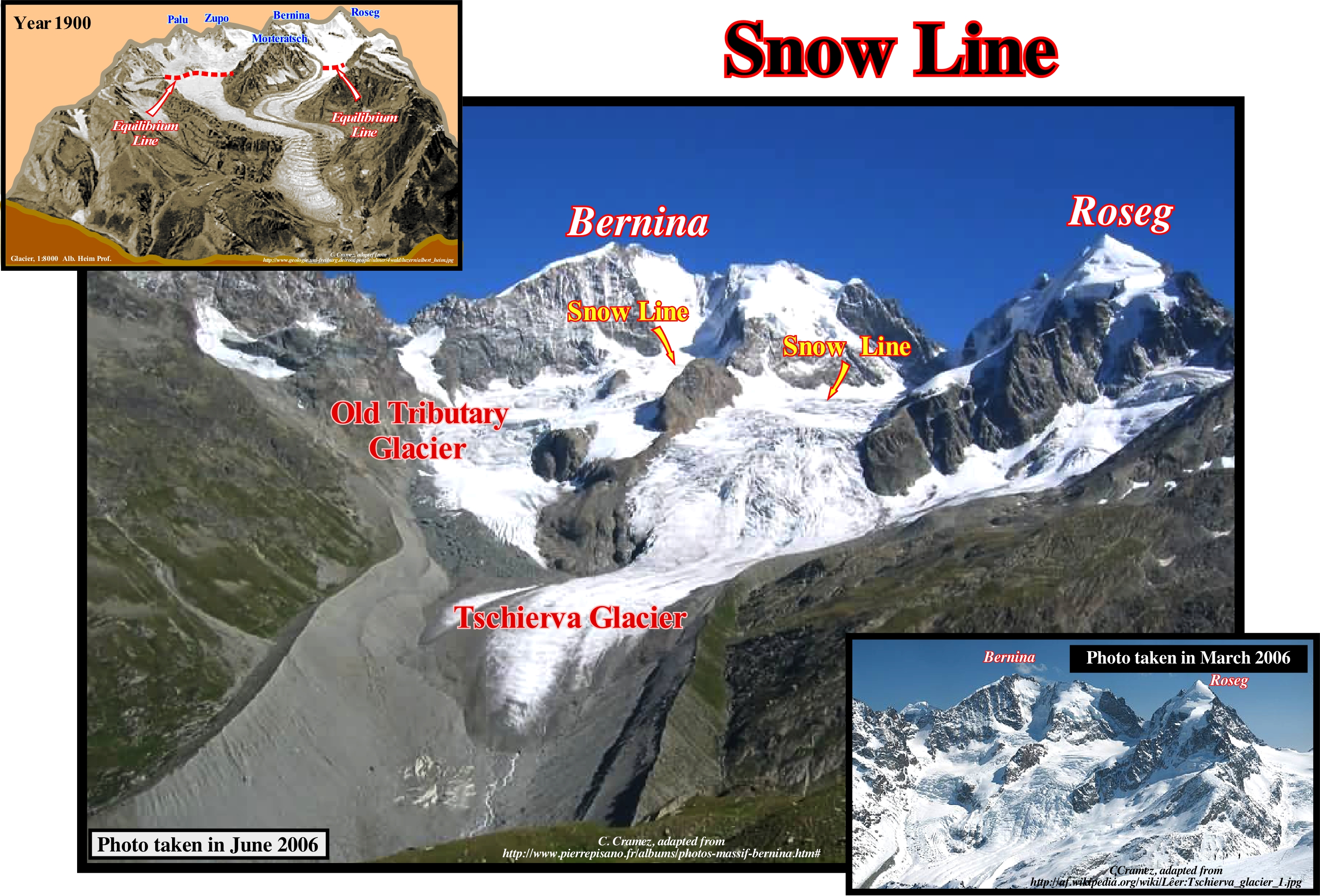
In this photograph, taken more or less from Corvatsh peak, one can see the Tschierva glacier, located in the canton of Grisons (eastern Switzerland), between the Roseg peak on the right (3,937 meters high) and the Bernina peak (4,040 meters) on the left, decorated with a large ridge of ice ("Biancograt"). The Tschierva refuge is visible above the left side of the glacier. In 2005, the glacier was about 4 km long, and its surface was about 6 km2 (determined in 1973). However, it is difficult to know whether these measures are taken in summer or winter. In fact, although these two photographs were taken in the same year (2006), they suggest very different dimensions and things. One was taken in summer (June) and one in winter (March). The first, taken in the summer, is used by the "Warmist"* and "Alarmists" (those who religiously believe in anthropogenic "global warming") and the second by the "Sceptics**" (those who do not religiously believe in "global warming" whether anthropogenic or not, but in natural climate change). On this subject it is important do not forget that there is several climate - citizens: (i) Scientists ; (ii) Warmists ; (iii) Climate-realistics ; (iv) Climate-pessimistics ; (v) Climate-skeptics and (v) Journalists (Giles Brien, 2017-ISBN 978-2-2619-4975-0). On the other hand, it is interesting to compare these days with the block diagram of the same area constructed by prof. Albert Heim in 1900, which suggests that the retrogradation of the Tschierva Glacier in about 100 years is a few hundred meters. In any case, and in particular in the photograph taken in the summer (the major), all the main elements are recognized, which can be evidenced in a glacier: (i) Mountain peaks (Bernina and Roseg) ; (ii) The glacial cirque ; (iii) An old tributary glacier (which is no longer, but will be, during the new global cooling period, which seems to have already begun, solar cycle 24) ; (iv) Two snow lines, which are very well recognized in both glaciers by the colour difference; (v) Two suspended glacial valleys (U-shaped) ; (vi) The main glacier valley ; (vii) Slots or fissures of glaciers ; (viii) The moraines ; (viii) Slope debris and the upper part of the outwash plain.
(*) The "warmist" is a name given to one who believes that globlal warming is real. On this subject, it is interesting do not forget that warming has been caused by man. This term also includes "alarmists", disaster-stricken and end-of-the-world people at the climatic sauce. They want to stop the progress and bring us back to the age of the caves, say of them the climato-skeptics. For the most extreme "warmists", humanity is a harmful species that dares to abuse the planet. In general, the "warmists" and their supporters are younger than the other groups. The brilliance shots are their specialty. (Giles Brien, 2017-ISBN 978-2-2619-4975-0).
(**) For skeptics, climate change is not real, or they think t Man has nothing to do with it. The case is nothing more than a conspiracy by the media, or a way for scholars to get subsidies. (Giles Brien, 2017-ISBN 978-2-2619-4975-0).
Soft Mud (Ooze)........................................................................................................................................................................................................................Vase (Boue)
Vasa (barro, lama) / Barro, Lodo / Schlamm / 渗 / Ил (липкая грязь) / Melma /
Very fine sediment, formed by pelitic particles of clay minerals, iron, manganese, carbonate and organic matter, which forms, usually, in estuaries, deltas, marine marshes and large oceanic bottoms.
See: « Sediment »
&
« Organic Matter (types) »
&
« Pelagic (deposit) »

Note that (i) Bio-ooze; (ii) Biogenic ooze; (iii) Biogenic mud ; (iv) Biogenic sludge; (v) Pelagic ooze, etc., are, practically, synonymous of ooze. They designate a type of pelagic sediment, or substance, which either deposits in the bottom of the oceans, lakes or rivers and which contains more than 30% of biogenic material. This means that depending on the sedimentary environment, the pelagic sedimentation velocity is very different. In fact, it varies between 1 mm and 10 cm per 1,000 years in marine and lake environments, but is much faster in fluvial environments. In a river system there may be, depending on the overbanking and subsequent return of the river to its bed or due to the avulsion of a river channel, formation of mud along the floodplain, since they are formed by the organic material that was submerged by the water of the river on the plain or by the lake formed in the abandonment of the canal. The organic material that forms these deposits can be of animal origin (mainly fish) that form the organic slime in the sea floor and or of vegetable origin. The sedimentation rate of this type of ooze, which can give rise to peat, is much higher than the typically pelagic muds. Among the ooze formed from limestone particles, the most known and abundant are: (a) Ooze with foraminifera that are milky in colour and very frequent, especially in the Atlantic Ocean ; (b) Ooze with calcareous nanofossils composed essentially of coccoliths, smaller than foraminifera ; (c) Ooze with planktonic gastropods with aragonite shells; (d) Siliceous ooze constituted, mainly, by diatom and radiolaria frustules. The ooze with diatoms predominate in the cold seas, while the ooze rich in radiolaria are formed in the equatorial waist and particularly in the Pacific Ocean. At great depths, the ooze are brownish red and made up of clay minerals, cosmic granules, volcanic dust, and microscopic nodules.
Soil.......................................................................................................................................................................................................................................................................................Sol
Solo / Suelo / Boden / 地面 / Земля (почва) / Suolo /
Set of the geological horizons suprajacentes to the rocky substratum that have of variable thickness and that are formed by mineral constituents, that differ from the original materials by their morphological, physical and mineralogical characteristics.
See: « Fragipan »
&
« Erosion »
&
« Weathering »
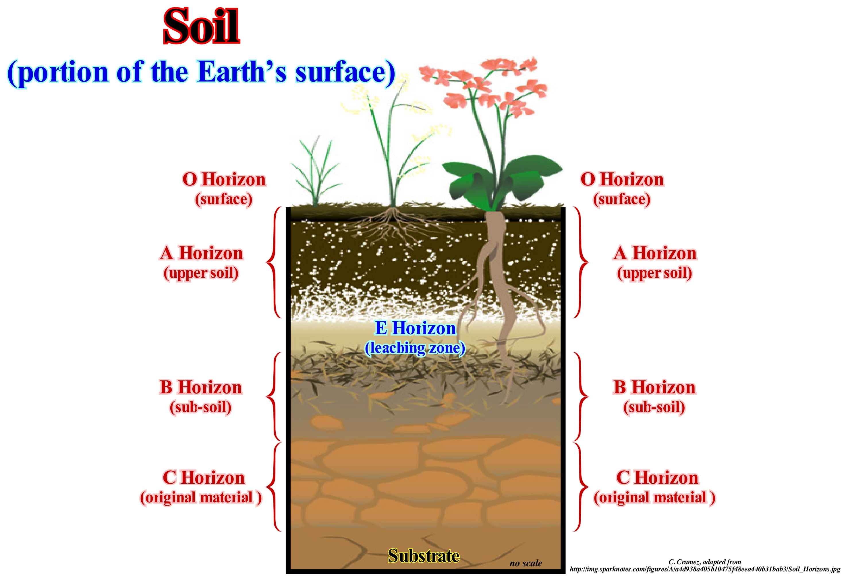
Soil is a set of unconsolidated material that covers the emerged terrestrial surface between the lithosphere and the atmosphere. Soils consist of three phases: (i) Solid (minerals and organic matter); (ii) Liquid (soil solution) and (iii) Gaseous (air). These phases can be found in different proportions, depending on factors such as soil type and use. Soil and the product of weathering (a set of physical and chemical phenomena that lead to the degradation and weakening of rocks) on a source material, the transformation of which develops in a given relief, climate, biome and over time. A soil, however, can be viewed in different ways. For an agronomist, a soil is the layer in which plant life can develop. For a civil engineer (soil mechanics point of view), a soil is a excavable body that is used as a support for construction or building material. To classify a soil, one must take into account its diagnostic horizon within the soil (horizons O, A and B together). This is a soil horizon, with characteristics predetermined by the taxonomy to be used by the pedologist (geoscientist who studies the physical, chemical and biological characteristics of soils). The formation of a soil depends a lot on the climate. Soils from different climatic zones have different characteristics. Temperature and humidity affect weathering and leaching. Wind moves sand and other particles, especially in arid regions where there is little vegetation cover. The type and amount of precipitation influences soil formation, affecting the movement of ions and particles through the soil, thus aiding the development of different profiles. Daily and seasonal temperature fluctuations affect the effectiveness of water in weathering the parent rock material as well as the dynamics of the soil. Temperature and precipitation rate affect biological activity, the speed of chemical reactions and types of mulch.
Sole Mark..........................................................................................................................................................................................................Marque d'érosion basale
Marca de sedimentação / Marca de sedimentación / Marke Erosion basalen / 品牌侵蚀基底 / След базальной эрозии / Marca d’erosione basale /
Figure in a bedding plane, which corresponds, generally, to a depression mold on the lower surface of the overlying layer. The sedimentation marks, usually, result from the filling of the impressions made on the surface of a muddy sediment either by the erosive action of a stream or by the impacts of the objects carried by the stream. The deposited sediments, subsequently, fill the depressions and thus they are preserved, in relief, at the base of the overlying bed.
See: « Stratum »
&
« Saltation (transport) »
&
« Ravinment »
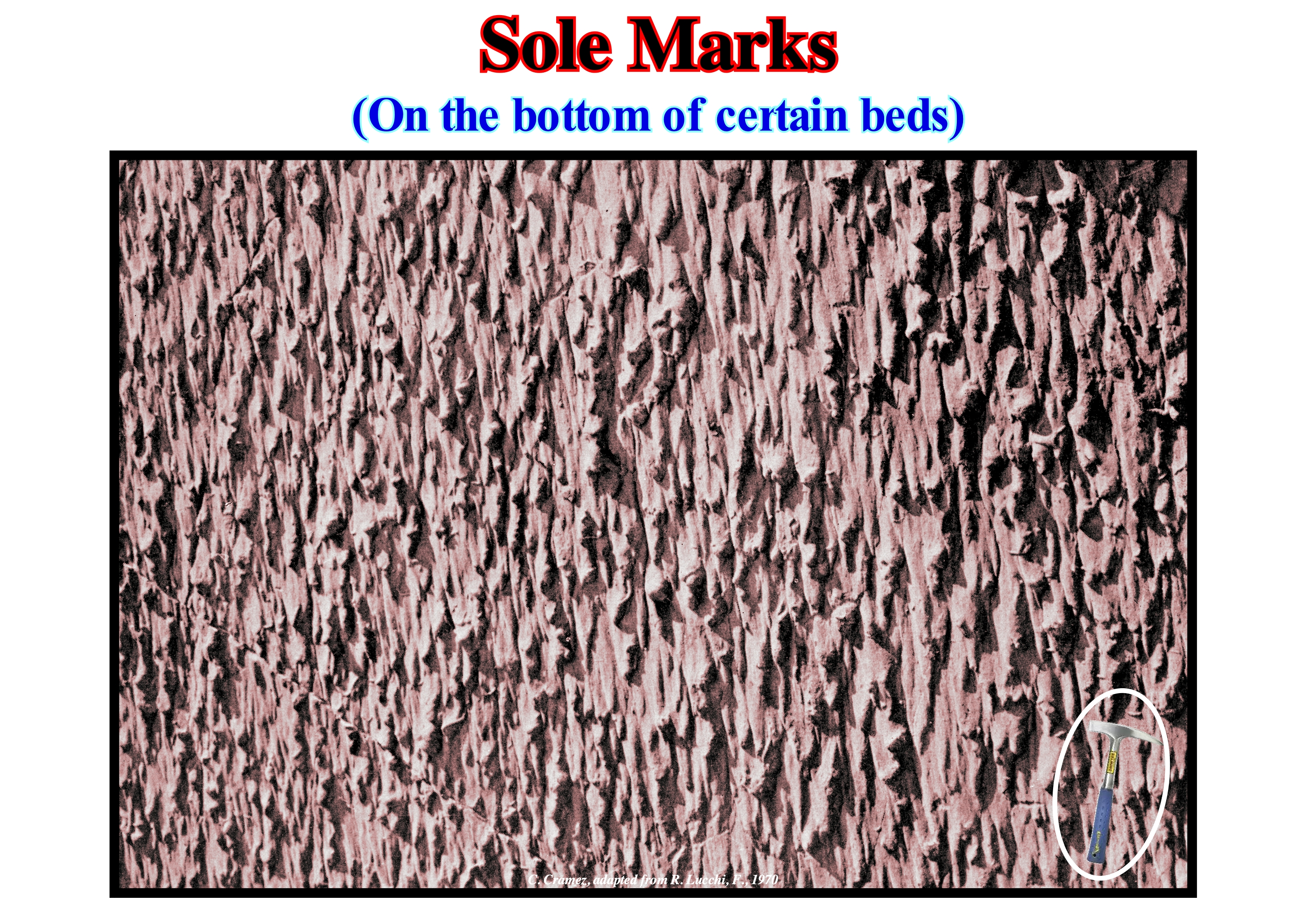
This photograph shows visible sediment marks on a large block, which is not in its original position. This type of sedimentation marks (in relief) can not be found on the upper surface of sand or clay layers, but on the lower surface. These sedimentation marks, which are often found on the lower surface of finning upward sand layers (mainly in submarine basin floor fans), underline the erosion that the bedding plane of the pelagic layer underwent when turbidite current (tractive and turbulent) responsible for deposition of the sand layer. Thus, not only can these marks be used to indicate the original position of a bed, which is very useful in areas where the sediments have been greatly shortened by one or more compressional tectonic regimes, but also to indicate the more likely direction of the paleocurrentes. In a turbidite depositional system there is a large hiatus between the turbidite layer itself, which in geological terms is, instantaneously, deposited (minutes, rarely hours) and the overlying pelagic layer, whose the deposition time can be several tens or thousands of years. The first is associated with a turbidite current, probably, formed in association with a significant relative sea level fall, which put the sea level lower than the continental edge (which may or may not coincide with the basin edge) creating lowstand geological geological conditions (Vail's model). For E. Mutti, certain turbidite currents can form in highstand geological conditions, in association with continental edge instabilities or river floodings. The pelagic layer between the turbidite layers results from a slow deposition (far from the coast) of marine sedimentary particles not transported by the turbidite currents.
Solifluction............................................................................................................................................................................................................................Solifluxion
Solifluxão / Solifluxión / Solifluktion / Solifluction (群眾運動) / Солифлюкция (течение грунта) / Soliflussione /
Flowing coast below a saturated water soil. As the permafrost is impervious to water, the overlying soil can become saturated and thus slide down the coast due to the force of gravity. The downward movement, which can deform or completely destroy soil stratification plans, generally, has a maximum rate of a few centimeters per day.
See: « Permafrost »
&
« Porosity »
&
« Debris Flow »
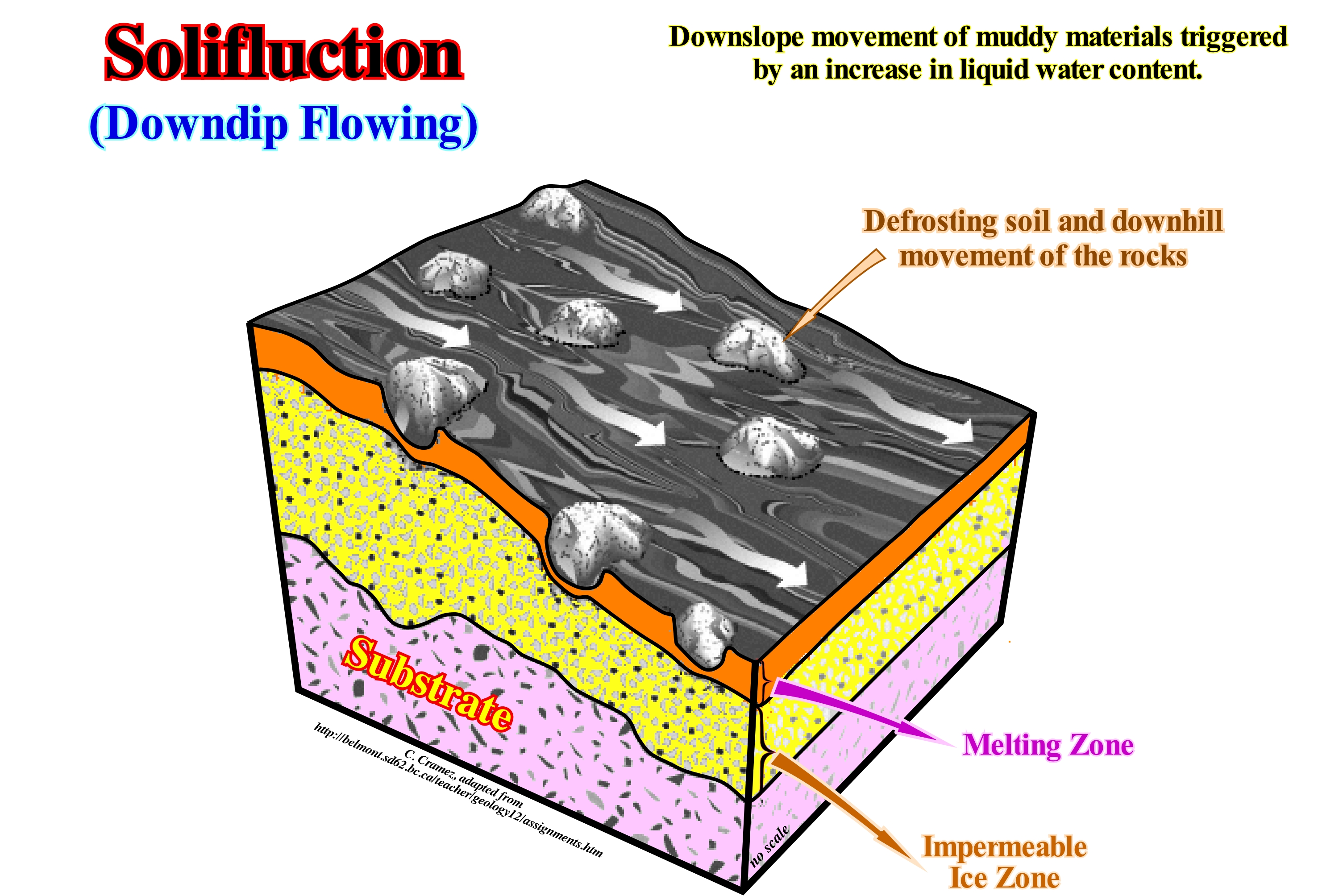
In geology, solifluction, also known as soil flux, is a type of mass loss where the saturated sediments move slowly, downhill, over an impermeable material. A slow drag movement of soil under the action of gravity is, often, triggered by rainwater infiltrated, interstitially, in clay sedimentary particles, which decreasing the cohesion of these particles makes the soil mass more plastic and dense. Solifluction occurs in periglacial environments, where melting of ice during the hot season produces a water saturation on the surface of the thawed material (active layer), causing a form of "flow" downstream. This flow is due to the lifting produced by frost, which occurs, usually, on a slope as well as, on a small scale slip. Solifluction may occur on hillsides or gentle slopes (less than 0.5° dip), at a velocity between 0.5 and 15 cm/year. The velocity of displacement of the terrains by solifluction is very small. It can be just few centimeters or few meters per year. In periglacial environments, solifluction phenomena are very important, particularly, in the interstitial ice melting season. When the water that saturates the materials comes from the melting of the ice, the phenomenon is called gelifluction. The movement of the displaced material is carried out on impermeable material, which may consist of non-weathered rocks or iced soil. The slopes affected by solifluction phenomena present specific morphological characteristics, which are manifested by bulges of their surface corresponding to displaced masses of land. Depending on their shape and size, they are referred to as drains, lobes, benches and solifluction mantles. The creep* (deformation over time of a material subjected to a load or constant stress) is a similar process, but is not dependent on freeze cycles.
(*) Slow downslope movement of sedimentary particles that occurs on every slope covered with loose, weathered material.
Solution Bench (Dissolution platform)........................................................................................................................................................Vasque
Vasque / Vasques, Cubetas / Pfame, Becken, Quelltöpfe / 解决方案长椅 / Бассейны / Soluzione panchine /
Small dissolution platform with flat bottom or with very small littoral clints, with fissures, surrounded by a low edge of 10 to 30 cm. Solution benches may appear staggered or not. The origin of the solution benches is attributed to the enlargement of the littoral waterpockets and to the mechanical and chemical erosion of the coastal lapies (littoral clints), beeing the edge a vestige of the initial surface (erosional edge). Sometimes, the edge is totally or partially bioconstructed by mollusks and algae.
See: « Karst »
&
« Karstification »
&
« Erosion »
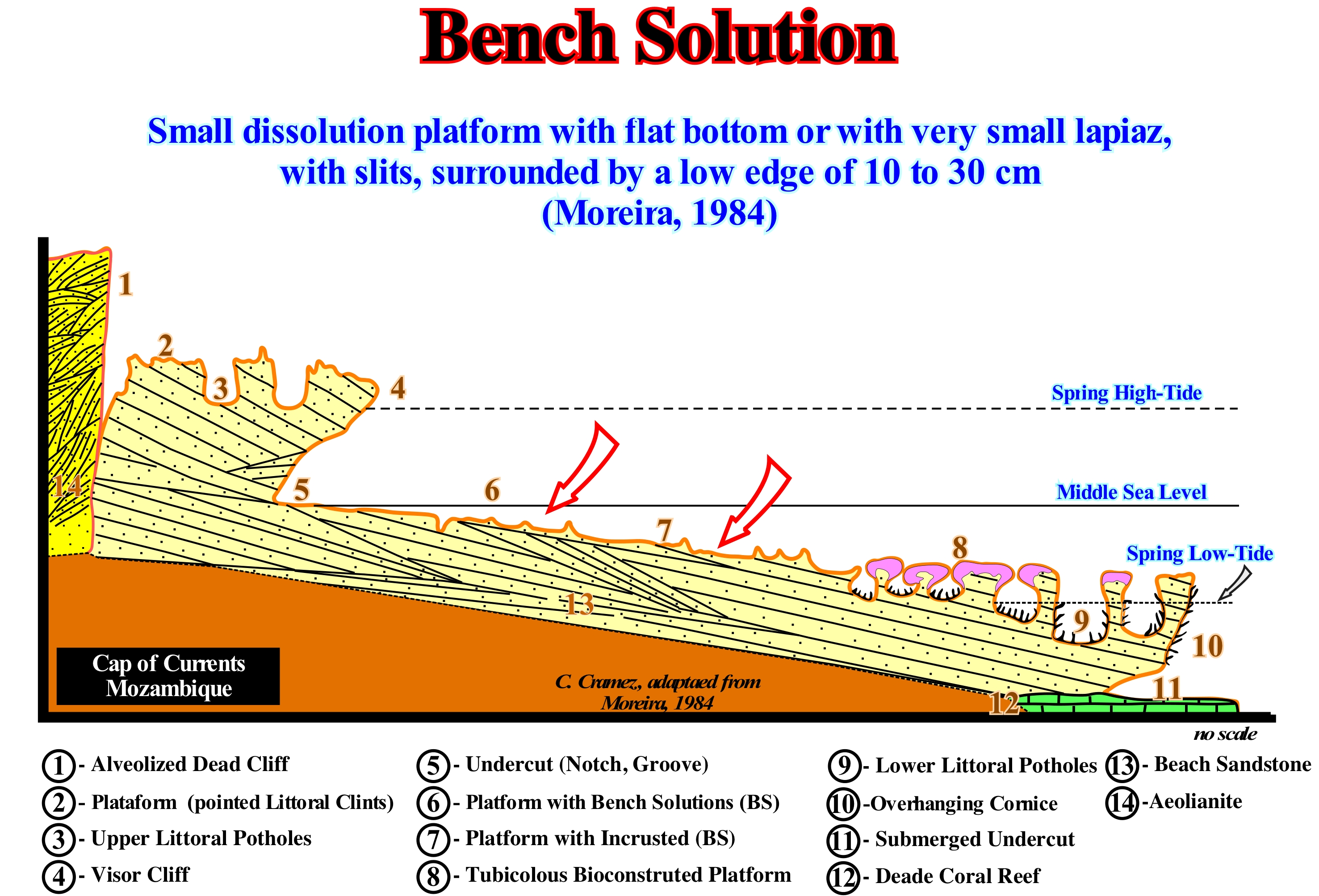
This geological section of the Jangamo Point (Cabo das Correntes in Mozambique) illustrates the zonation and the main types of microforms of the coastal karst, in aeolianites, i.e., in rocks formed of sand, sometimes limestone, stacked by the wind (dunes) and beach sandstones: (1) Abandoned cliff with corrosion honey-combs ; (2) Platform with littoral clints ; (3) Coastal potholes or water-pockets ; (4) Visor of active cliff ; (5) Undercut, groove or notch ; (6) Platform with solution benches and embryonic water-pockets ; (7) Platform with solution encrusted with calcareous algae ; (8) Tubicolous Bioconstructed Platform ; (9) Coastal potholes (water-pockets) ; (10) Overhanging surface cornice ; (11) Submerged undercut (notch, groove) ; (12) Dead coral bank ; (13) Beach sandstone and (14) Aeolianites. Bench solutions or dissolution platforms, are also very common in areas where the coastline is composed of reefs and calcareous sands as, for instance, in the Hawaiian Islands. A detailed description of the characteristics and formation of bench solutions on this islands was given by Wentworth (1939), where the shore profile is very similar to that illustrated in this figure: (i) In general, they are several hundred meters long (parallel to the shoreline) and a width between 1,5 and 20 meters ; (ii) They are very smooth ; (iii) Its surface, normally, has variations in altitude not exceeding 7-15 cm in an area of 15 by 30 meters ; (iv) The outer edge rises, more or less, abruptly from the water ; (v) The surface is, generally, a few centimeters or one meter above sea level and there is no sea side parapet ; (vi) Bench solutions, properly speaking, are formed by reef limestones, which contribute to the construction of bench solution seaward ; (vii) These bench solutions, mainly inland, near the coast, are formed by the dissolution of the limestone of the coastal stones by rainwater.
Sonic Log...................................................................................................................................................................Diagraphie de la vitesse (Sonique)
Diagrafia de veocidade (sónico) / Perfil de velocidad (sónico) / Sonic-Protokoll / 声波测井 / Диаграмма акустического каротажа по скорости / Registro sonico /
Electric log that measures the length of time that the sound waves emitted by the upper part of the electric probe spend to transit to the bottom via the walls of the well, i.e., via the adjacent geological formations.
See: « Electric Log »
&
« Acoustical Impedance »
&
« Formation (geological) »
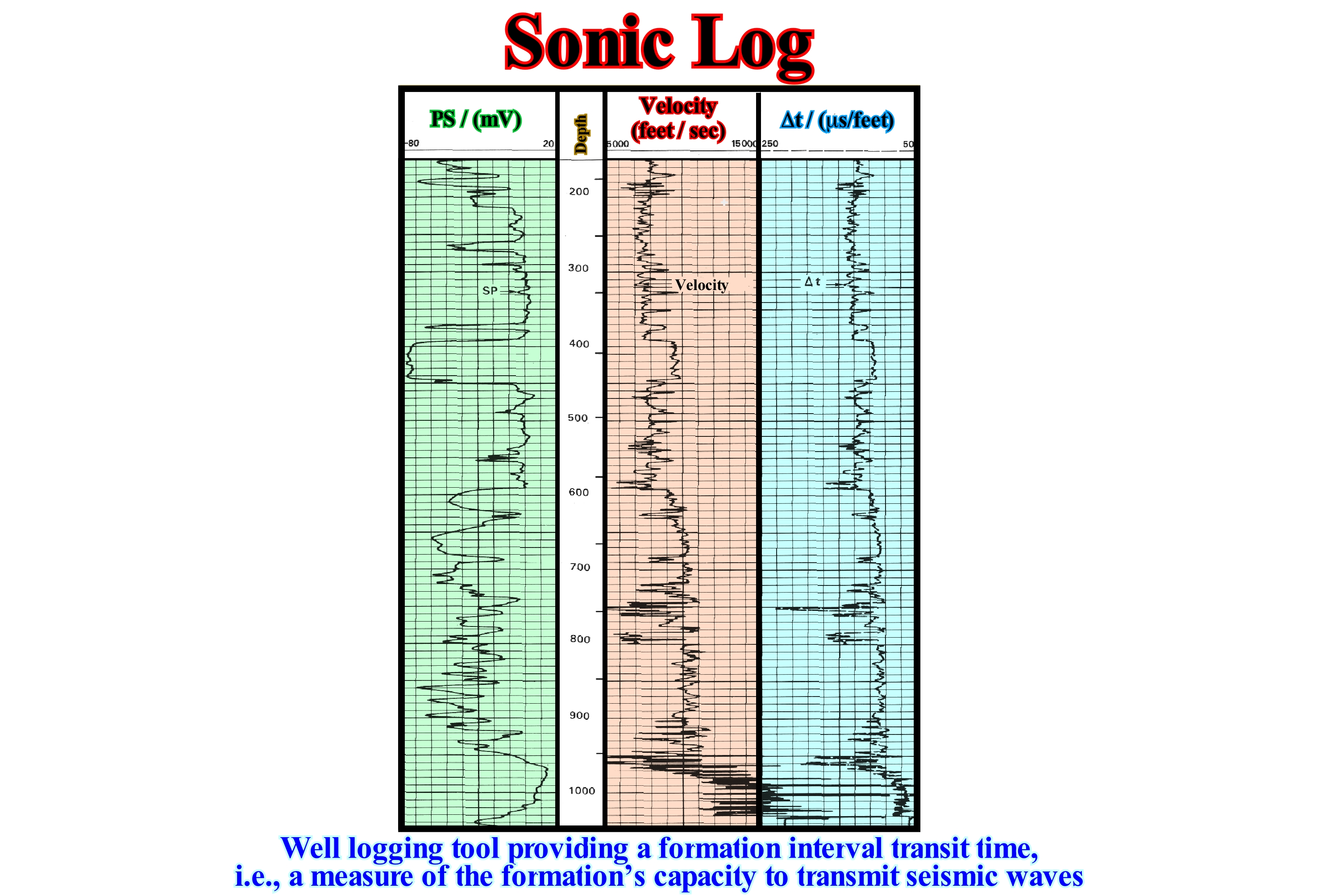
In the velocity log (sonic), the transit times of clicks emitted from one end of the probe are recorded by one or more receivers placed at the other end. Sound waves usually travel faster in geological formations than in drilling mud. The transit time interval (Δt), which is measured in microseconds per feet can be used to calculate the porosity according to the following formula: Φ = (Δt log - Δt ma) / (Δt f - Δt ma), where Δt log is the recorded transit time interval, Δt ma is the rock velocity at Φ = 0 and Δt at the velocity of the pore fluid. Sonic logs can be applied to cased or uncased wells. The sonic log is, from the diagrams that allow to calculate the porosity, the less rigorous. It is very influenced by the lithology. Since acoustic waves travel faster in limestones than in sand and clay (taking into account compaction), it is, mainly, used to identify lithology and thus to correlate different wells. It is very useful to geophysicists since it allows determining the interval velocities of the geological formations and thus correlating the time of the seismic reflectors to the rocks around the wells. In this figure, there is also shown the spontaneous potential (SP) log, which records the electrical potential between an electrode placed on the probe and an electrode fixed to the surface. This log may also be used either in cased or uncased wells. As long as a geological formation has a minimum of permeability, the the spontaneous potential logs respond to the difference in salinity between the drilling mud and the formation water. The electric charge is produced by the flow of ions (Na+ and Cl-) from the more or less concentrated solutions. Typically, the flow is salt water for the drilling mud, which is, generally, not salty. The electrical potential is, basically, related to the formation permeability.
Sorting (Calibration)..............................................................................................................................................................................................................................Trie
Calibração (Triagem) / Calibración / Sortierung / 排序 / Сортировка / Calibrazione /
Grain size scale of a siliciclastic rock. Calibration or sorting may be computerized from a distribution histogram, however, it is most often determined by comparison with a visual scale.
See: « Granulometry »
&
« Sand »
&
« Pebble »
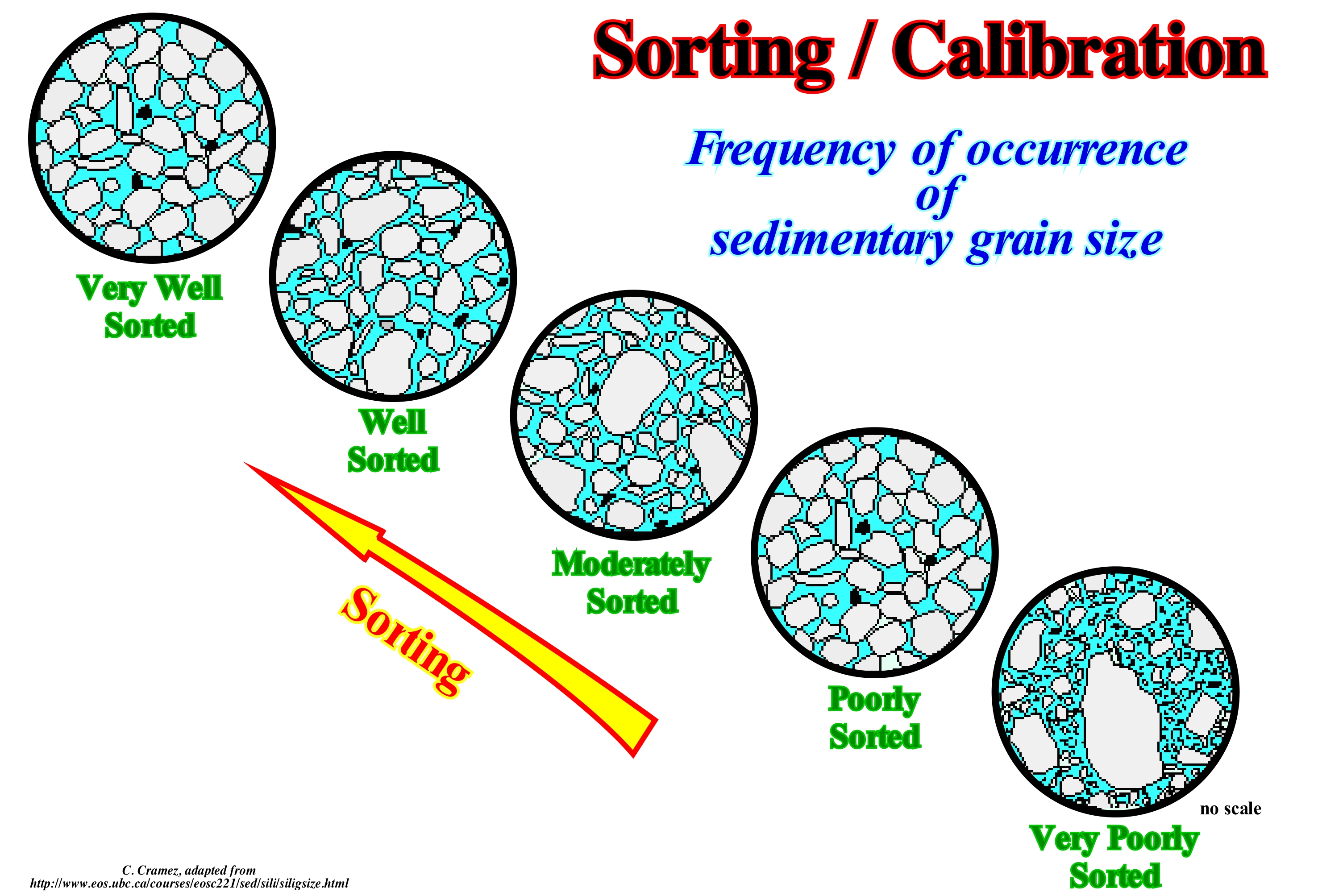
Sorting or calibrations (rounding, for certain geoscientists) is the degree of smoothing of a sedimentary particle due to abrasion. Calibration is expressed as the radius of the mean of the radii of curvature of the edges or corners of a sedimentary particle with respect to the radius of curvature of the maximum sphere that can be inscribed within the particle. As shown in this figure, sorting or calibrations is used to describe the shape of the corners of a sedimentary particle (clast), which may be a grain of sand, pebble, gravel, etc. Although sorting can be numerically quantified, for practical reasons, geoscientists generally use a simple visual chart with five rounding categories: (i) Very well sorted ; (ii) Well-sorted ; (iii) Moderately sorted ; (iv) Poorly sorted and (v) Very poorly sorted. Other geoscientists consider other divisions, for example: (a) Very Angular, with sharp and irregular corners ; (b) Angular ; (c) Subangular ; (d) Subrounded ; (e) Rounded and (f) Well Rounded, i.e., with the corners, completely, rounded. The calibration or sorting of the sedimentary particles indicates, roughly, the distance and the time involved in transporting the sedimentary particles from the area of origin to where they are deposited. The rate of sorting depends, of course, on the composition, hardness and cleavage of the mineral. For example, a soft clay particle is, obviously, more rapidly rounded and at a shorter transport distance than a quartz pebble, which is much more resistant. The sorting rate is also affected by grain size conditions and energy conditions. Abrasion occurs in natural environments such as beaches, sand dunes, river beds or any other current, as well as in association with the impact of waves, action of ice, wind, gravitational landslides and other erosive agents. Alluvial debris in large rivers tends to have a strong sorting degree.
Sorting (Grain-size)................................................................................................................................................................................Calibration (Sédiments)
Calibração (sedimentos) / Calibración (sedimentos) / Sortierung, Kalibrierung / 排序 / Сортировка / Calibrazione (sedimento) /
Dynamic process by which sedimentary particles with certain characteristics, such as: (i) Size; (ii) Form ; (iii) Density, etc., are, naturally, selected and separated from each other by the transport agents and particularly by the action of the water-courses (Bates, R. and Jackson, J.A., 1980).
See: « Granulometry »
&
« Gravel »
&
" Sedimentary Supply "
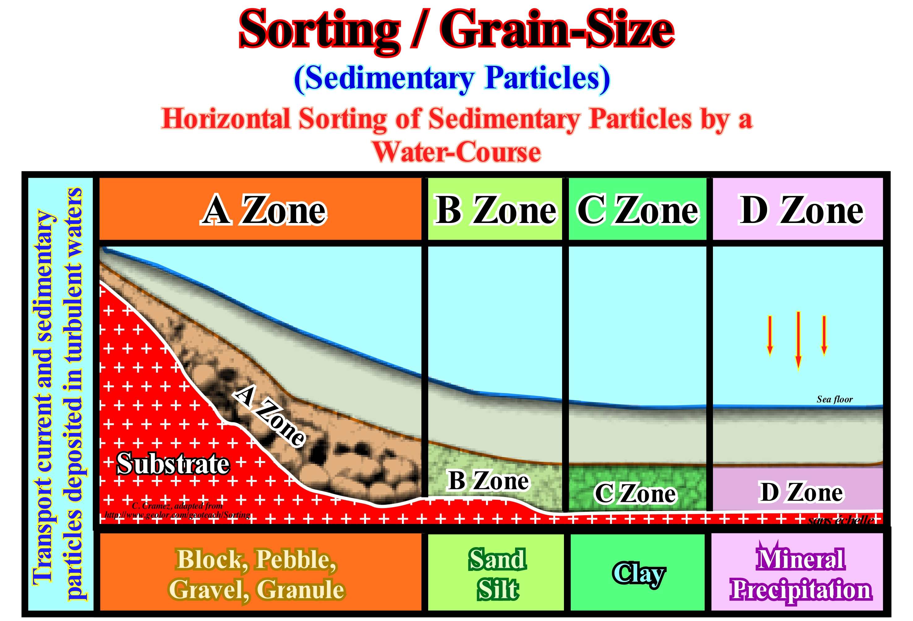
This diagram correlates the depositional zones with clastic sedimentary particles associated with a sorting (calibration) produced by a water-course . In A zone, the closest to the sources of the sedimentary particles, blocks, pebbles, gravels and granules predominate. In B zone, which lies, generally, at the base of the continental or deltaic slopes, sands and silts are predominant. In C zone, located in the deep parts of the sedimentary basins closest to the continent, shaly sedimentary particles are predominant. In D zone, which lies in the deepest parts of the sedimentary basins and further away from the mainland, the great majority of the sedimentary particles are deposit by precipitation rather than by transport. This sequence of sedimentary particles, as the current competence decreases, is observed very well in turbidite depositional systems. In a turbidite layer, a finning upward succession is always observed, which translates, practically, the sedimentary sorting shown in this figure. In order to understand the geological significance of sedimentary rocks, do not forget that all sedimentary processes, whether of weathering, transport or deposition, all work towards a common objective of obtaining a calibration of the three final products of all sedimentary processes, quartz (sand), clay (shale) and limestone (CO3Ca). So, to avoid confusion, never use the name of a mineral to designate a rock. The term clay, for instance, refers to a very fine mineral formed by feldspars weathering. It is the clay that muddy your shoes and it also muddies the water of a river or lake. However, when it deposits and compacts, it becomes a rock that geoscientists call claystone (shale) and not clay. A conglomerate, a breccia or a rudite are sedimentary rocks constituted by gravel, whether formed by blocks, pebbles or gravel. In the same way, a sandstone is sedimentary rocks formed by sand-like sedimentary particles, whereas a siltite and a shale are sedimentary rocks constituted by sedimentary particles of the mud type composed, respectively, of silt and clay. Do not forget that there are two types of sedimentary particles that when deposited become sediments: (i) Clastic and (ii) Precipitated. The former are associated the breakdown of rocks, and the second to the precipitation of organic or inorganic solutions.
Source (Seismic energy)......................................................................................................................................................................Fonte (Énergie sismique)
Fonte (energia sísmica) / Fuente (sísmica) / Quelle / 源 / Источник / Fonte /
Controlled seismic energy that is used in reflection and refraction seismics. The main sources of seismic energy used in the hydrocarbon exploration are dynamite, especially onshore, and airguns in offshore.
See: « Reflection Seismic »
&
« Angle of Refraction »
&
« Charge (seismic) »
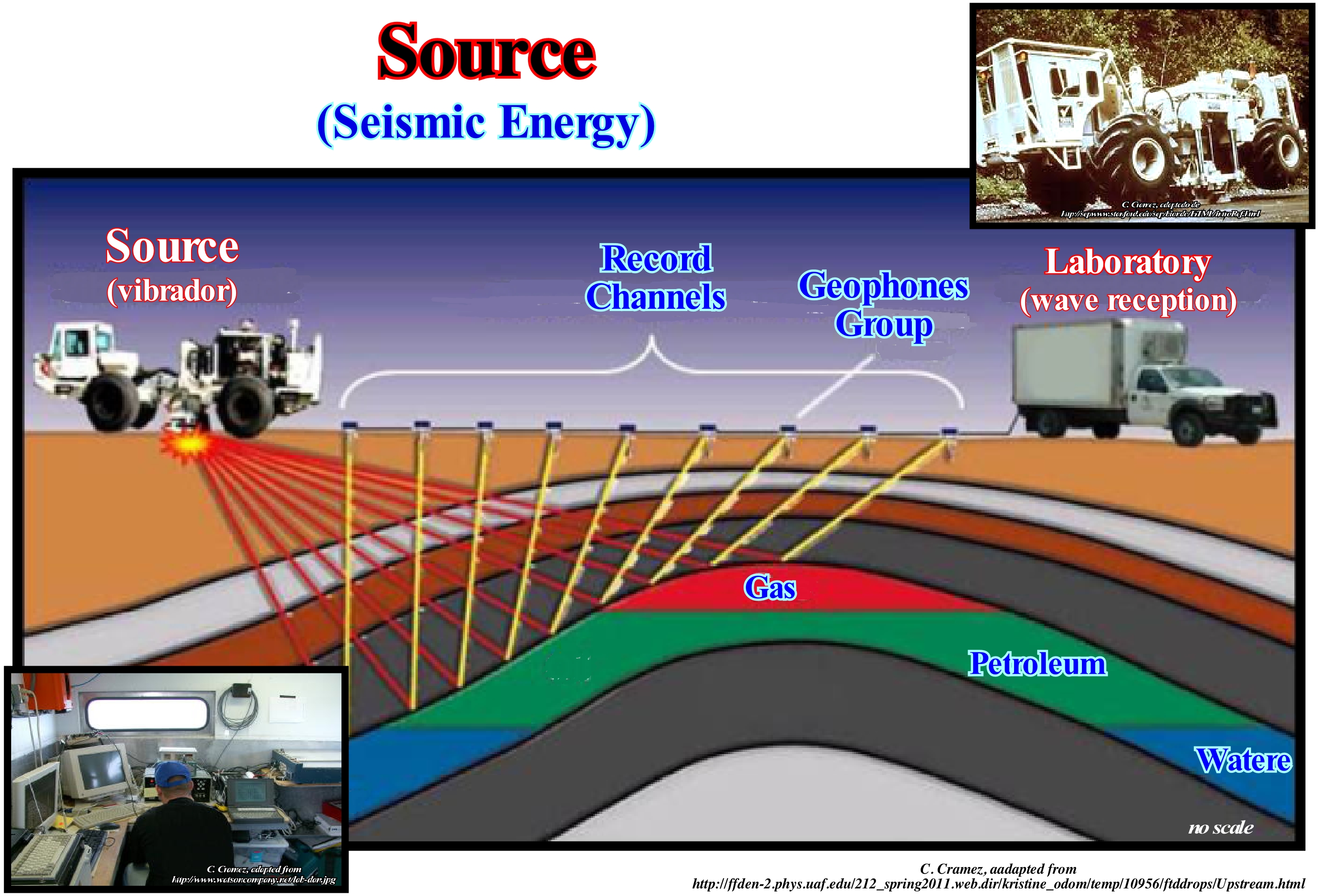
A seismic source generates controlled seismic energy, which is used in both seismic methods, i.e., in reflection seismic and in refraction seismic. The seismic source can be simple, like dynamite, or it can use more sophisticated technology, such as an air gun. Seismic sources can provide single pulses or continuous pulses of energy, which generate seismic waves that travel through a medium such as water or rock layers. Some of the waves are then reflected and refracted* to the receivers, i.e., to the geophones or hydrophones. Seismic exploration uses sound sources that can be used to investigate the shallow subsoil structure, for engineering work, deeper geological structures, usually, for petroleum exploration or for scientific research. Return signals from the sources are detected by geophones, located at known locations relative to the source position. The signals are recorded and subjected to expert analysis and processing to produce understandable data. The main types of seismic sources are: (i) Explosives ; (ii) Air gun ; (iii) Sound Source Plasma (PSS) ; (iv) Thumper trucks ; (v) Seismic vibrator; (vi) Booker Sources ; (vii) Noise Sources, etc. The air gun is composed of one or more tire chambers which are pressurized with compressed air at a pressure of 2,000 or 3,000 pounds per square inch (14 to 21 MPa). The thumper truck is a vehicle that produces an impact on the terrain, which can be used to produce a seismic wave. A weight of hundreds of pounds is lifted about 3 feet by a crane in the back of the truck and then dropped to the ground. Seismic vibrators propagate energy signals to the Earth over an extended period of time, as opposed to the almost instantaneous energy provided by the impulsive sources.
(*) Waves that have changed direction and velocity when they have passed from one medium to another with different refractive indexes, which occurs just if the wave is obliquely the separation surface of the two media and if they have different refractive indexes, which are given by the ratio n = c / v, where c is the speed of light in vacuum and the speed of light for a specific wavelength of the corresponding medium.
Source-Rock...................................................................................................................................................................................................................Roche-mère
Rocha mãe / Roca madre / Quelle Rock, Muttergestein / 烃源岩 / Нефтематеринская порода / Roccia fonte /
Sedimentary rock, rich in organic matter, which has been buried enough, so that its organic matter generated hydrocarbons in economical and profitable quantities.
See: « Sealing-Rock »
&
« Lacustrine Source-Rock »
&
« Reservoir-Rock »
On this tentative geological interpretation of a Canvas auto-trace of an Angola (Kwanza Geographic Basin) offshore seismic is illustrated a sour-rock interval, identified by exploration wells, which is rare in this offshore. Stratigraphically, this source-rock interval underlies the evaporitic interval (Aptian) of the divergent margin and overlyies the subaerial volcanism, which was, also, corroborated by several wells. This means that the source-rock interval is part of the lower sector of the divergent margin, i.e., it does not belong a rift-type basin, as is often the case this onshore and even in the offshore. The subaerial lavas (there is not significant submarine volcanic flows, since the lava under water solidify very rapidly) began to flow continentward from the expansion centres, immediately, after the breakup of the lithosphere, that is to say, since the individualization of the lithospheric plates of Africa and South America. The source-rock interval, illustrated on this tentative interpretation, was deposited during the first stages of the divergent margin and not during the development a rift-type basins. The least falsifiable hypothesis, that is, the one that best withstands the refutation tests, is that the sedimentary interval of the base of the margin, where the source-rocks are located, between the subaerial lavas and the top of the salt interval (base of the carbonates) was deposited in an epicontinental basin, shallow, or even in a large lake bounded between the expansion centre (westward) and the continent (eastward). It was probably in such a sedimentary environment that the organic-rich lacustrine shaly rocks, that constitute the source-rock interval, were deposited. Unfortunately, there is, practically, no evident traps in the infra-salt margin interval. All "structures" visible on this tentative interpretation correspond, most likely, to seismic pitfalls*. The lateral velocity changes, induced by salt thickness variations, induce, in time section, these type of pitfalls that do not exist in depth-version seismic lines. The hydrocarbon migration paths (note that the infrasalt sediments dip, continuously, toward north-west) and the presence of the salt, do not favour accumulations in the supra-salt sediments.
(*) Seismic anomalies are not related to geology. Their misinterpretation often lead to drilling results totally different from those expected.
Source Zone (Fluvial deposition)........................................................................................................................................Zone de fonte (Zf)
Zona de fonte (Zf) / Zona de fuente (Zf) / Source-Zone / 源区 / Зона возникновения очагов землетрясений / Zona de fonte /
One of the three sedimentological zones, evidenced by Emiliano Mutti, in a fluvial system: (i) Source Zone (Sz) ; (ii) Transport Zone (Tz) or transfer zone and (iii) Deposition Zone (Dz). It is in the source zone that most of the sediments are embedded in the fluvial current.
See: « Fluvial Deposition »
Space-Time................................................................................................................................................................................................................Espace-Temps
Espaço - Tempo / Espacio - Tiempo / Raumzeit / 时空 / Пространство-время / Spaziotempo /
Expression used by physicists to describe space in three dimensions and time dimension. The acceptance of Einstein's theories, in which space and time interact differently from that of Newton's physics, made the space-time expression very popular. However, it is perfectly correct to speak of space-time in the context of Newton's physics.
See: « Cosmological Time »
&
« Geological Time »
&
« GUT (theory) »
The concept of space-time combines space and time in a single "abstract" space, for which a unified coordinate system is chosen. Typically, three spatial dimensions (length, width and height) and a time dimension (time) are required. Dimensions are independent components of the coordinate grid required to locate a point in a given "space". On a globe, latitude and longitude are two independent coordinates that, together, determine a single location. In space-time, a coordinate grid, which encompasses 3 +1 dimensions, locates events (not just points in space), that is, time is added as another dimension in the coordinate grid. Coordinates specify where and when events occur. The uniqueness of space-time and the freedom of choice of coordinates allows the expression of the temporal coordinate in a coordinate system having temporal and spatial coordinates. In a normal coordinate system, there are constraints on how measurements can be made spatially and temporally. These constraints correspond to a particular mathematical model that differs from Euclidean space in its symmetry. Until the early twentieth century, time was thought to be independent of movement and to progress at a flat rate in all frames of reference. Later experiments revealed that time delays at high speeds ("time dilation", which explains the theory of "special relativity"). Several experiments have confirmed the dilation of time: (i) Atomic clocks aboard a spacecraft advance faster than on Earth ; (ii) The relative decay of the muons * of cosmic rays, etc. The time-duration may be different for several events in different frames of reference. When dimensions are interpreted as components of the grid system, rather than physical attributes of space, it is easier to understand alternative dimensions as simply the result of coordinate transformations.
(*) Subatomic particle of positive or negative charge and spin 1/2, which behaves like an electron, but is about 200 times more massive (105.7 MeV/c2). Both belong to the lepton family. The muon has a life span of about 1/1000000 of a second. It disintegrates in electrons (mass of 0.511MeV/c2) and in neutrinos. The muons are produced in accelerators, when collisions or disintegrations of other particles and when collisions of the cosmic rays. . As is the case with other leptons, it is not believed that the muon has any substructure, that is to say, that it has no simpler particles. (Trinh Xuan Thuan, 1998-Le Chaos et l'Harmonie, Gallimard).
Speculative Petroleum System (?).....................................................Système pétrolier speculatif (?)
Sistema petrolífero speculativo / Sistema petrolífero especulativo (?) / Spekulative Erdöl-System (?) / 投机性的石油系统 (?) / Спорная нефтегазоносная система (?) / Petrolio sistema speculativo (?) /
When the petroleum system is based just on geological or geophysical data, which has not yet been tested by exploration operations.
See: « Oil Pool »
&
« Source-Rock »
&
« Reservoir-Rock »
According to Magoon there are three types of petroleum systems depending on the degree of certainty: (1) Known Petroleum System (!), when the correlation between the source-rock and the hydrocarbons is well known and corroborated by the biomarkers, especially in the case of petroleum ; (2) Hypothetical Petroleum System (.), when there is a correlation between the source-rock and the hydrocarbons, but it has not yet been corroborated by the geochemical analysis (biomarkers) and (3) Speculative Petroleum System (?), when the system based on geological or geophysical data and the presence of hydrocarbons (oil or gas) not yet proven by wells. An oil system contains several parts that classify the fluid hydrocarbon system: (i) The source-rock ; (ii) The name of the rock-reservoir containing the largest volume of hydrocarbons and (iii) The symbol expressing the level of safety. Thus, in the example illustrated in this figure where no oil well has yet been made in the Chiru anticline, geoscientists advance a speculative (?) oil system, which can later become a hypothetical system (.), which geochemical studies can transform into a known system (!). An oil system has three important temporal aspects: (A) Age ; (B) Critical Moment and (C) Preservation Time. The age of an oil system is the time required for the generation-migration process and accumulation of hydrocarbons. The critical moment is the time that best portrays the generation-migration-accumulation process of hydrocarbons in an oil system. A map and cross section at the critical moment show the geographic and stratigraphic extent of the system. The burial story shows the critical moment and the essential elements of the oil system. The preservation time of a petroleum system begins, immediately, after the process of generation-migration-accumulation occurs and extends till today. It encompasses all changes in oil accumulations during this period. During the preservation time, re-migration, physical or biological degradation or complete destruction of petroleum may occur.
Speculative Reserves (HC).........................................................................................................................Réserves spéculatives (HC)
Reservas especulativas / Reservas especulativas (HC) / Spekulative Reserven (HC) / 投机性储备(慧聪) / Гипотетические запасы (УВ) / Riserve speculative (HC) /
Reserves that were not highlighted by exploration wells, but that certain geological and seismic data suggest the presence of the main petroleum parameters (trap, source-rock, rock-reservoir, maturation and retention) in the area.
See: « Reserves (HC) »
&
« Discovered Reserves (HC) »
&
« Proven Reserves (HC) »
At the time this geological map was drawn, the petroleum potential of the Bavush anticline, located in southern Iran (onshore), had not been tested by exploration wells, i.e., that no kind of uncovered reservations had been brought out. However, field studies (structural, stratigraphic, and geochemical) suggested the presence of an petroleum system in the area was plausible. A thick shaly sedimentary interval rich in organic matter was found in the field. Geochemical studies show that the shaly interval had been, sufficiently, buried and that organic matter had reached the oil window, which meant that there was, probably, an petroleum generating subsystem in the area. In the same way, several stratigraphic levels with petrophysical characteristics of rock-reservoir were identified and the structural map, made at these levels, showed a great probability of a significant structural trap (four-way-dip closure, like an anticline). Taking all these parameters into account, the geoscientists calculated a certain amount of speculative reserves (?). These speculative reserves were later tested by a exploration well, which turned some of the speculative reserves into proved reserves, another part into probable reserves and another into possible reserves. In given area and, particularly, in onshore, the presence of certain petroleum parameters: (i) Source-Rock ; (ii) Rock-Reservoir ; (iii) Trap ; (iv) Oil seeps, etc., allow geoscientists to advance, sometimes, a certain amount of speculative reserves, with a certain degree of confidence, which can later be tested with one or more research wells. It is these kinds of speculative reserves that the vast majority of small companies advertise with great pomp (and great exaggeration) when they acquire an exploration area or block, which in most of the cease, are never turned into discovered reserves. In general, at the beginning of exploration in a petroleum basin, such as the Gulf of Mexico or Kwanza onshore, the probability of discovery does not exceed 30-35%.
Spectroscopy.........................................................................................................................................................................................................Spectroscopie
Espectroscopia / Espectroscopía / Spektroskopie / 光谱学 / Спектроскопия / Spettroscopia /
Study of the interaction between radiation and matter, function of the wavelength. Historically, spectroscopy referred to the use dispersed visible light according to the wavelenght, as is the case, when light passes through a glass or crystal prism. At present, the concept of spectroscopy includes any measure of an amount as a function of wavelength or frequency.
See: « Snell's Law »
&
« Angle of Refraction »
&
« Flame Test »
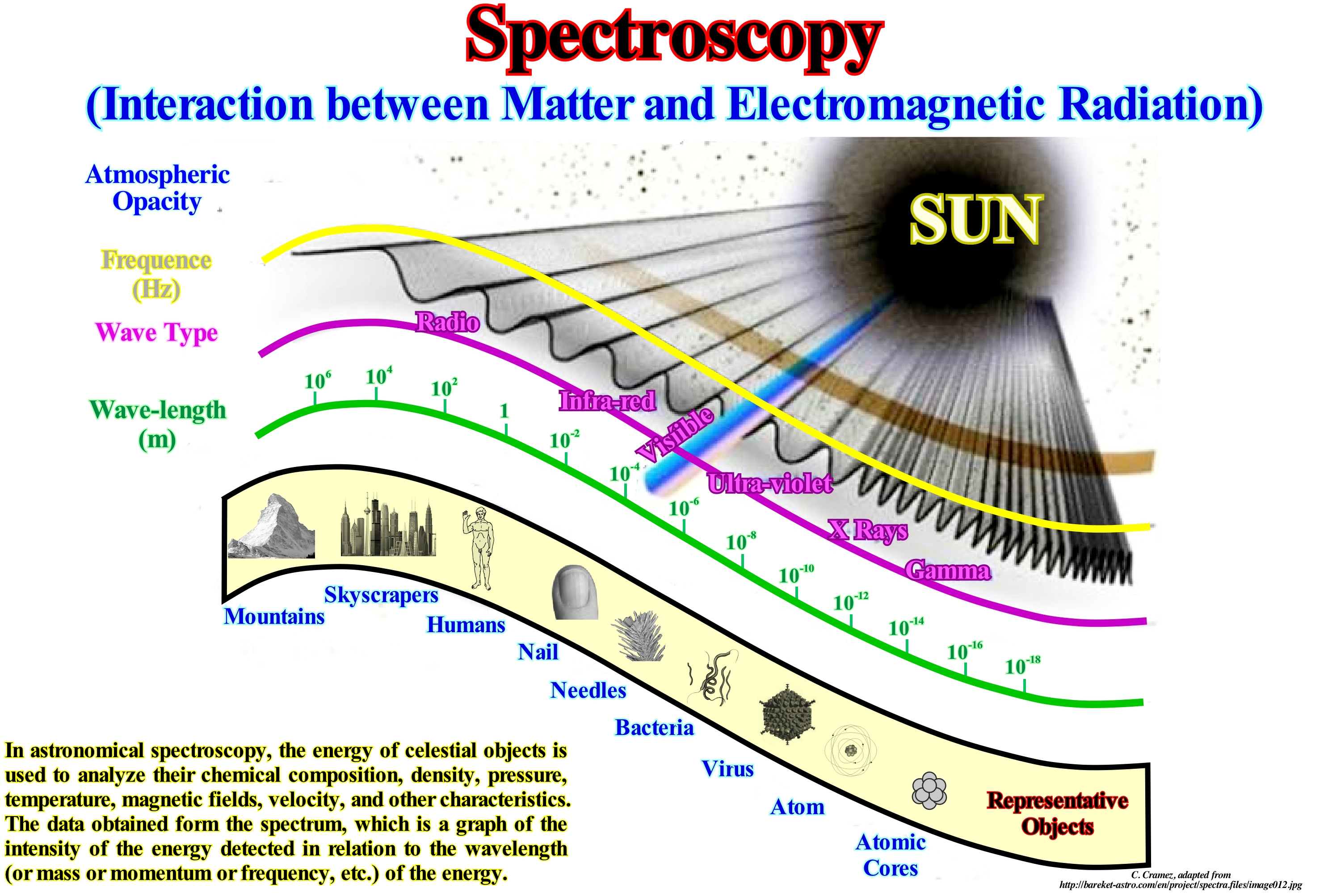
Spectroscopy is associated with the light scattering of an object in its component colours (i.e., energy). By performing such dissection and light analysis of an object, astronomers can determine the physical properties of the object (such as temperature, mass, luminosity and composition). The understanding of spectroscopy passes first and foremost through an understanding of light, which acts as a wave, but which also has properties of particles. The waves of light travel at the speed of light and the different lengths of the light wave manifest as different colours. The energy of a light wave is inversely proportional to its wave-length, or in other words, low energy waves have long wavelengths, and high energy light waves have small wavelengths. When we look at the Universe in a different "light" in a "different" way, that is, in a wavelength "not visible", we are probing different types of physical conditions and therefore we can see the new types of objects. High energy gamma rays and X-rays allow you to observe active galaxies and remains of massive stars, accretion of matter around black holes, etc., while visible light is best for observing the light produced by the stars. There are two distinct classes of spectra: (i) Continuous and (ii) Discrete. In continuous light is composed of a wide and continuous range of colours (energies). In a discreet spectra, we just see distinct light or dark lines with great definition of colours (energies). Discrete spectra with bright lines are called emission spectra, and those with dark lines are absorption spectra. In practice the focal point of the telescope's light beam is brought into the spectrometer's slit, which is finally captured by the detector. The light passing through the slit is then reflected in a collimation mirror, which parallels the beam of light, before sending it to a diffraction grid, which disperses the parallel beams of light in their component/length colours of wave/energy.
Speleogenesis......................................................................................................................................................................................................Spéléogenèse
Espeleogénese / Espeleogenésis / Speläogenese / Speleogenesis(起源和发展的洞穴) / Спелеогенез (генезис пещер) / Speleogenesi /
Origin and development of the caves in the carbonate rocks, i.e., the set of processes that determine the karst hydrology.
Ver: « Karst »
&
« Coastal Karst »
&
« Cave »
Speleogenesis is in the origin and development of the caves, i.e., the main process which determines the essential characteristics of karst hydro-geology and the principles of its evolution. As shown in this figure, most of the time, it deals with the development of caves in calcareous rocks, caused by the presence of water with dissolved carbon dioxide (CO2, producing carbonic acid, that allows the dissociation of the calcium carbonate of limestones. Water that flows through rock cracks around a cave can dissolve certain components, usually, calcite and aragonite (both are calcium carbonates) or gypsum (calcium sulfate). The rate of dissolution depends on the amount of carbon dioxide in solution, temperature and other factors. When the solution reaches a cave full of air, a discharge of carbon dioxide can alter the capacity of the water to keep these minerals in solution, causing their precipitation. Over time (tens of thousands of years), the accumulation of these precipitates can form speleothems that adorn the caves (not to be confused with speleogens, technically distinct speleothems, and which are formations within caves created by rock removal and not secondary deposits). The caves can be formed by various geological processes. These may involve a combination of chemical processes, erosion by water, tectonic forces, microorganisms, pressure, atmospheric influences and even excavation. Among the most well-known caves are: (i) The Lechuguilla cave, which, in 2006, was the fifth largest cave in the world (± 193 km) and the deepest in the continental United States, but it is famous for their geology ; (ii) Skyline caves, located in Virginia, which are one of the only places on Earth, where anthodites can be observed (the term anthodite was quoted in the scientific literature for the first, in 1965 by Kashima to describe a speleothems similar to flowers composed of alternating calcite and aragonite) ; (iii) The Ogof Craig Cave, which is perhaps the most well-decorated cave in Britain.
Speleothem...................................................................................................................................................................................................................Spéléothème
Espeleotema / Espeleotema / Speläothem / 石笋 / Спелеотемы / Speleotema/
Secondary mineral deposit formed in a cave, such as stalactites or stalagmites.
See: « Cave »
&
« Stalagmite »
&
« Grotto »
Speleothems can take many forms, depending on whether water drips, exudes, condenses, leaks, or forms small ponds. Most speleothems are named for their resemblance to natural or man-made objects. The main types of speleothems are: (i) Stalactites; (ii) Spirocones and Corkscrew ; (iii) Helictites and Heligmites ; (iv) Curtains; (v) Stalagmites; (vi) Flowstones (Drainings) ; (vii) Flowers and Needles, etc. Spirocones and corkscrews are special types of spiral-shaped or corkscrew stalactites. Helictites and heligmites are speleothems formed from the ceiling or the walls (helictites) or from the ground (heligmites), by a process that is, initially, similar to that of stalactites, but rather than forming vertically towards the ground, deviate to the sides or even up. The curtains are formed when the roof is tilted and the water that arrives through the gaps does not drip, vertically, but it escapes following the curvature of the ceiling and walls. The flowstones form when water, which flows through the walls or around older columns and stalagmites. One of the most common forms is the organs, similar to groups of stalactites stuck to the walls. There are also stone waterfalls. Other forms of runoff may create discs or sheets projected from the walls, chandeliers or pendants on the ceiling, and stalagmite plates, which accumulate on the ground covering large areas instead of rising vertically. Exudation can create droplets, bubbles, and other forms collectively called coralloids. Some speleothems may have formations similar to small stalactites that grow side by side, called dog teeth. The needles are thin tubes made up of transparent aragonite, with a very small thickness. They occur in sets with tens or hundreds of needles next to each other. They may be born on the walls on the floor, rarely, on the ceiling, as a result of exudation. The flowers are composed of aragonite, but also occur in gypsite and calcite. They are made up of hundreds of crystals that radiate from a central point. They can also make curls, radiated from an axis that can move in several directions like the stem of a bunch of flowers. The size of growth variations of stalagmites can be determined by the thickness of the intervals deposited annually, either in natural light or in excitation of their luminescence* by ultraviolet radiation. The growth velocity of stalactites and stalagmites is, generally, a function of precipitation, so it can give interesting information about precipitation. For significant time intervals, the growth rate of these calcareous concretions can be determined by U/Th dating made at different levels of these concretions.
(*) Emission of light by a substance when subjected to some type of stimulus such as light, chemical reaction, ionizing radiation, etc.
Spit...............................................................................................................................................................................................................................................................................................Flèche
Cabedelo (restinga) / Restinga / Haken / 细雨, 箭头 / Стрела, коса (длинная отмель) / Lingua di terra /
Barrier bar with one free end, called the tip of the stip, and the other against the coast. A spit is often formed by the growth of the prélitorial ridges and / or the shoals of estuaries and deltas by the currents of drift and tides. Synonym with Tongue.
See « Shoreline »
&
« Beach »
&
« Middle Sea Level »
Taking into account the results of the endogenous processes (processes that take place inside the planet Earth) and exogenous (processes that use the energy coming from outside the Earth, basically, the solar energy that acts directly or indirectly on the surface of the crust) that affect the formation of the coast (the boundary between land and sea that is, permanently, subjected to erosive agents), can be classified as: (i) Rugged Coasts with abrupt cliffs ; (ii) Flat Coasts that have a smooth slope and (iii) Equilibrium Coasts, formed by displacement of the initial coast. On the coast displacements, at the mouth of a river with estuary, the discharge of, more or less, coarse sediments, when affected by the sometimes contradictory movements of the river current and sea currents, can construct (if the continental shelf is slightly sloping), a barrier bar or spit ("lido" in Italian, "nehrung" in German). Certain geoscientists define a spit as such a barrier or wall of sand that is built over a relatively long time on the human scale and plays an important morphological role. Probably, the term "cabedelo" (spit in Portuguese) comes from the name of the municipality located in the state of Paraíba (Brazil), which has a singular spit form, with 18 km long by 3 km wide, in which the large majority of the population (around 500,000 people) live. A spit can be considered as a coastal barrier bar with a free end, that is, with a tip. The other end is supported against the shore. In general, a spit is formed by the growth of the longshorerunnels* and / or of the sand banks of the estuaries and deltas, by the action of the littoral currents (longshore drifts) and of tidal currents. The tip of the spit can have very varied forms, which translate the vectorial resultant of the currents. In general, the tip has a rounded shape in hooked due to diffraction of the waves, as shown in this figure. When there is erosion in the base (or in the body of the spit) the tip migrates forming several hooks. When two spits converge in V, they delimit a lagoon or a marsh of triangular form. When a spit develops in the extension of an island, as a tongue of sand or pebble, it is said that the spit is shaped like a comet tail (Moreira, 1984). In this figure is illustrated one of the spits that characterize the Quebec (Canada) coastline, that form in front of the river mouths (in this case of a small river that empties in the great river of Saint Lawrence). This type of spit represents approximately 5% of the Quebec coast. These sandstones correspond to accumulations of sand connected to the coastline. In general, it can be said that they are elongated, more or less, parallel to the shoreline and with a loose end, which means that it is not connected with the opposite end. On certain rocky platforms composed of gravel, the sandbanks may be oriented perpendicular to the shoreline. For Portuguese and Angolan geoscientists, talking about spits and not mentioning the Luanda spits and the "Mussulo island", which, by the way, it is not an island, but a magnificent spit, would make little sense. In the same way, among others we can cite: (i) The Dungeness spit, in the state of Washington (USA) ; (ii) The spit of the Golden Tip (Zlatni Rat) in the Adriatic Sea (Croatia) ; (iii) The Olu Deniz spit in Turkey ; (iv) The Farewell spit in the Golden Bay in New Zealand and, of course, (v) The spit of the beach in Courland, Lithuania, which UNESCO designated as World Heritage in 2000, although it is, normally, considered one of the spit Lithuania, is also part of the region of Kaliningrad ** (Russia). The best known area of this spit (only 2 km wide and 98 km long) is arguably Nida beach, which in summer is one of the favourite places, if you can see architectural and cultural remains of the ancient tribe Kursiai who lived in the Neringa spit (local name) and who fed a number of fairy tales and mysticism over the centuries to the Lithuanian people. The Long Point Spit is the longest spit on a freshwater body and extends for about 40 km from the northern shore of Lake Erie in Ontario, Canada. The spit is 1km wide at its widest point.
(*) At the outer boundary of the surface of the shoreface (low-tidal terrace) large ripples can form, which can reach one meter, constituting what the geoscientists call pre-littoral ridges (longshore ridges or longshore bars) and pre-littoral troughs (longshorerunnels)
(**) Capital of the homonymous Russian province, Russian enclave between Poland and Lithuania, on the edge of the Baltic Sea. Famous for having among its inhabitants the philosopher Emmanuel Kant, and for the well-known problem of Kalinigrad' seven bridges, that Leonard Euler, the eminent Swiss mathematician of the 18th century, solved in 1736.
Spit of Junction....................................................................................................................................................................................................................Flèche (De junction)
Cabedelo de junção / Restinga de unión / Haken (Kreuzung) / 箭头(结) / Соединительная коса / Lingua di terra (incrocio) /
Small passage of sand or gravel that connects an island to the mainland or to another island. Synonym of Tombolo.
See « Shoreline »
&
« Beach »
&
« Spit »
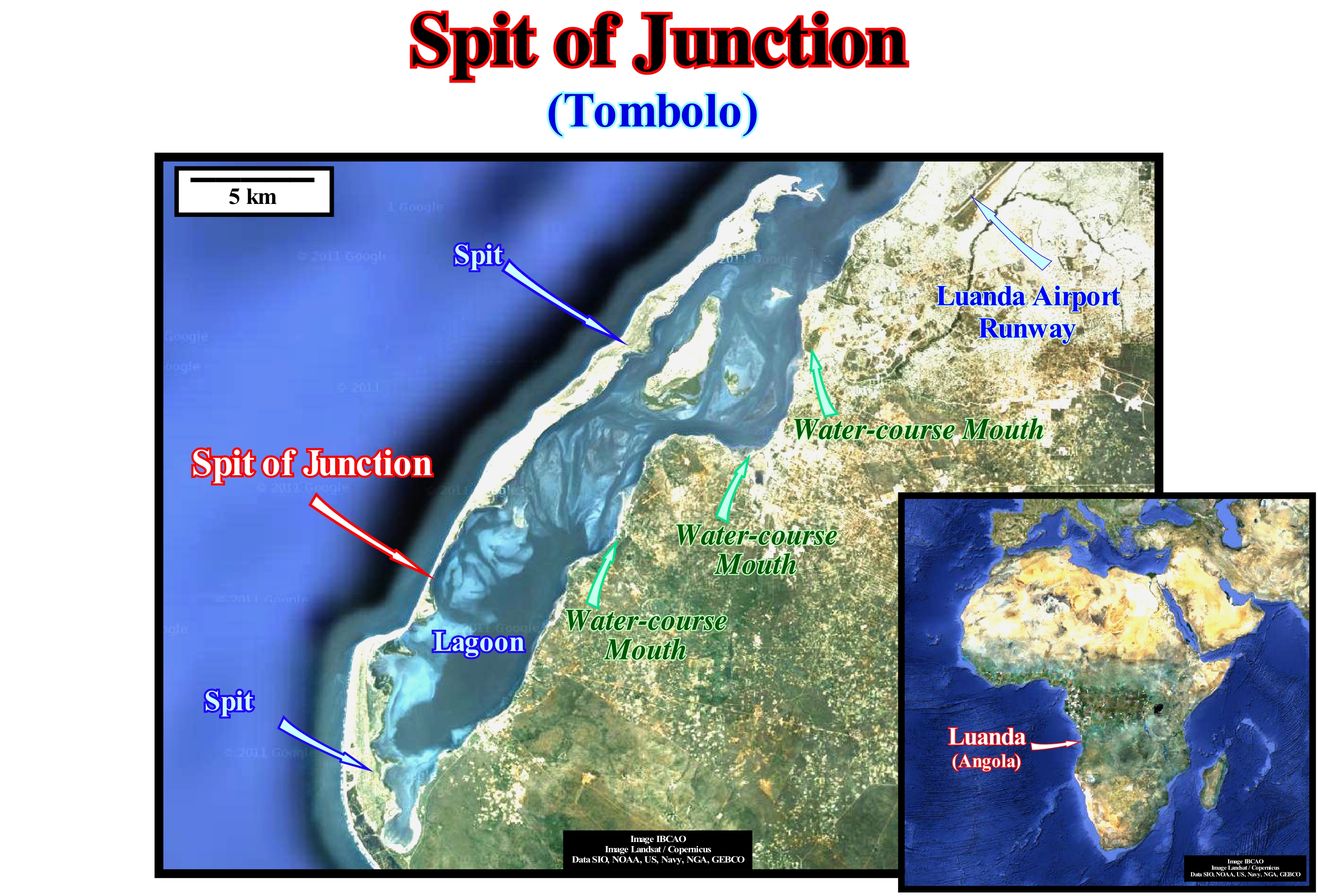
As illustrated in this figure, the spit of Luanda (Angola), better known as Luanda Island, probably formed in association with the Benguela marine current. It is more than 30 kilometers long and has a width ranging from tens of meters to one kilometre. Its orientation is at least parallel to the coastline and the water slide between spit and the mainland, as can be seen in this photograph, decreases, gradually, as the sediments settle, either in association with small current, or with overbanking. The two large spits (islands) are connected by a narrow junction. These coastal barriers, which are built up, little by little, for a relatively long time play an important morphological role. In general, in almost all spits, it is possible to be observed that behind the coastal barrier bar, the sea isolates, more or less, a lagoon, in which fluvio-lacustrine sediments are deposited that tends to fill it. The lagoon can present in several stages: (i) Lagoon (sometimes with salines) ; (ii) Lower mud-flat or slikke (sludge or low-tide platform) ; (ii) Tidal-flat, Upper mud-flat, Schorre ; (d) Polders (salt marshes conquered by salt marshes, pastures and forage and rice cultivation), and finally (e) Mainland with few marine incursions, but may be quite marshy. The evolution of these stages is different from the evolution of a delta, which develops in similar conditions, since a delta implies the subsidence of the continental shelf. Whereas if the lagoon exists, at least in part, the current of the initial river changes to find an exit through the barrier bar (openings, inlets"). The coastal barrier-bar is subjected to the special coastal zone climate over which dominated wind actions. It serves as point of support for the dunes and the sandy beaches. If the coast has small islands, the coastal barrier bars can join these islands to the coast contributing to increase the surface of the islands as is the case illustrated in this photograph. The formation of such a coastal barrier-bar (often called tombolo), which may be simple or composed (double or triple), as they are formed by one or more barrier-bars, is due solely to the play of waves and marine currents. In the composite tombolos lagoons can form between the coastal barrier-bars.
Spring (Stream).................................................................................................................................................................................................Fontaine (Cours d'eau)
Nascente (curso de água) / Fuente (corriente) / Feder (Fluss) / 春天(河) / Источник (ключ) / Fontana, Sorgente (fiume) /
A spring is a source of water coming from the Earth, which, usualy, stays in one location, A source is the place in a river or stream where water springs. A source is different from a spring. A spring is the place, on the Earth surface, where groundwater is born, that is to say, that springs, naturally, to surface.
See: « River »
&
« Debris Flow »
&
« Juvenile Water »
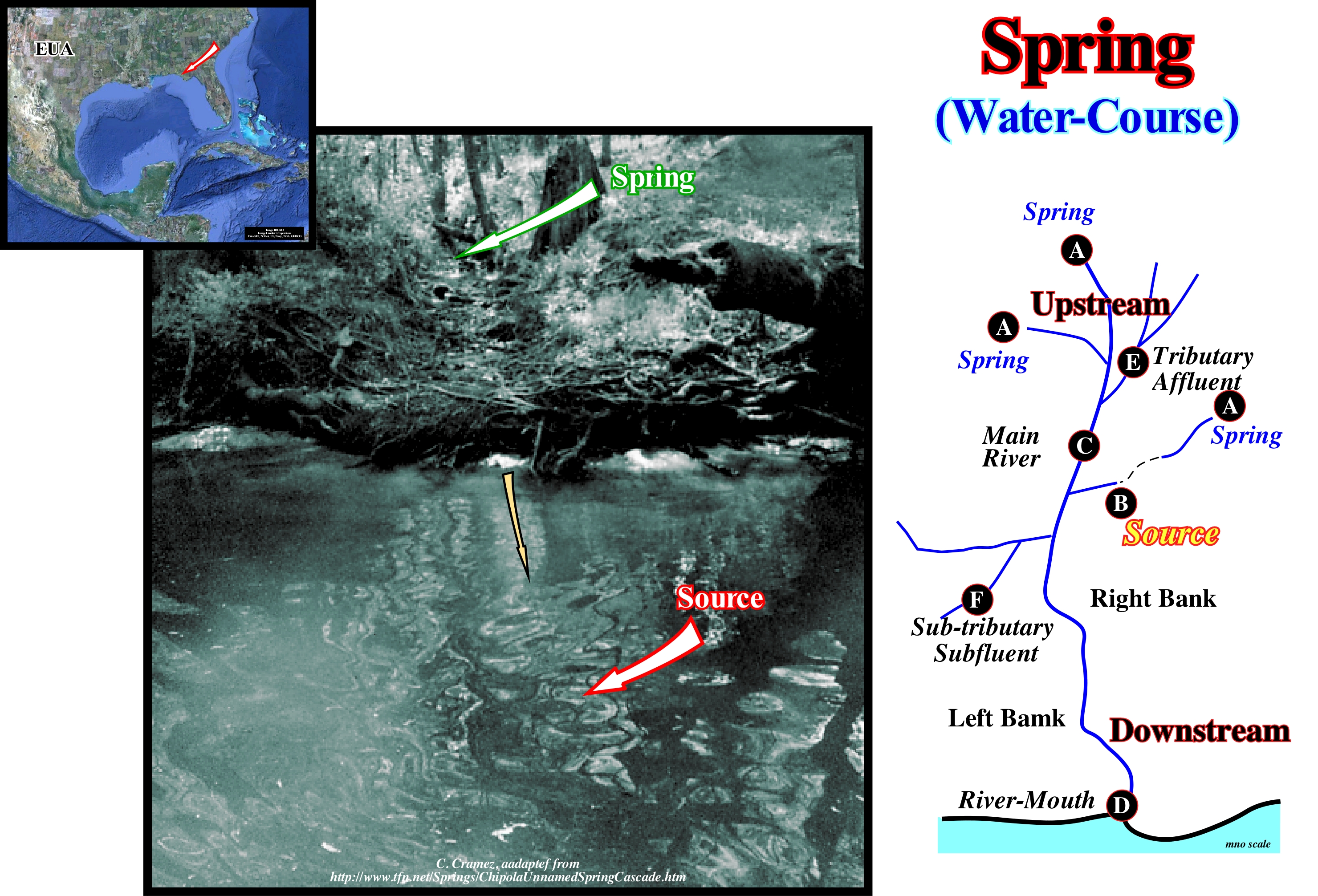
This photograph illustrates a spring (green arrow) and not a source (the swirl in the river is caused by the water coming in from the spring). This spring is located in Florida (USA) and is particularly known to Americans because of their interest in the history of their country. The spring is located on the west bank of the Chipola River (N 39 ° 44 '70.8 W 85° 12' 90.3"), between two old houses that during the War of Independence were used by the Confederates who drank the water of the (the old dwellings are not visible in this photograph, but they are about ten meters from each side of the spring). As can be seen in this photograph, the water that flows from the spring falls from the riverbank. The water flow, which is around 8 l/s creates a small creek and a whirlwind (maelstrom or circulatory movement of water). Many geoscientists use the terms spring and source as synonyms. In the Priberam dictionary, a source (fountain) is a spring of water and a spring is the place where a stream of water or fountain flows. In the dictionary of the Academy of Sciences of Lisbon, one can read "source or fountain-place from which water springs from the ground = spring." In geology, and particularly in Hydrogeology (study of the distribution and movement of groundwater in the soil and rocks of the Earth's surface), the terms source (fountain) and spring designate different things, though related to each other. A source is the place on a river or any other current where water (usually subterranean) is exhumed (sprouted). A spring is the place, on the ground and not in a body of water, where the groundwater is born, that is, the place where the surface of the aquifer intersects the surface of the Earth. When a geoscientist refers to the spring of a river, he is referring to the point of the drainage basin furthest from the mouth and where the groundwater flows, which means that along a river there may be several sources and, only the most upstream source is that it corresponds, in fact, to the spring of the river. It is this definition of the A. Johnston geographer of the Smithsonian Institute that was used by the National Geographic Society of the USA to locate the source of most rivers.
Spring Tide...........................................................................................................................................................Marée de vives eaux (Grande marée)
Maré viva (grande maré) / Marea viva / Springflut / 大潮 / Сизигийный прилив / Marea equinoziale /
Tide that occurs during the syzygies* and that is characterized, for each place, by the maximum amplitudes.
See: « Syzygy »
&
« Tide »
&
« Neap Tide »
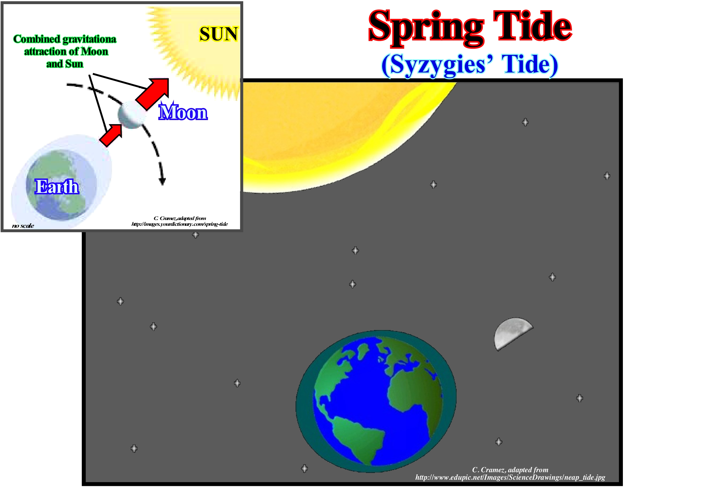
The word "tides" is a generic term used to define the alternating rise and fall of sea level relative to Earth, produced by the gravitational attraction of the Moon and the Sun. In a less significant way tides also occur in large lakes, atmosphere and within the Earth's solid crust due to the same gravitational forces of the Moon and the Sun. Tides are created because Earth and Moon are attracted to each other as two magnets are attracted to one another. The Moon tries to pull all things on Earth to her. But, the Earth is able to retain everything except water. Since the water is always in motion, the Earth can not grasp it, and thus the Moon pulls her. Every day there are two high-tides and two low-tides. The ocean is, constantly, moving from high-tide to low-tide, and then back to high-tide. There are about 12 hours and 25 minutes between the two high-tides. Tides are the periodic rise and fall of large bodies of water. Winds and currents displace the surface of the water, causing surface waves. The gravitational pull of the Moon causes the oceans to deform toward the Moon. Another symmetrical deformation occurs on the opposite side, as the Earth is also being drawn to the Moon. The level of the oceans varies daily, when the Sun, Moon and Earth interact. As the Moon travels around the Earth and as they travel together around the Sun, gravitational forces combine to force the world's oceans to rise and fall. As the Earth rotates, as it happens, two tides occur each day. When the moon is full or in new moon, the gravitational pull of the Moon and the Sun combine. On these occasions, the high-tides are very high and the low-tides are very low, which is usually known as spring tides. In fact, spring tides occur when the Earth, Sun and Moon are in line. The gravitational forces of the Moon and the Sun, instantly, contribute to the tides. In other words, spring-tides occur during the full moon and new moon phases. During the first quarter and third quarter of the Moon, the Sun and Moon are perpendicular, which causes the deformations to cancel out. The result is a very small difference between high and low-tides, which geoscientists call quadrature tides or neap tides.
(*) In astronomy, syzygy designates the alignment of three celestial bodies belonging to the same gravitational system forming a rectilinear configuration, which in this particular case are the Earth, Moon and the Sun.
Stable Continental Craton (Wilson's cyle)................................................................Craton continental stable
Cratão Continental Estável / Cratón Continental estable (ciclo de Wilson) / Stabile kontinentalen Kraton / 稳定的大陆克拉通 / Устойчивый континентальный кратон / Cratone continentale stabile /
The first and last tectono-stratigraphic phase of a Wilson's cycle: (i) Stable Continental Craton ; (2) Thermal Anomaly (hot spot) and Lengthening (rifting) of the craton, with formation of rift-ype basins (usually halfgrabens with opposite vergence on each side of the thermal anomaly) ; (3) Breakup of the Lithosphere, with creation of new oceanic crust and formation of two divergent margins ; (4) Oceanic expansion (sea floor spreading), which little by little transforms the young margins into mature margins due to the cooling and increasing density of the oceanic crust ; (5) Subduction : since the density of the oceanic crust is very important, it is divided in two parts and one of them plunges (under the other one) creating a convergent margin and the formation of a volcanic arc and the uplifting of a mountain range on the overriding lithospheric plate ; (6) Divergent Margin/Volcanic Arc collision, forming a Folded Belt ; (7) Peneplanation (folded belt) and new subduction of the oceanic crust with the twin margin creating another convergent margin ; (8) Continent/Continent collision and Closure of the Ocean created between the two initial divergent margins and (9) End of the Wilson's cycle with the formation of a New Stable Continental craton.
See: « Wilson's Cycle »
Stage (Geological).........................................................................................................................................................................................................Étage (Géologique)
Andar (geológico) / Estadío (geológico) / Stufe (Geologie) / 第一阶段(地质) / Геологический ярус (горизонт) / Stage (geologia) /
Chronostratigraphic interval intercalated between a "series" and a "substage" and which is characterized either by a succession of biostratigraphic zones (considered as chronostratigraphic deposits) or by the rocks deposited during the respective geologic time (Bates, R.L. and Jackson, J.A., 198).
See: « Geological Time Scale »
&
« Geological Time »
&
« Relative Time »
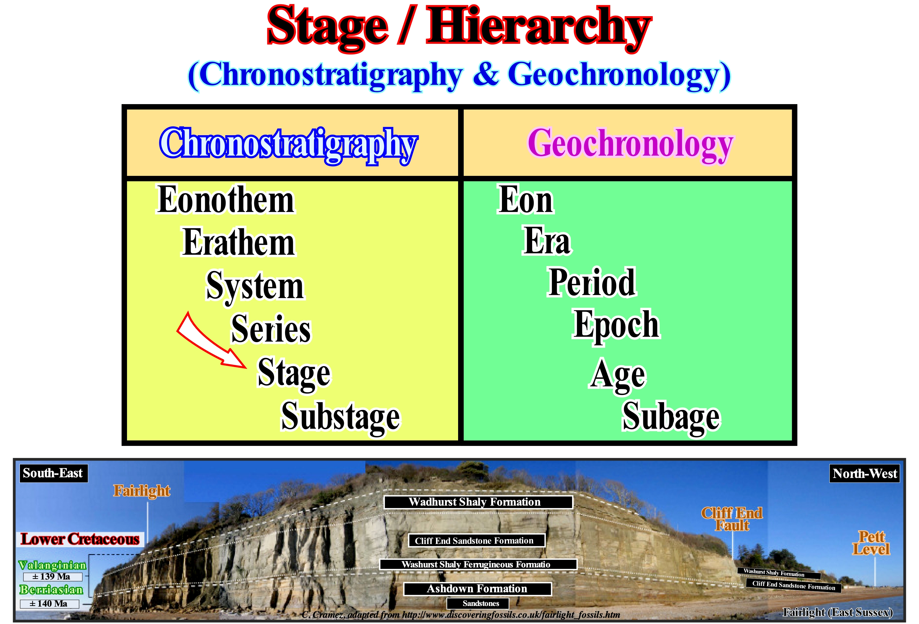
A stage is the chronostratigraphic equivalent (set of rocks) of an age, which is a geochronological unit (time). This differentiation is very important, but it is often overlooked by many geoscientists who continue to use, completely, different terms as synonyms. In certain official geological maps it may be seen, for example, that the terms Cretaceous Upper and Late Cretaceous are used as synonyms, when in fact they designate, completely, different things. The Upper Cretaceous refers to the rocks deposited during the Late Cretaceous, which is a time interval. In addition, the Late Cretaceous geologic time period does not correspond to the sum of the deposition time of the Upper Cretaceous rocks. The effective time of deposition of the rocks of a chronostratigraphic unit is always much smaller than the time of the geochronological unit. This means that for most of geological time nothing happens. Imagine a stage (chronostratigraphic interval, that is, a set of rocks) limited by two unconformities (erosional surfaces induced by significant relative sea level falls). The lower unconformity 10.5 Ma (millions of years ago), while the upper unconformity is 8.2 Ma. The depositional systems that form this sedimentary interval are submarine basin floor fans (SBFF). The geochronological interval is 2.3 My (millions of years) and, in terms of sequential stratigraphy, it corresponds to a stratigraphic cycle induced by a 3rd order eustatic cycle (time-duration between 0.5 and 3-5 My) called sequence-cycle*. However, the sum of the actual depositional time of this chronostratigraphic interval is perhaps less than 100 ky. The depositional time of each turbidite layer is, geologically, instantaneous, whereas the time-interval between each turbidite current can be over 1,000 years and that during all this time, practically, nothing happens at the stratigraphic point of view, which means that there is no deposition.
(*) Such a sequence-cycle is incomplete since the highstand systems tracts groups (HPW plus TI) were not deposited as well as the upper lowstand systems tracts sub-groups, i.e., the lowstand prograding wedge (LPW) and the submarine slope fans (SSF).
Stalactite........................................................................................................................................................................................................................................Stalactite
Estalactite / Estalactita / Stalaktit / 钟乳石 / Сталактит / Stalattite /
Crystalline rock suspended from the caves vault (usually on limestone rocks) created by a partial evaporation of drops of water falling from the ceiling.
See: « Stalagmite »
&
« Limestone »
&
« Cave »
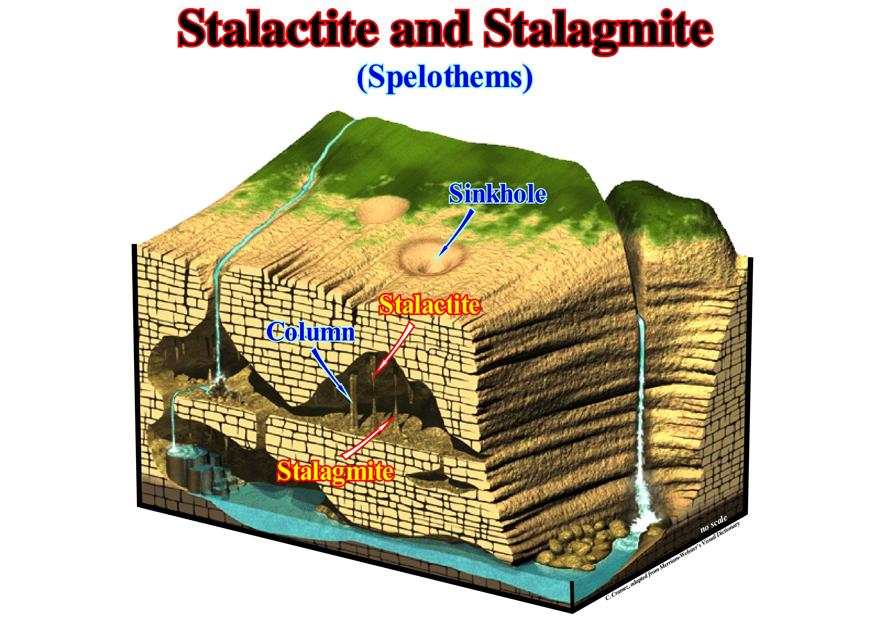
Stalactites are speleothems, that is, mineral deposits from caves resulting from sedimentation and crystallization of minerals dissolved in water. They are found in all limestone caves and are formed by drops of water falling from the ceiling. In fact, the water, upon contact with the air of the cave, releases part of the dissolved CO2 and precipitates a ring of calcite at the base of the drop. As more calcite precipitates, a hollow, elongated tube forms, which can reach several meters in length and a few centimeters in diameter. Over time, a stalactite increases in diameter, as the water from the ceiling flows down the outside, precipitating more calcite. This increase in thickness is done from top to bottom, which gives it a conical shape. Stalactites in spiral form are called spirocones or stalactites in corkscrews. They form when the main channel of the stalactite becomes clogged and water is forced to seek other paths through the walls of the tube or root. The runoff from the outside causes the stalactite to become thicker near the root. On the other hand, the irregularities of the stalactite cause the water to flow in spirals creating the characteristic shape in the corkscrew of these stalactites. The speleothems formed from the ceiling or walls are called helictites and those formed from the ground are called heligmites. The process is initially similar to that of stalactites, but instead of forming vertically toward the ground, such as stalactites, they deviate sideways or even upwards. When the roof of a cave is tilted, the water when it reaches the crevices does not drip vertically, but it flows along the slope of the ceiling and walls, and the precipitation of the minerals produces curtains with a thickness ranging from a few millimeters to several centimeters. These deposits called curtains can make bifurcations or join together in more or less complex sets. In some old caves, the curtains can reach the floor and may even close some galleries. When curtains are formed with sedimentary layers of various colours, speleologists call them "slices of bacon," since they look like slices of bacon. The measure of growth variations of stalagmites can be determined by the thickness of the intervals deposited annually, either in natural light or in excitation of their luminescence* by ultraviolet radiation. The growth velocity of stalactites and stalagmites is generally a function of precipitation, so it can give interesting information about precipitation. For significant time intervals, the growth rate of these calcareous concretions can be determined by U/Th dating made at different levels of these concretions.
(*) Emission of light by a substance when subjected to some type of stimulus such as light, chemical reaction, ionizing radiation, etc.
Stalagmite...............................................................................................................................................................................................................................Stalagmite
Estalagmite / Estalagmita / Stalagmit / 石笋 / Сталагмит / Stalagmite /
Concrete or limestone more or less tubiform formed on the ground of the subterranean cavities by the slow fall and evaporation of the waters that fall from the vault.
See: « Stalactite »
&
« Limestone »
&
« Cave »
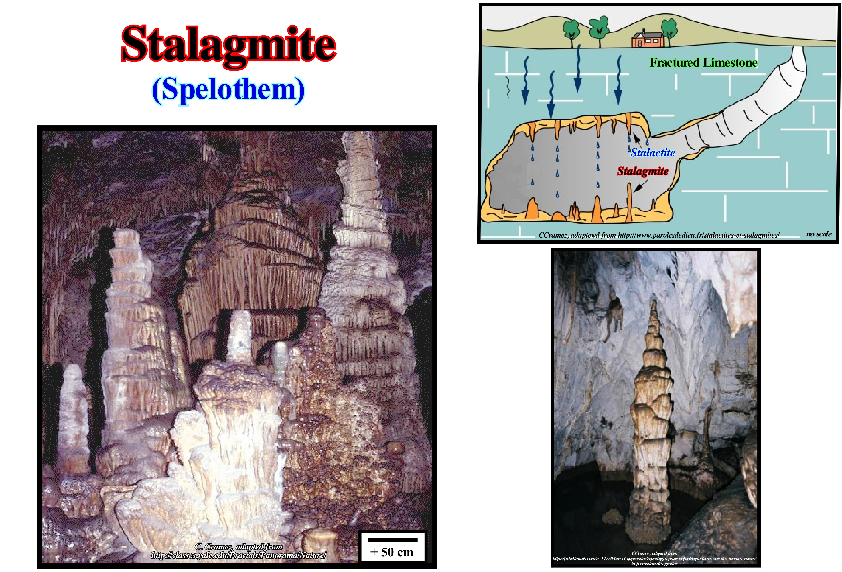
As illustrated in this figure, stalagmites are formations that grow from the floor of a cave or cave and that go towards the ceiling. They are formed by the deposition (precipitation) of calcium carbonate from the water falling from the ceiling. Unlike stalactites, stalagmites are formed from below by the growth of successive layers of small, elongated crystals of calcite, oriented more or less perpendicular to the growth surface. The stalagmites can have different forms: bulbous, flattened, columnar, etc., and sometimes with very irregular forms, which contrasts with what happens in stalactites. The growth rate of stalagmites can be determined by the thickness of the intervals deposited annually, either in natural light or in excitation of their luminescence thanks to ultraviolet radiation. As the growth of stalagmites is, in general, a function of rainfall, it can give interesting information. For large time intervals, the growth rate of stalagmites can be determined by U/Th dating at different levels of these concretions. The junction of a stalagmite with a stalactite forms a column. Many stalagmites can be dated (absolutely) since sometimes isotopes (atom having the same atomic number as another, but a different mass number) radiatively replace calcium. The rate of disintegration of the parent isotopes into sons isotopes allows us to calculate the age of deposition, which allows us to date certain fossils and archaeological objects in an indirect way. Hackley et al. (2008), used stalagmites as a dating base not only for southern Illinois caves, but also for earthquakes in the area. They found that some of the youngest stalagmites began to form only after 1811/1812, i.e., after the great earthquake in New Madrid (USA). Water filled with calcium carbonate dripping through the cracks in the ceiling falls to the floor and a stalagmite begins to slowly grow. Time can be measured by alternating light and dark layers, where each pair represents one year. When an earthquake affects a region, the old bills can be closed and new formed. As a result, the water flowing in the basement ceiling may deviate from the initial path and eventually form new stalagmites. In this way, it is possible that each new generation of stalagmite underlies an earthquake. In addition to the earthquake of 1811/12, this methodology allowed to recognize at least 7 other earthquakes in the last 18,000 years.
Standard Carbonate Facies Belt............................................................................................Modèle (Ceintures carbonatées)
Padrão (cinturas ambientais carbonatadas)/ Modelo (fajas de facies carbonáticas) / Standard-Carbonat-Fazies Gürtel / 标准的碳酸盐岩带 / Пояс карбонатных фаций / Standard facies carbonatiche cinture /
Regardless of the time and geological context, shallow water carbonates tend to form similar belt patterns. From upstream to downstream, the following environment sequence is often observed: (9) Evaporites in saline sabkhas; (8) Restricted circulation platform and tidal plain; (7) Platform lagoon with open circulation; (6) Winowed edge sands ; (5) Platform reefs; (4) External slope; (3) Deep shelf margin ; (2) Open sea platform and (1) Basin.
See: « Sabkha »
&
« Deposition (carbonates) »
&
« Relative Sea Level Change »
This figure illustrates a more or less typical succession of the shallow-water carbonate belts, in which the following patterns are distinguished (the use of the term facies would be confusing, since within each pattern several lithologies can be distinguished, i.e., several facies): (i) Basin ; (2) Open Sea ;(3) Deep Shelf Margin ; (4) Foreslope ;(5) Organic Buildup ; (6) Winnowed Edge Sands ; (7) Shelf Lagoon Open Circulation ; (8) Restricted Circulation Shelf and Tidal Flat ; (9) Evaporites in Sabkhas Salinas. The basin is located below the base level and photic zone (or euphotic zone, that is the part of an aquatic ecosystem that receives sunlight enough for photosynthesis to occur), passing to the deep part of the basin through the thermocline (abrupt variation of temperature to a certain depth of water). The Open Sea Shelf is under the action of the waves in a calm sea, but within the zone affected by the action of the waves in very agitated sea, that can be inside or a little below the photic zone and, that forms plateaus between the platform active and the deep part of the basin. the Deep Shelf Margin is under the action of waves in calm sea and below the photic zone, with fans of debris formed by sediments carried by gravity currents (they begin when fluid bodies of different density meet, initiating the a relative movement between the two). The Foreslope, with the bottom of the sea, is strongly inclined (>1.4°), downstream of the platform. The Organic Buildup, which is stable organic structures located on the top of the outer slope or on the ramps of the mounded reefs of the bioclastic sands. The Winnowed Edge Sands, corresponds with long stretches of sandstones and tidal banks, sometimes with Eolianite islands (rocks formed by solidification of sedimentary particles deposited by wind), located above the level of action of the waves in calm and within the photic zone with strong tidal influence (changes in sea level caused by the gravitational interference of the Moon and the Sun over the gravitational field of the Earth). The Shelf Lagoon Open Circulation is a sub-horizontal platform within the photic zone and, usually, above the level of the action of the waves in the calm sea (when the erosive action of the sea waves reaches more or less the depth of 10 meters), lagoon when protected by shoals of sand (connected with the sea). The Restricted Circulation Shelf and Tidal Flat is connected to the ocean. The Evaporites in Sabkhas Salinas, supply of episodic sea water and arid climate (presence of gypsum and halite). Most geoscientists consider five categories of carbonate platforms: A) Rimmed Platforms, which are characterized by the presence of reefs or limestone sands of shallow (carbonated sandbank covered by shallow sea water) on the edge of the platform and clay sands in the lagoon or open platform ; this type of platform forms in calm waters and its extension varies between 10 and 100 km. B) Ramp type Platforms, in which the carbonated sands of the coast line pass, at the base of the ramp, to clay sands and deep water muds ; in this type of platform the reefs are rare and the width of the ramp can reach 100 km. C) Epeirial or Epiric Platforms, which are characterized by the presence of tidal surfaces and protected lagoons ; the width of an epeiric platform can reach 10,000 km. D) Isolated Platforms, in which the facies (lithology) is very controlled by the orientation of the dominant winds ; these platforms have reefs and sandy bodies, such as rimmed platform, in the windward margin (facing the side where the wind blows), but in the leeward margin (in the direction where the wind blows), the sediments are more muddy ; an isolated platform can reach 100 km wide. E) Drowned Platforms, when they are under the photic zone (where there is not enough light for photosynthesis, i.e., use of carbon dioxide,CO2, and water to obtain glucose through the energy of sunlight). At present, nonrimmed carbonated platforms, generally, occur in the leeward banks of tropical banks and cold water environments. Carbonated platforms may have a ramp or planar morphology (open platform). The absence of a barrier, such as that on the rimmed platform, is the result of a high energy that creates complex coastal lithologies with a high rate of sedimentary transport. Although barrier reefs are absent, reefs pinnacles and reef mounds can be found on unlaced platforms. Modern rimmed platforms are found mainly on the tropical coast of the Arabian Gulf, Shark's Bay (Western Australia) and Yucatan (eastern part).
Star..............................................................................................................................................................................................................................................................................Étoile
Estrela / Estrella / Stern / 恒星 / Звезда / Stella /
Plasma ball, i.e., ionized gas, luminous and massive. The closest star to Earth is the Sun. When not dimmed by the light of the Sun, many other stars are visible in the sky, particularly, at night. The brightness of a star is the consequence of the nuclear reactions (fusion) that exist within it. Such reactions, which release a lot of energy, which after passing through the star radiates in space. Almost all elements heavier than hydrogen and helium were created inside the stars by nuclear reactions.
See: « Earth »
&
« Natural Greenhouse Effect »
&
« Global Warming »
A star is a sphere of gas composed of 98% of hydrogen and of helium, and of 2% of heavy elements, which equilibrates under the action of equal and opposite forces: (i) The force of gravity, which compresses and (ii) The force of the radiation produced by nuclear reactions in the central part, which tends to blow it up. The sun has a mass of 2 x 10 33 grams and the masses of stars can vary between 0.1 and 100 times the Sun' mass. Stars form collisional systems composed of atoms and galaxies of self-gravitating star systems (evolving in their own field of gravity) consisting of stars, strictly non-colliding. A star turns on itself, more or less quickly. The sun, for example, makes a turn on itself in about a month. About 3,000 stars are visible to the unaided eye on a clear moonless night. About 100,000 stars can be seen using a small telescope. There are an estimated one hundred billion (100,000,000,000) stars in our own Milky Way galaxy, although some estimates range up to four times that many, much depending on the number of brown dwarfs and other very dim stars. A typical galaxy may contain anywhere between about ten million and one trillion stars*. Therefore, using a very rough estimate of a hundred billion galaxies in the observable universe, and the number of stars in our own galaxy as a reasonable average, there may be around ten billion trillion ( 1022) stars in the observable universe, or quite possibly anywhere up to 1024. (https://www.physicsoftheuniverse.com/how-many-stars-are-there.html) The photograph illustrated in this figure accompanied the announcement of the astronomers surprise when they discovered (Washington, August 15, 2007), that the Mira giant red star, which travels through the Milky Way with a velocity of about 130 km/s, has a turbulent tail (like a comet), which is more than trillion km long carbon, oxygen and other elements important for the formation of new stars, planets and life. This star was already known to astronomers of the seventeenth century (discovered in 1596 by David Fabricius), who called it Omicron Ceti (Whale) or Mira, for its characteristic of changing brightness every 11 months. At present, it is the reference of a whole class of stars, since, as stated above, modern astronomers have discovered that it has a huge tail, like that of comets, whose length is equivalent to 13 light years. This discovery was made using the ultraviolet images of the GALEX satellite ("Galaxy Evolution Express"). Astronomers think billions of years ago the star Mira was similar to the Sun. However, over time, it began to swell and became a variable giant red, which becomes, periodically, bright enough to be seen by the eye naked. Its size has increased 600 times in relation to the Sun and it is pulsating (losing a large amount of surface material). The fluorescence** of ultraviolet light suggests that the tail material of this giant star travels at a speed of about 130 km per second. The amount of material forming the tail is estimated to be about 3,000 times the mass of the Earth. About 400 light years from the constellation of the Whale, the star Mira is currently not very bright to be seen with the naked eye, but it will be visible again soon. About eighty-five percent of the stars generate energy by fusing hydrogen in their nuclei. Stars with more hydrogen in their nuclei fuse it faster and shine brighter. When the size or brightness of these stars are plotted against their spectral temperature or class, they align perfectly. These stars are called Main Sequence Stars. Geoscientists use a sequence of letters to organize stars into temperature or spectral classes: O, B, A, F, G, K, M. Type O stars are the hottest, brightest, and shortest. M-type stars are cooler, weaker, and live longer.
(*) The problem is, astronomers can’t directly tally-up the number of stars in a galaxy. Instead they have to use one of three round about methods to sneak up on the answer: (i) They can measure the total light from a galaxy in watts, then divide by the average wattage of a single star ; (ii) They can count up the total number of stars in a very small region of a galaxy to get the number of stars per cubic light year, then multiply by the total volume of the galaxy ; (iii) They can weigh a galaxy by calculating its total mass, then divide this number by the average mass of a single star. These methods all have their problems. In the first method, light can be dimmed in unknown ways in a dusty galaxy and no two stars have exactly the same brightness. In the second method, the density of stars changes as you go from the farthest limits of the galaxy disk to its brilliant center. Also, the kinds of stars producing most of the light changes dramatically as you go from a spiral arm (young luminous stars) to a galactic nucleus (older dimmer stars). So let’s look at the third method which most astronomers like to use, and see what it tells us! (https://www.huffpost.com/entry/number-of-stars-in-the-milky-way_b_4976030)
(**) Ability of a substance to emit light when exposed to ultraviolet (UV) radiation, cathode rays or X-rays. Absorbed radiation (invisible to the human eye) becomes visible light, i.e., with a wavelength greater than than that of the incident radiation.
Starvation Interval..............................................................................................................Intervalle sédimentaire condensé
Intervalo sedimentar condensado / Intervalo estratigráfico condensado / Verhungern Intervall, Sediment-Intervall kondensierten / 饥饿的时间间隔, 泥沙间隔简明 / Сжатый осадочный интервал / Intervallo difame, Intervallo sedimentario condensato /
Marine stratigraphic interval, generally, not very thick, characterized by a very low sedimentation rate (between 1 and 10 millimeters per 1,000 years). This intervalis composed of hemipelagic and pelagic sediments (almost without terrigenous influence) deposited, generally, in the distal part of the platform, slope or abyssal plain, during periods of highstand and during the maximum of ingression of the coastline. A condensed sediment interval can be recognized by the abundance of pelagic fossils, auhtigenic minerals and an upper boundary, sometimes hardened (hardground).
See: « Downlap Surface »
&
« Transgressive Interval »
&
« Highstand »
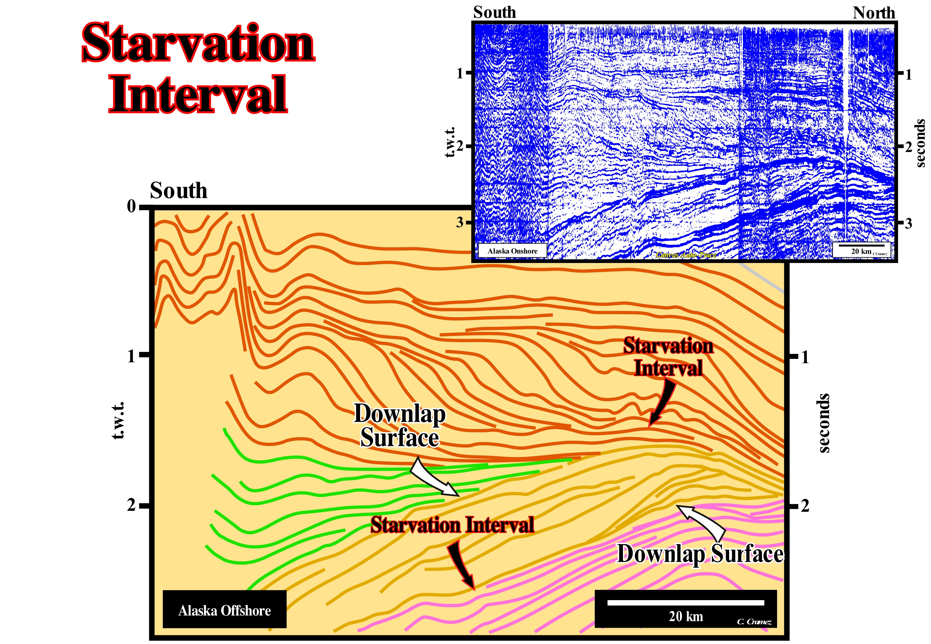
On this tentative geological interpretation of a Canvas auto-trace of an Alaska regional seismic line, two downlap surfaces, which dip in opposite directions, are very noticeable. They are defined by downlaps with opposite polarity (vergence) and characterize a condensed stratigraphic interval, whose condensation increases basinward. The downlap surface, along which the downlaps are oriented southward (condensation and hiatus increase) suggests an old continent to the north and an ocean to the south. On the contrary, the upper downlap surface and the progradations that define it have a northward polarity, which suggests an old continent to the South and an ocean to the North. It may be said that this tentative interpretation illustrates the collision between two continental divergent Atlantic-type margins (formed in a geological, globally, extensional context, that is, in association with the formation of new oceanic crust and outside of the Mesozoic/Cenozoic megasuture) or, in other words, a collision between two continents. In this particular case, the sea between the continental masses was the Cretaceous Interior Sea (Niobraran Sea or Inner Sea of North America). This sea was created when the Pacific and North American plates collided (Farallon plate subduction under the North American plate during the Cretaceous), creating the Rocky Mountains to the West. As during the Cretaceous, globally, absolute (eustatic) sea level (global sea level referenced to the Earth's centre) was high, waters of the north (Arctic Ocean) and the South (Gulf of Mexico) joined in the lowlands of the continent, forming a Niobraran sea that grew and decreased along the Cretaceous. This large inland sea that existed during the Middle Cretaceous and Terminal period, as well as, Early Paleogene, divided the North American continent into two land masses, Laramidia (West) and Appalachia (East). The first phase of the development of the Niobraran Sea began in the Middle Cretaceous, when the sea rose creating an arm of the Arctic Ocean that connected the West with North America, which created the Mowry Sea. In the south, the Gulf of Mexico, which was an extension of the Tethys Sea, merged with the Mowry Sea during the late Cretaceous to completely form the inland sea of North America (Niobraran). At its height, this sea stretched from the rocky mountains to the Appalachians (its width reached about 1,000 km for a length of 3,300 km) with a depth of 800-900 meters. At the end of the Cretaceous, the continuous survey of land has shrunk the sea which in the long run has completely withdrawn. This collision not only completely closed the ocean, which separated the divergent margins, but also produced a significant sedimentary shortening. The term collision used here has nothing to do with the transformation of kinetic or kinematic energy into deformation energy, as, for example, when a car strikes a wall. In the theory of plate tectonics, kinetic energy plays no role. Sediment deformation is not associated with any type of shortening. It is, above all, the loss of resistance to the deformation of the sediments in certain zones of the lithospheric plates that induces the deformation. In other words, sediment deformation under the action of tectonic forces affecting the entire lithospheric plate occurs when, locally, the sediments lose resistance to deformation either by a local increase in temperature or by a local increase in pressure. As suggested on this tentative interpretation, shortening seems more important in the overriding lithospheric plate (divergent margin located in the South) than in the descending (plunging) lithospheric plate. The identification and depth of the condensed intervals is very important in petroleum exploration, since they suggest the most likely location of the marine source-rocks. This tentative suggests that, in this region, there are, certainly, two levels of potential marine source-rocks, with different maturation of organic matter. The organic matter of the potential source-rocks of the lower level, probably, reach the oil window, which is, certainly, not the case for the organic matter of the potential source rocks associated with the base surface of the upper progradations.
Starved Basin..............................................................................................................................................................................Bassin sous-alimenté
Bacia subalimentada / Cuenca subalimentada / Unterernährte Sedimentbecken / 断源盆地 / Некомпенсированный бассейн / Bacino sotto-alimentato /
Sedimentary basin with a very low sedimentation rate. Such conditions are created by displacement, global, of the coastline (plus or minus the depositional coastal break) and the coastal deposits to the mainland (retrogradation) due to a relative sea level rise in acceleration (marine ingression greater than the previous one). Such displacement creates, in the distal part of the continental shelf, starved basin conditions, which favour the deposition and preservation of sediments rich in organic matter, which are, later, fossilized, in general, by progradations of the highstand prograding wedge.
See: « Downlap Surface »
Steady-State Theory......................................................................................................................Théorie de l'état stationnaire
Teoria do estado estacionário / Teoría de estado estacionario / Theorie der Steady - State / 稳态理论 / Теория стационарной вселенной / Teoria dello stato stazionario /
The Universe is expanding, but matter is created continuously in the space between galaxies, so the Universe has neither beginning nor end.
See: « Inflationary Universe »
&
« Big Bang (theory) »
&
« Nebular Theory »

Steady-State Theory was elaborated in 1948 by Fred Hoyle, Thomas Gold and Hermann Bondi as an alternative to the Big Bang model. It is a, widely, discredited model in Cosmology. He describes am expanding Universe in which new matter is created in the increasing intervals between galaxies, maintaining the density of matter in the Universe, and providing, constantly, protons for stars to produce their fusion processes in nucleosynthesis. The Universe would retain a density identical at all times, and would last for eternity what is an idea, philosophically "beautiful", as some cosmologists, physicists and other scientists say, but which has been refuted by astronomical evidence several times. The theory of chaotic inflation bears many similarities to the steady-state and quasi-stationary theory, but on a much larger scale than, originally, envisaged. It is the quasi-stationary Universe hypothesis that implies an infinite Universe, without beginning or end, in which inflation operates continuously on a scale beyond the observable Universe to create the matter of the cosmos. Both stationary and quasi-stationary states say that the events of creation of the Universe (new hydrogen atoms in the case of steady state) can be observed within the observable universe, while inflationary theories do not postulate inflation as an ongoing process within the scope of observable universe. Another alternative to the Big Bang hypothesis was presented in 1999, which can be considered as an eternal inflation, which is not the case with the theory of inflation initially proposed by Alain Guth. This theory postulates that the Universe, in its initial moment went through an exponential growth phase. This expansion can be modelled with a non-zero cosmological constant, which implies that the entire observable universe could have originated in a small region.
Stefan-Boltzmann Law.............................................................................................................................Loi de Stefan-Boltzmann
Lei de Stefan-Boltzmann / Ley de Stefan-Boltzmann / Stefan-Boltzmann-Gesetz / 斯特藩-玻尔兹曼定律 / Закон излучения Стефана - Больцмана / Legge di Stefan-Boltzmann /
The amount of energy radiated by a black body Z is proportional to the power four of the temperature: E = σT4, where σ is the Stefan-Boltzmann constant and T is the temperature (measured in degrees Kelvin). According to this law, any object having a temperature above absolute zero radiates energy.
See: « Absolute Zero »
&
« Sun »
&
« Aphotic Zone »
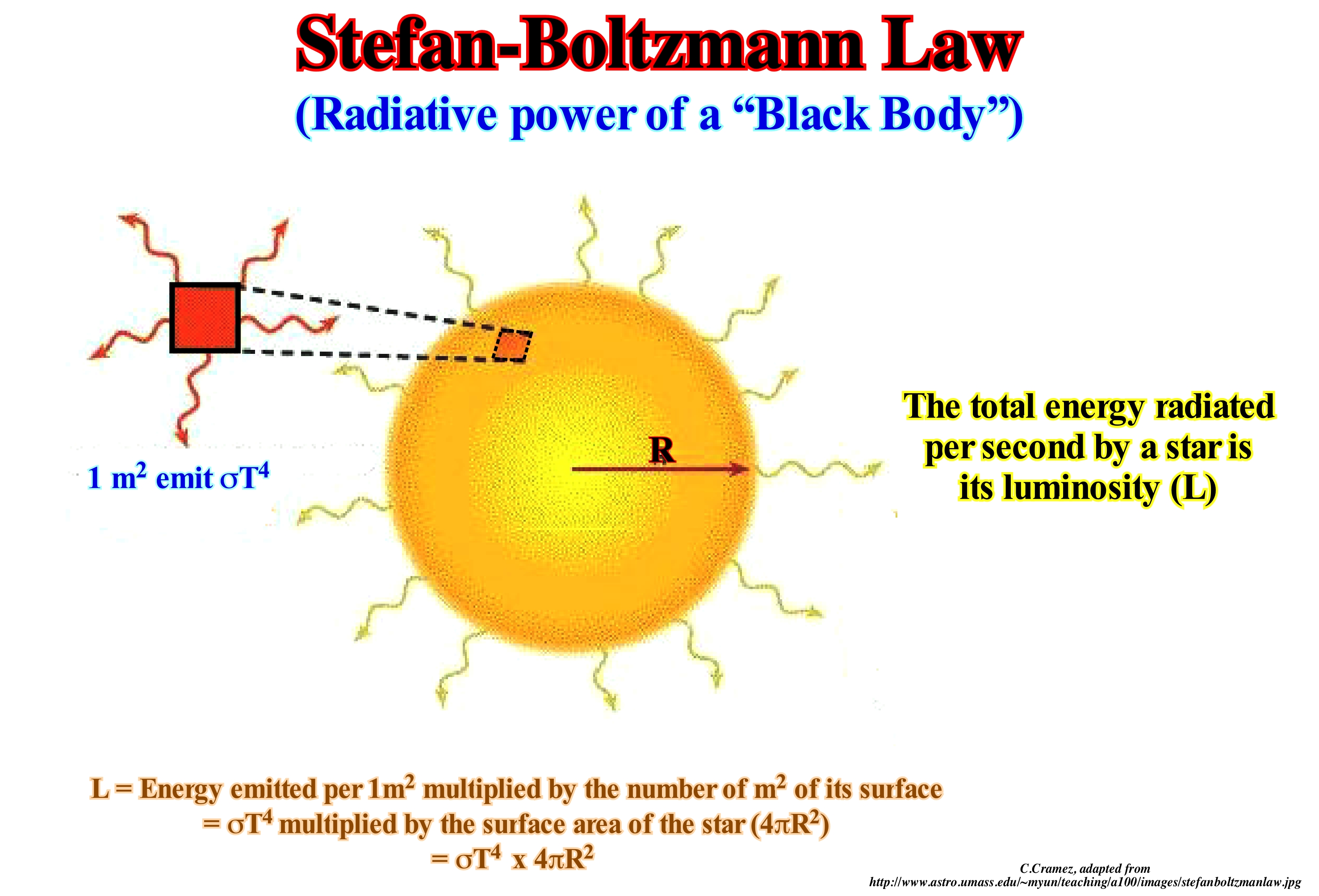
The total energy radiated by a black-body is proportional to the four power of body temperature. Do not forget that a black body is a hypothetical body that absorbs all the radiation that falls on it. This law has many practical applications, but an unprecedented application appeared for the first time in an unsigned article "Heaven Is Hotter Than Hell" in Applied Optics magazine, 11, 1972). The article begins with a quote from the Bible: Isaiah 30:26, "The light of the moon shall be as the light of the sun, and the light of the sun shall be seven times as the light of seven days." Moon, as much radiation, as we have received from the Sun and, moreover, seven times as much as the Earth receives from the Sun, that is to say, about 50 times more in all. The radiation received by Paradise will heat it to the point where the heat lost by the radiation is equal to the heat received. This means that Paradise loses 50 times more heat than Earth. According to Stefan-Boltzmann's law, the Earth's temperature is 525° C. According to religion Revelation 21: 8 "But for the fearful and unbelieving ... ... they shall have their part in the lake that burns with fire and sulfur, "which means that the temperature of Hell must be less than 445° C, which is the temperature at which the sulfur changes to gas. Subsequently Heaven or Paradise is warmer than Hell. In fact, with this law, Stefan determined the temperature of the surface of the Sun from the data of C. Soret (1854-1904), since the energy flux density of the Sun is 29 times greater than the density of the energy flow of a heated metal plate. Thus, it placed a round plate at such a distance from the measuring device that would be seen at the same angle as the Sun. Soret estimated that the plate temperature should be about 1,900-2,000° C, however Stefan assuming that ⅓ of the flux of energy of the Sun is absorbed by the Earth's atmosphere, corrected the flow of the Sun to a value 3/2 times greater, that is, 29 × 02/03 = 43.5.
Stellar Evolution..........................................................................................................................................................................Évolution stellaire
Evolução estelar / Evolución estelar / Stellar Evolution / 恆星演化 / Звёздная эволюция / Evoluzione stellare /
Process by which a star undergoes a series of radical changes throughout her life. As a function of mass, the lifetime of a star varies from a few million years to billions of years (109 years).
See: « Star »
&
« Sun »
&
« Nuclear Fusion »
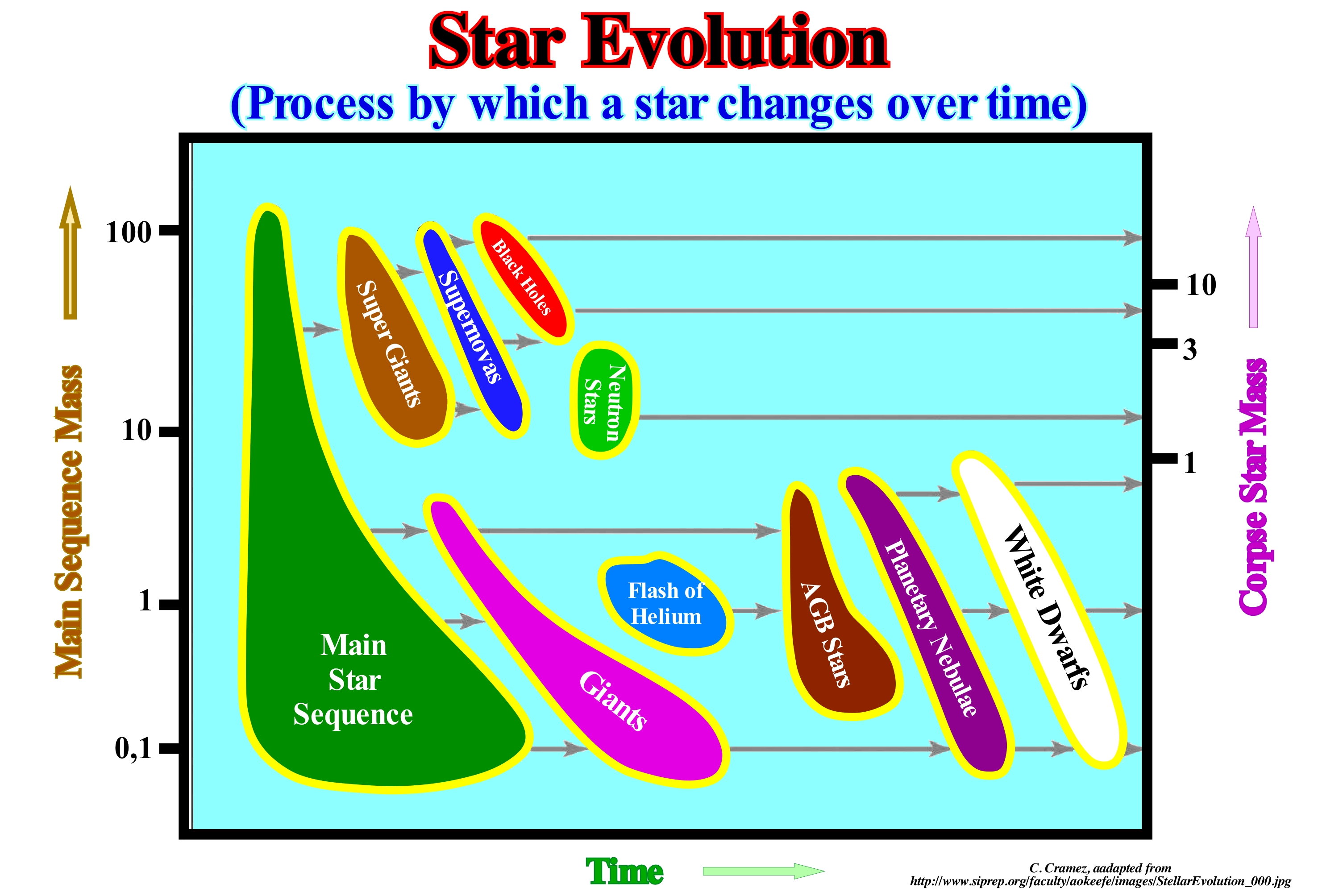
All stars form from clouds of gas and the condensation of dust from deep space. The chemical composition of this cloud and the amount of material it condenses determines what will happen to the star throughout its life. When a cloud of interstellar gas begins to condense under its own gravitation, any small rotation will be magnified, just as the speed of rotation of a skater increases as it closes the arms*. Little whirlwinds will form in this swirling cloud. It is these swirls that will eventually form stellar systems. All the gaseous material entering a given whirlpool releases an enormous amount of heat. The more the swirl is contracted, the warmer and opaque it gets, until the temperature is enough for it to begin to glow. Such an object is a proto-star**. When the proto-star is near full collapse under the action of its own weight, it will reach its maximum temperature. On the surface, it is warmer than when it becomes a star of the main sequence. But it is the temperature of its interior that determines the fate of the proto-star. In most cases, the total mass of the proto-star will be less than about 8% of the mass of the Sun, and the core temperature and pressure will not be sufficient for the thermonuclear reactions to begin, or if they are, the initial momentum of nuclear activity it will push the outer layers of the protostar out, abruptly extinguishing the fusion reactions. Such an aborted star is a brown dwarf (object of low luminosity that can not initiate the fusion of hydrogen) that is one of the objects more difficult to detect in a galaxy. In certain cases, the mass of the proto-star (and therefore its temperature) will be sufficient to ignite stable thermonuclear reactions. Immediately, the energy released from the new star nucleus reaches its surface and the newborn star enters a main sequence where it will spend most of its productive life. If the mass of a star is six times the mass of the Sun, it will expend its reserves of hydrogen after a few million years. A star more or less with the mass of the Sun will expend its reserves of hydrogen, more or less, end of 9 x 10⁹ years. A star with about 10% of the mass of the Sun will spend its reserves of hydrogen the end of 20 x 109 years. Either way since a star has burned all the hydrogen, its luminosity decreases and it can not offer more resistance to gravity. It contracts, its density increases as well as the temperature which can reach a hundred million degrees. At such a temperature the helium atoms produced by the combustion of hydrogen will group together three to three forming a new carbon atom 12 causing a large release of energy, since the mass of a carbon atom is less than the mass of three helium atoms. Such a rise in radiation balances gravity again, not only does the star stop contracting but increases its initial size several times. The radiation that escapes the surface is hundreds of times more important, but much more diluted. The surface of the star cools and its colour turns red to form a red giant, which as illustrated in this figure will continue to evolve into a white dwarf.
(*) The measure of the tendency of a body to keep rotating is called its angular momentum, and if there are no forces acting that tend to slow down or accelerate its rotation, then the angular momentum of a body will persist. It is particularly important that this rule applied to a system as a whole and that we did not have to know every detail about the system to be able to speak about the fate of its momentum (Hermann Bondi, 1964-Relativity and Common Sense. Dover Publications, Inc. New York).
(**) An object that will become a star if its mass is large enough.
Steno's Law...................................................................................................................................................................................................................................Loi de Steno
Lei de Steno / Ley de Steno / Steno-Gesetz / 速记的法律 / Закон наложения / Legge di Stenone /
The sedimentary beds settle in relation to the time, that is to say, the older ones in the inferior part and the more recent ones in the superior part. In the twenty-first century, it is very easy to say this law is trivial, but by the time Steno advanced it, of course, it was a brilliant daring. Sedimentary rocks are formed by particles, strata and beds that overlap one another, which means that in a continuous succession of sedimentary rocks, a certain layer is older than the overlying and younger than the underlying. This law is fundamental to the interpretation of Earth's history, since in no matter which location, it indicates the relative age of the layers and fossils that they contain.
See: « Stratification (sediments) »
&
« Geological Principle »
&
« Bed »
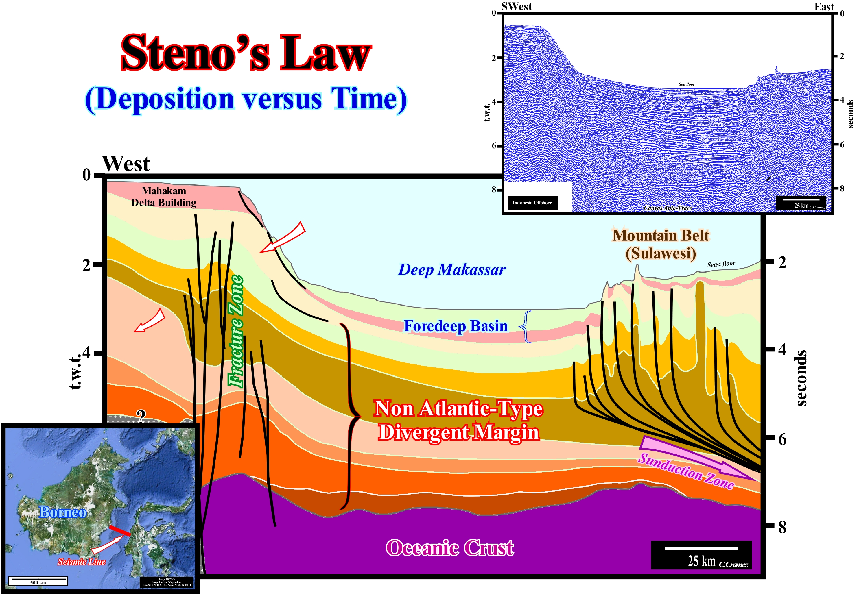
Steno's law implies that most sediments settle down, more or less, horizontally (Principle of original horizontality of Steno). Normally, when the sedimentary rocks are tilted, they are not in their original position. They were either elongated, by a tectonic regime in extension (formation of normal faults), or shortened, by a compressional tectonic regime (formation of folds and inverse faults). As illustrated in this tentative interpretation of a Canvas auto-trace of a regional seismic line across the Strait of Makassar (between the island of Borneo and the Celebes islands), it is clear that the law of original horizontality must be applied very carefully, even taking into account of the seismic pitfall introduced by the lateral variation of the water depth (the seismic waves travel more slowly in the water than in the sediments). Along all chronostratigraphic lines or along all deposition surfaces there are at least four slope breaks: (i) Bayline Break*, between alluvial and fluvial sediments ; (ii) Depositional Coastal Break, more or less, corresponding to the shoreline (mainly in the seismic line due to seismic resolution), which is located between the sediments of the coastal/deltaic plain and the prodelta ; (iii) Continental Edge Break (upper slope of the continental slope) between the sediments of the platform and the continental slope, which may or may not coincide with the basin edge(depending on whether the basin has a continental shelf or not and (iv) Basal Continental Slope Break between continental slope and abyssal. The clastic sediments of the prodelta and the continental slope do not settle horizontally, but with a certain inclination (generally between 1-3°) basinward. Presently, sequential stratigraphy tells us that within a sequence-paracycle sediments always have a progradational geometry, since during the stability period of relative sea level following a relative sea level rise (eustatic paracycle), the shoreline moves seaward. On this tentative interpretation, in the area of the Mahakam building delta, the eastward slopes of the sediments underlying the foreland basin are original, that is, they are contemporaneous with sedimentation. The sediments correspond to continental slope deposits. On the contrary, in the Sulawesi mountain belt, the dip of the sediments are posterior to the deposition. They result from the shortening, which continues today, as compressional structures affect the sea floor. Note that the Mahakam building delta is a stacking of deltas, whose thickness varies between 30 and 50 m. Do not confuse the continental slope bordering the continental edge with a prodelta. Seismically, at the level of sequence-cycle (prior to the melting of the Quaternary glacial caps and glaciers) the basin had no continental shelf and the shoreline coincided with the continental edge as far as the proceeds arrived. On the geological interpretation of seismic lines, in addition to Steno's law, other law or geological principles must always be used: (a) The Goguel's law, which says during deformation, the volume of sediment remains, more or less, constant (this law is approximate since it accounts for the volume reduction induced by the decrease in porosity in depth and by the dissolution phenomena which can in some cases reach about 30% of the total volume ; ( b) the J. Walther's law, that says that in continuity of sedimentation, a lateral succession of depositional systems is also vertically, that is to say, if laterally, seaward, is the sequence a, b, c, vertically, and from the bottom up, there will be c, b, a ; (c) Original Horizontality Principle, which says that the sedimentary layers are deposited horizontally ; (d) Original Continuity Lateral Principle, according which sedimentary layers deposited in lateral continuity pinchout or terminate by downlapping or onlapping against the edges of the original deposition sectors ; (e) Intrusion Principle, which says that the relative age between two igneous rocks, or between an igneous rock and a sedimentary rock, can be deduced by the geometrical relations between them: "An intrusive igneous rock is younger than it penetrates" ; (f) Ochkam principle, which says that plurality should not be invoked without necessity ("Pluritas non est ponenda sine necessitate"), etc., etc.
(*) Posamentier and Vail (1988) defined the bayline in a, more or less, following way: (a) The coastal plain is formed by processes of sea bottom progradation, rather than by exhumation ; (b) The sediments that accumulate on the coastal plain during the progradation of the shoreline form part of what is called the coastal wedge (coastal prism), which includes fluvial and shallow water deposits ; (c) The coastal prism has the wedge shape and extends continentward by onlapping over the pre-existing topography ; (d) The upstream boundary of the coastal wedge is the bayline, which may move upstream when the shoreline progradation is accompanied by aggradation. Thus, the bayline is the boundary between the coastal plain and the alluvial plain and upstream of the bayline, relative sea level changes have, practically, no influence on depositional systems.
Steric Sea Level Change................................................................Changement de niveau de la mer stérique
Variação estérica do nível do mar / Cambio Estérico del Nivel del Mar / Steric Sea Level Veränderung / 空间变化 / Стерильное изменение уровня моря / Cambio Steric del nivello del mare /
Thermal expansion of the oceans (if the temperature of the oceans increases, the density of the water decreases and, for a constant mass, the volume increases) or steric sea level rise, which may be an important factor of absolute sea level change.
See: « Eustatic Megacycle »
Stochastic Theory (Meanders)..........................................................................................................................Théorie stochastique
Teoria estocástica / Teoría estocástica (meandros) / Stochastische Theorie / 随机理论 / Стохастический теория / La teoria stocastica /
The evolution of a meander seems to be the result of stochastic fluctuations (which are subject to the laws of chance) of the direction of flow due to the presence of obstacles that change the direction of the current path.
See: « Meander Belt »
&
« Oxbow (channel) »
&
« Point Bar »
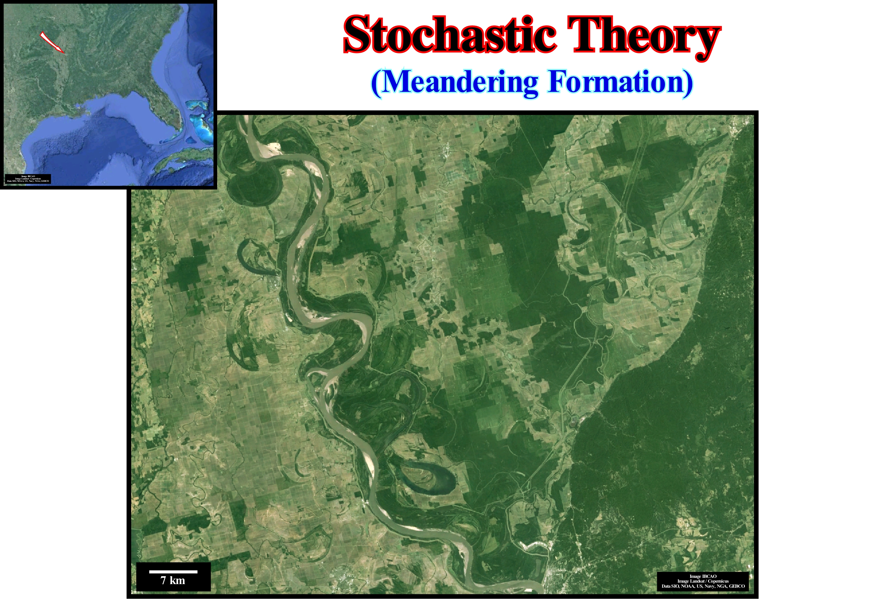
A meander is a sharp curve of a river that runs in its alluvial plain and that changes shape and position with variations of greater or lesser energy and fluvial load during the seasons. The meanders are frequent in alluvial plains, but occur more narrowly, in other conditions as on horizontal sedimentary terrain (valley meanders). The channel of the river, constantly,, changes position along the alluvial plain, through a, more or less, continuous process of erosion and deposition along its banks, which is why the meander is often called a wandering meander. The outer margin of a meander (the centrifugal margin of the stream) presents ravines that are, progressively, eroded. In the inner margin deposition, mainly, of sand occurs. This process accentuates the curvature of the meander that forms, eventually, an entire loop creating a truncation at a point where the fluvial stream begins to flow, leaving the old meander abandoned and closed with a U-shaped lake. Three theories have been advanced to explain the formation of meanders: (i) Stochastic Theory ; (ii) Equilibrium Theory and (iii) Geomorphological or Morphothectonic Theory. According to stochastic theory, as its name suggests, a meander is interpreted as the result of occasional fluctuations, in the direction and direction of the runoff, due to the presence of obstacles in the riverbed. This theory is based on the fact that given an artificial, flat and sloping surface, rains run on slides, but even then, the adhesion of the water to the surface and the cohesion of the droplets produce fillets in a random manner. The natural surfaces are rough and eroded. The result of all physical factors, which act at random, are non-rectilinear channels, which become, progressively, sinuous. In equilibrium theory, the meanders decrease until the current gradient strikes a balance between soil erosion and current carrying capacity (both water and deposits). A descending mass of water must renounce the potential energy it had, since it has the same velocity at the end as at the beginning. It is eliminated by interaction with the bedding material. The shortest distance, that is, a straight-line channel, gives the highest energy results per unit length, which further changes the channels, creating more sediment and the liking of the stream (silting). The presence of meanders along the course allows adjusting the length to achieve an energy balance per unit length at which the current carries all the sediment it produces. Finally, in Morphotectonic theory, the tectonic structures of the terrain, especially the folds and faults, are the main responsible for the formation of the meanders. The percentage of meanders or sinuosity index of a watercourse is a way of quantifying the amount of intricacies of a river or any other watercourse (https://en.wikipedia.org/wiki/Meander). This index is calculated by dividing the length of the water course by the length of the valley. A perfectly rectilinear river has a sinuosity index of 1, which means that the length of the river is equal to the length of its valley. The higher the index (> 1) the more sinuosity or meanders the river has. The sinuosity index is calculated from a map or aerial photograph, measuring the distance between two points below (reach), which must be at least 20 times the average channel width. The length of the current is given by the thalweg, the length plus the range (length of the valley below), while the lowest value of the ratio is the length is below (air distance between the two points that determine the range). The sinuosity index plays a role in the mathematical descriptions of watercourses. The sinuosity index can be precise, since the valley (not the river) does not always have meanders; for example, the length of the valley below is not identical to the range. In this case, the valley index is the valley meander ratio, while the channel index is the meander channel ratio. The sinuosity index of the channel is the length of the channel divided by the length of the valley and the standard sinuosity index is the index of the channel divided by the index vale. Distinctions can become even more subtle. The sinuosity index also has a non-mathematical utility. Water-courses can be classified into categories according to these indices; for example, when the index is between 1 and 1.5 river is winding, but if the index is 1.5 and 4 the river has meanders. The index is a measure of water velocity and sediment load, which will be maximum when the index is 1 (rectilinear water-course).
Storm Delta (Wave delta)................................................................................................................................................................Delta de tempête
Delta de tempestade / Delta de tempestad / Sturmdelta / 风暴三角洲 / Дельта, образованная волнами при шторме / Delta di tempesta /
Delta of relatively small dimensions formed in the inner part (upstream) of the openings of lagoons, bars or barriers, due to the accumulation of materials transported by the storm waves. Synonym with Wave Delta.
See: « Delta »
&
« Wave Delta »
&
« Major Storm Wave Base »
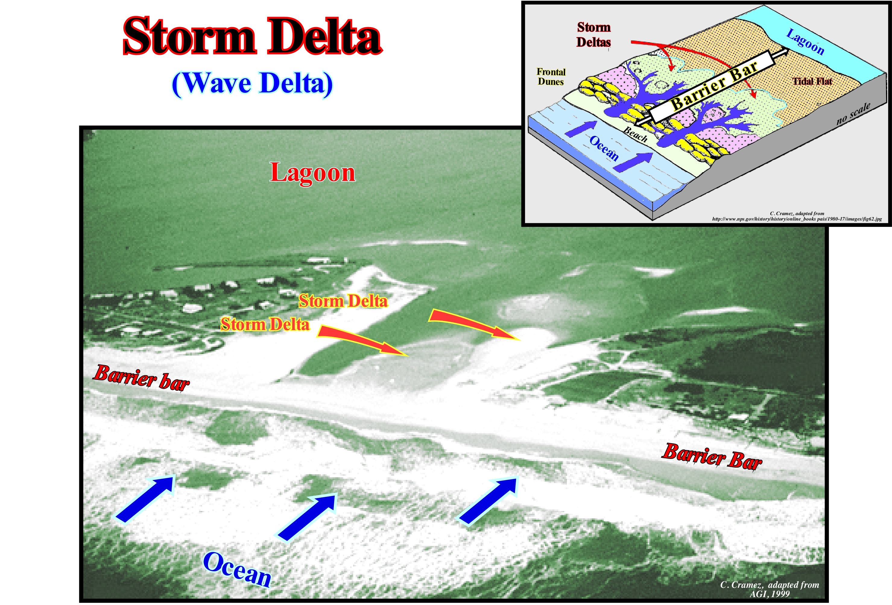
This photograph, which corroborates, perfectly, the geological model illustrated in the diagram, shows two small storm deltas, which, as its name suggests, were formed during a storm or during the equinoctial tides. Certain geoscientists also call this type of delta, wave delta. In the geological model of a storm delta, it recognizes: (i) The ocean with waves parallel to the shoreline ; (ii) A barrier-bar with the beach and frontal dunes ; (iii) The openings or passages (inlets) on the barrier-bar ; (iv) The intertidal plain (tidal flat), in which the storm deltas are deposited and (v) The lagoon. In the photograph it is well seen sea-waves waves propagate, perpendicularly, to the barrier-bar (or barrier island), which marks the outer limit of a lagoon. In these conditions, i.e., when the wave direction (crests line) is, more or less, parallel to the shoreline, it is unlikely that a significant beach drifting* (foreshore drift) current exists in this area. On the inner side of the barrier-bar, where there was, probably an old inlet (an entrance to the lagoon), there are at least two recent storm deltas formed by overflowing of the waves during a period in which the height of the waves was very great, as during storms, cyclones or tsunamis. It is very likely that the area where dwellings were built (left sector of the photograph) would also correspond to an old storm delta. The evolution and sedimentological characteristics of the overflow deposits associated with the cyclone Ivan (Florida, 2004) can be applied in general to all storm deltas. Thus: (i) The first response to an overflow of the sea waves on a barrier-bar is an important erosion of the longshore, beach and dunes ; (ii) The eroded sediments are transported and redistributed, mainly, on the inner side of the barrier-bar ; (iii) At the beach, deposits are limited by a basal erosion surface and seaward slope ; (iv) In the inner part of the barrier bar, the presence of vegetation beneath the overflow deposits suggests little or no erosion before deposition behind the frontal dune ; (v) At the lagoon platform (area near the shoreline), the deposits have a horizontal or sub-horizontal stratification ; (vi) As the water-depth increases, the deposits are thicker and characterized by sigmoid progradation towards the deepest part of the lagoon. According to Galloway, taking into account the dominant forces in the formation process, he classified the deltas into three main types: (i) Deltas dominated by the terrigeneous influx of the rivers; (ii) Deltas dominated by sea-waves and (iii) Deltas dominated by tidal activity and tidal currents. The river-dominated deltas are cut and have many distributaries with marshes, bays or tidal flats in the inter-distributary regions. They occur when the river current and sediment transport are strong and other effects, such as rework by waves or tides, are smaller. These deltas tend to form large deltaic lobes in the sea, which may have little more than the distributary channel, and have a natural marginal dikes (levees) exposed above sea level. Due to their resemblance to a bird's paws, they are often referred to in the geological literature as a "bird's foot deltas", as is the case of the deltas of Mississippi Building Delta. When much of the floodplain between the distributary channels is exposed above sea level, the delta displays a lobate form. Wave-dominated deltas are more regular, exhibiting curved and arched shapes with frequent beach ridges, such as in the Nile or Niger delta buildings, where the surf of the waves causes a mixture of fresh and salt water. The flow lose, immediately, its energy depositing all its load along the coast. Tidal-dominated deltas occur in areas with high tides or high speeds of tidal currents. Such deltas often resemble an estuarine bay filled with many elongated islands parallel to the main tidal stream and perpendicular to the shoreline, such as in the Brahmaputra and Mahakam delta buildings. The deltas of the Mississippi and Yukon delta building are, typically, dominated by the terrigeneous influx carried by the water-courses. The deltas of Senegal and the San Francisco delta buildings are dominated mainly by sea wave activities, while those of the Fly delta building are dominated by tides and tidal currents.
(*) Longitudinal current form in the beaches, outside the surfing area, reaching the swash currents, as a consequence of the water and sediments the uprush and backwash currents, when the surfing is obliqued to the coast.
Storm & Tsunami.....................................................................................................................................Dépôt de tempête et tsunami
Depósito de tempestade e tsunami / Depósito de tempestad y tsunamis / Sturm Anzahlung & Tsunamis / 风暴沉积与海啸 / Отложения, образовавшиеся в результате шторма или цунами / Deposito di tempesta e tsunami /
Sediment, often, sandy deposited upstream of the beach by tsunamis and large storms, particularly, by hurricanes, as they flood the coastal regions. A proper identification of the geological records of layers deposited by a tsunami or of a storm deposit is essential to assess the frequency of these events and thus predict the risk they can produce.
See: « Storm Delta »
&
« Swell »
&
« Major Storm Wave Base »
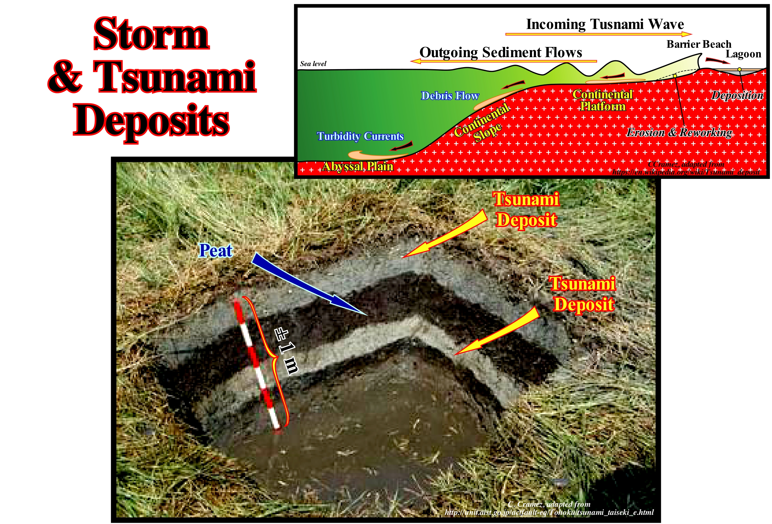
Storms and tsunamis occur in the oceans, either on a geological scale (measured in thousands, millions or even billions of years), or on a historical or human scale, that is, on the scale of tens, hundreds, even thousands of years. The storms, which are atmospheric phenomena marked by strong winds and rains, thunderstorms, lightning, etc., are associated with particular meteorological conditions and the cumulonimbus (type of cloud characterized by a great vertical development, that form from the development of clusters which, by the action of rising winds, gain mass and volume and become cumulus congestus and, at the peak of its evolution, becomes a cumulus-nimbus, when they reach more than fifteen kilometers of height). Storm clouds* form when there is sufficient heat release due to the condensation of cloud droplets and ice crystals (in the cold part of the clouds). Storms may appear isolated, or in groups in the form of convective clusters, more or less disorganized, or in the form of storm lines, called instability lines, or when one of the storms in the cluster grows more than all others and reaches large proportions (typically 10 km x 10 km x 12 km in medium latitudes) as a super-cell. Within the storm clouds there are vertical ascending and descending vertical movements, which generates much turbulence (mixing and introducing air from the top as they grow). The air entering through the top of the clouds is very dry and evaporates the drops and crystals of the clouds generating a cooling of the air and its descent through the cloud, in the form of descending currents, while rising currents rise due to the heating of the clouds. portions of air by the release of latent heat of condensation. Storms occur when the atmosphere is thermodynamically unstable, with potential energy available to be converted into upward air movement within the clouds and descending outside them and when there is convergence of the wind on the surface, such as near a front of sea breeze during the convective period (https://pt.wikipedia.org/wiki/Tempestade). A tsunami is a series of large waves that propagate through an aquatic environment (ocean, sea or lake), resulting from the sudden movement of large amounts of water, usually, caused by an earthquake, submarine landslide, meteorite impact, volcanic explosion, etc., that can become, when reaching the coast, in huge waves of surf with a great destructive power. Certain tsunamis result from the displacement of two faulted blocks under the sea. Recently, in onshore, geoscientists have begun to study the deposits induced by storms and tsunamis and to use them to identify areas where they are. highly. probable. These studies gave surprising results. However, several questions remain unanswered, for instance: How can tsunami deposits be distinguished from deposits associated with major storms? Tsunami deposits have enormous potential to record the flow velocity and depth. In Libidos Lagoon, Portugal, the earthquake of November 1, 1755, which in reality corresponded to three earthquakes (9:40 am., 10 am. and 12 am. in the morning), generated a tsunami of about 15-20 m of height with a penetration of about 2.5 km (Sousa Moreira, 1993). Four stratigraphic intervals were deposited in association with the tsunami: (i) Coarse clay ; (ii) Green sand ; (iii) Fine Shales and (iv) Fine Shales with Sand Intercalations. According to certain geoscientists it seems that the earthquake of November 1, 1755, was the fourth major earthquake that occurred in the Lisbon area (Portugal). Significant earthquakes seem to have occurred before 1755: (a) In 1009 ; (b) In 1344 and (c) In 1535. In this photograph are illustrated two tsunami deposits separated by a peat deposit (dark grey) on the Para Thong island located of 125 km north of the island of Ketchup, Thailand. These deposits appear to have been induced by an earthquake that occurred in 1881 along Soda’s ocean trench, which produced a tsunami less than 1 m (according to a tidal control station in India). The 2004 tsunami also flowed about 2 km over the Para Thong plain (covering the intermediate peaks and depressions with a sand horizon of thickness ranging from 5-20 cm. According to some geoscientists, in the same area, in addition to the 2004 and 1881 tsunamis, other significant tsunamis occur around the 12th century (550-700 years ago).
(*) The shape of clouds depends on the importance of horizontal flow. The altitude of the base depends on the level of condensation. The thickness depends on the amplitude of the vertical movement as well as the stability/instability of the raised air. The clouds with a high base do not produce much rain, as well as, the low clouds of weak thickness. The button-shaped clouds (cumulus-nimbus and cirrus) are the responsible for most of the precipitations, which are more intense when the thickness is important and the top is higher.
Strand............................................................................................................................................................................................................................................Estran (Replat)
Espraiado (estrão, faixa entremarés) / Strand / 斯特兰德 / Полоса берега, перекрываемая водой во время прилива / Zona inter-cotidale /
Coastal space between the levels of the highest tide and the lowest tide. Strand is also called a range or intertidal zone or intertidal zone.
See: « Tide »
&
« Relative Sea Level Change »
&
« Spring Tide »
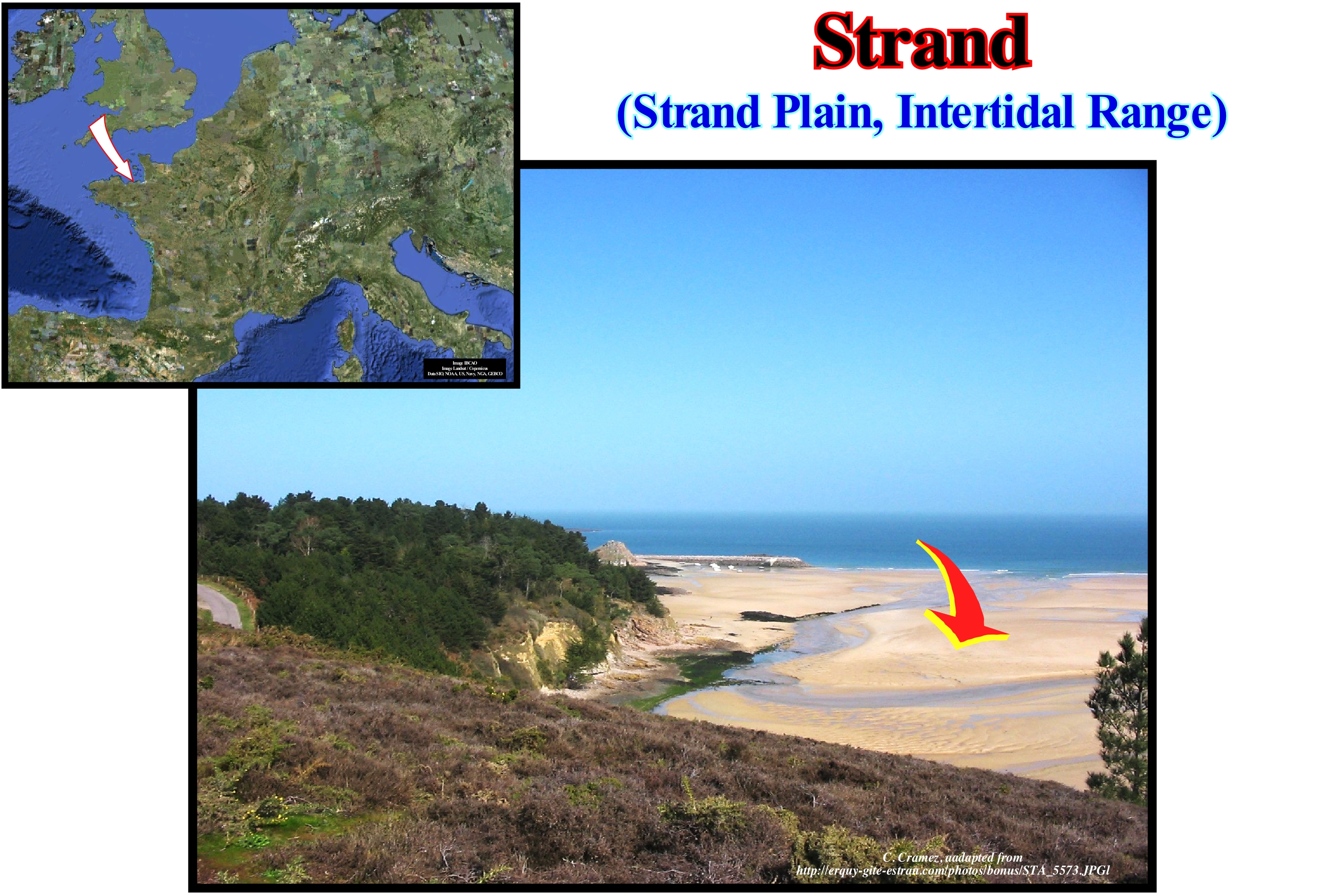
Function of tidal range and slope of the coast, the strand or intertidal zone, for certain geoscientists, may be, more or less, large. Within a sequence-cycle when the continental encroachment invasion (horizontal component of coastal aggradation) is large, probably the strand is also very large, since the continent's morphology is very flat. As an extreme case, we can mention Guinea-Bissau, where the strand represents about 20% of the area of the country. Strand, also known as the coastal zone, in marine aquatic environments is the area at the edge of the sea, in which the sea floor is exposed during low-tide and submerged at high-tide, i.e., the area between tides. In the strand, the most common organisms are small and many are, relatively, simple organisms. This is due to a number of reasons: (i) The supply of water that marine organisms need to survive is intermittent ; (ii) The action of waves on the coast can dislodge poorly adapted organisms ; (iii) High sun exposure and temperature variations can be extreme, from very hot to near zero in cold climates (cold seas) and (iv) Salinity is very strong, as salt water stagnates in puddles evaporate originating salt deposits. These four factors make the strand an environment not very suitable for life. A typical rocky coast can be divided into a sea-spray zone (also known as the supra-tidal zone), which is above the tidal line that occurs during the syzygies and which is covered by water only during storms, and an intertidal zone, which lies between high and low-tides. Throughout most coasts, the intertidal zone can be easily subdivided into the following sub-zones: (a) High-tide zone; b) Area of average tide and c) Area of low-tide. The tide zone is submerged and flooded for approximately equal periods of time in each tide-cycle. Consequently, temperatures are less extreme due to less direct exposure to the sun and therefore the salinity is only slightly higher than the ocean.
(*) The sea-spray is the foam cloud formed by droplets of sea-water and bubbles enclosing saline micro-crystals resulting from the surfacing foam that is projected against the shore and transported inland by the wind.
Strata................................................................................................................................................................................................................................................................Strates
Estratos / Estratos / Strata / 阶层 / Слои / Strata /
Set of layers, i.e., set of sedimentary intervals that are deposited one at a time with the oldest deposited in the base.
See: « Stratification (sediments) »
&
« Turbidite »
&
« Steno's Laws »
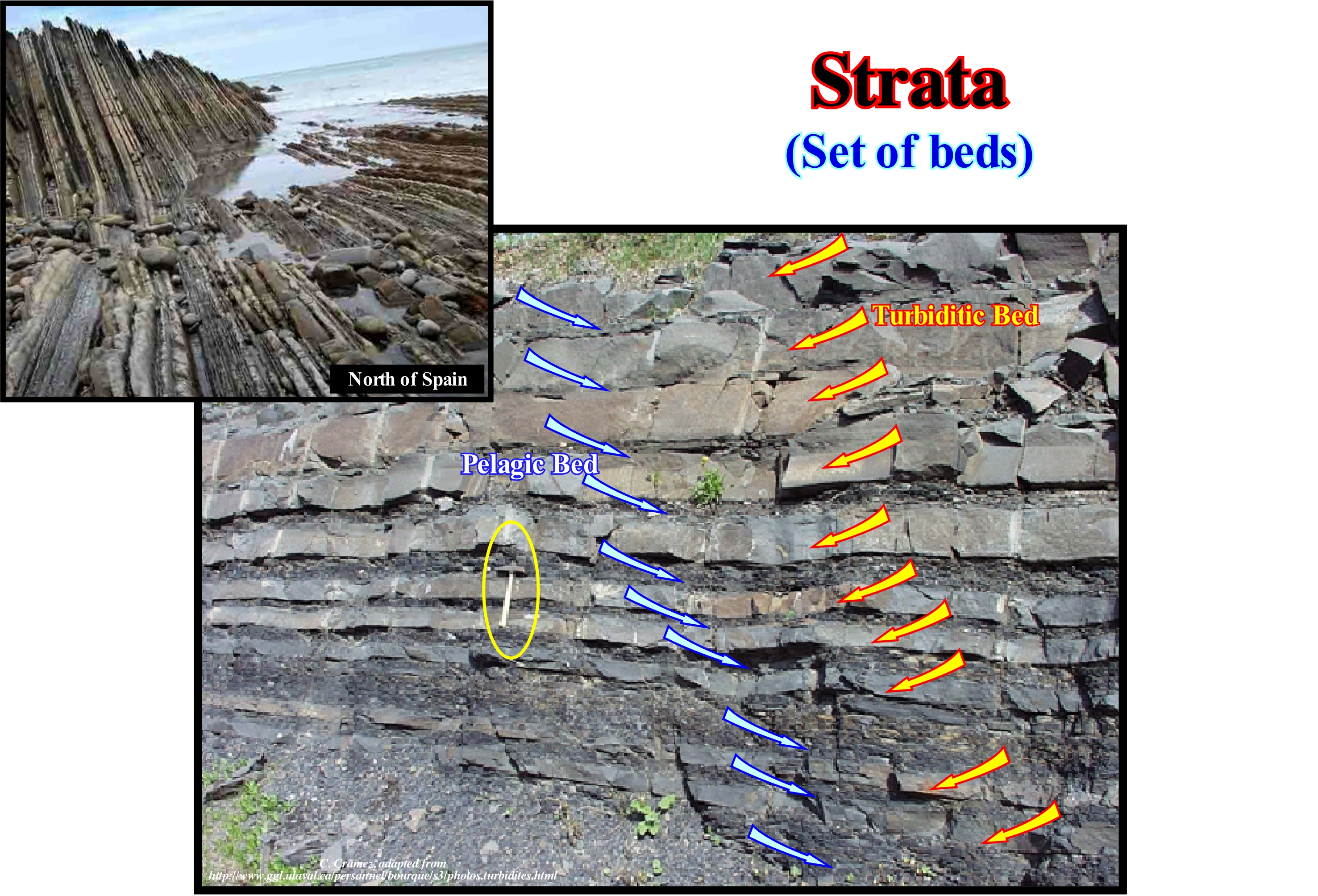
The beds of the sedimentary rocks are, in most cases, arranged in packets of similar strata superimposed between them. These bundles or packages are, more or less, distinguished by the lithology (limestone, sand, clay, etc.) and by the organization of strata (beds, more or less thin, alternating with others of different lithology) from the underlying packages (previous) or overlying packages (more recent). Such a set of layers of decametric thickness is called a set of beds (or strata), which are nothing else, than portions of packages of greater thickness (hectometre), which are called formations. The geological formations themselves oppose (by the nature of the rock and organization in strata) the neighbouring formations of the sedimentary column. The name of the formations, which is given to the successive bundles of strata, comes from the change of appearance of the layers, which differentiate them which is linked to a modification of the sedimentary deposition process. These changes are due to changes in the nature of the deposited rock ("facies *"), or in strata (stratonomy) or both (these groups of characters also serve as the basis for the definition of the different categories of formations). The stacking of the sedimentary layers of a region usually involves the stacking of several formations, which differ from one another by these two types of characteristics ("facies" and "Stratonomy"). The formations are often identifiable in the landscape due to the different influence they have on the relief and vegetation. Each formation has a name that is usually taken from the locale where it is well represented. In this photograph, each bed (stratum) represents a turbidite deposit, that is to say, the deposit of a turbiditic current The turbidites are formed of sand. The shaly beds between each of the sandy beds represent the fine material (shaly), which was deposited by decantation between each turbidite bed. A turbidite is deposited instantaneously, that is, in some hours, while shaly deposits represent deposition times of hundreds or thousands of years.
(*) Term used by Gressly, in 1838, to express a lithology and associated fauna. This term has lost much of its original meaning. Frequently, certain geoscientists, particularly American geoscientists use the term facies to express the shape, appearance, and deposit conditions, that is, more or less synonymous with the sedimentary environment. They say, for example, "a sand interval of deltaic", while a European geoscientist says "an interval of sandy facies from a deltaic environment."
Stratal Discontinuity...................................................................................................................Discontinuité dans les strates
Descontinuidade nos estratos / Discontinuidad de estratos / Diskontinuität der Schichten / 间断地层 / Разрыв слоев / Discontinuità degli strati /
Stratigraphic surface created by erosion or by a period of time without deposit.
See: « Concordance »
&
« Unconformity »
&
« Disconformity »
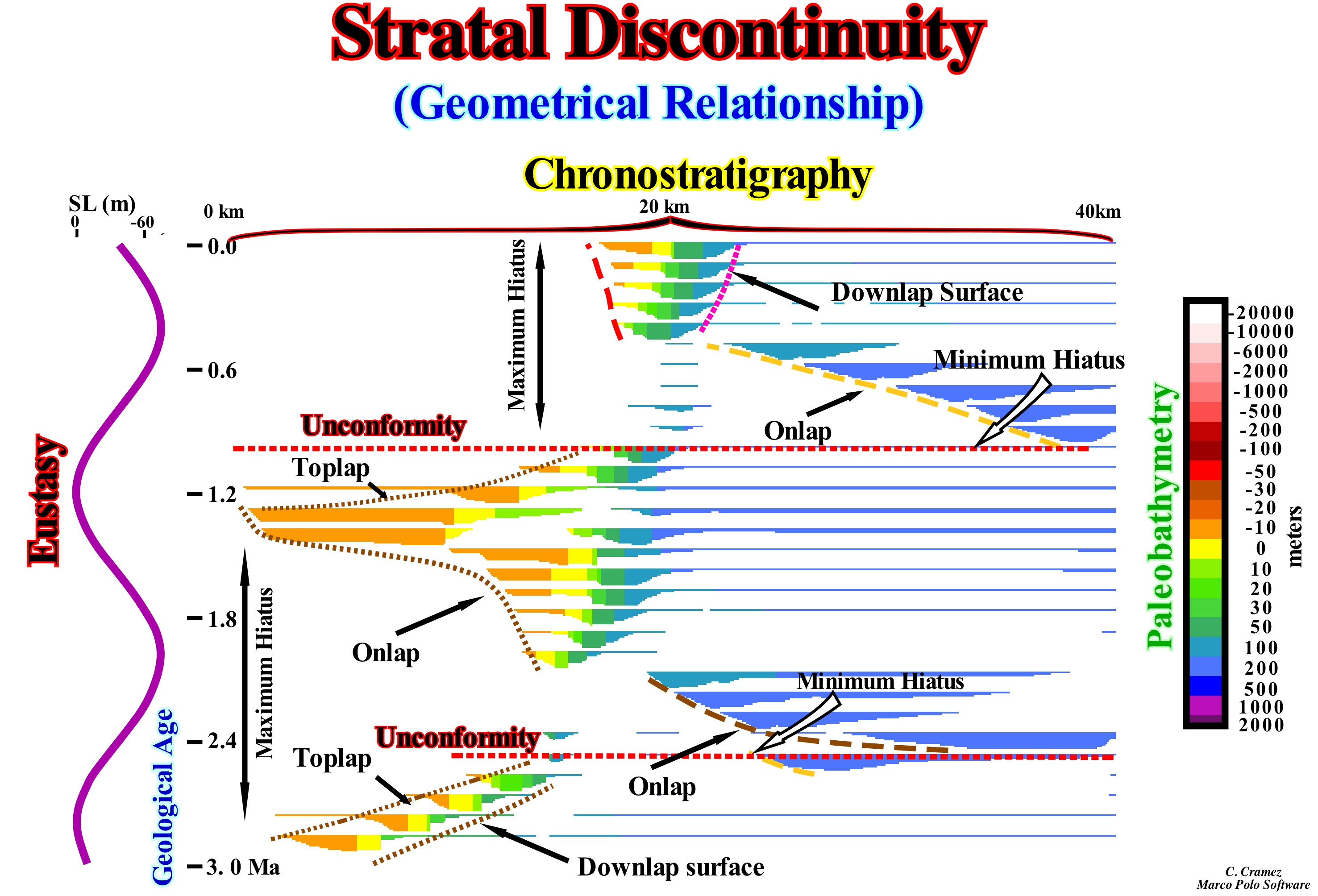
The discontinuities in the strata may be: (i) Unconformities, erosional surfaces induced by significant falls of the relative sea level*. which limit the stratigraphic cycles and, in particular, the sequence-cycles ; (ii) Disconformities** and (iii) Hiatuses by non-deposition (time intervals related to a sedimentation discontinuity due to non-deposition and/or erosion of already deposited layers). All these surfaces, when represented in a chronostratigraphic diagram, are generally composed of two subhorizontal segments separated by a slope. The age of the unconformities is given by the age of the minimum hiatus, which, in the great majority of cases, is located at the base of the slope or abyssal plain, where there is, practically, a continuity of sedimentation. The limit of a stratigraphic cycle, such as the lower boundary of a sequence-cycle, corresponds to an erosional surface (unconformity), which represents an old hiatus created by erosion (at least upstream of the basin edge). Within a sequence-cycle, a more recent hiatus than the one associated with the lower unconformity, which limits it, is generally a hiatus by no deposition. In this chronostratigraphic diagram are represented: (i) Eustasy (variations of the absolute or eustatic sea level) ; (ii) The Terminations of Reflections (lapouts) ; (iii) Stratal discontinuities, i.e., onlaps, downlaps and toplaps ; (iv) Hiatuses ; (v) Unconformities and (vi) Paleobathymetry (bathymetry of the marine environment in which the sedimentation of a particular lithological unit occurred, which characterizes the time of geological history in which it took place). The main downlap surfaces (which within the sequence cycles limit the transgressive intervals, TI, from the highstand prograding wedge, for instance) and the onlap surfaces are, easily, identified, since the first incline continentward, in this case to the left, but prograde to the right, that is, seaward. Onlap surfaces, which fossilize the unconformities, dip to the right (seaward), but encroach the continent (left). The toplaps are recognized under the unconformities, but move to the right (seaward), unlike the onlaps. The maximum and minimum hiatus are, easily, recognized, which allows a, more or less, correct dating of the unconformities (minimum gap). Paleobathymetry increases seaward (right). The onlap surfaces, in deep water, suggest submarine basin floor an slope fans. The only way to date, more or less, correctly an unconformity is to date the submarine basin floor fans associated with the relative sea level fall that caused the erosional surface (unconformity), which means that in all In other cases, the dating error is very large. A good dating of a submarine basin floor fans (SBFF) requires a well core containing the pelagic layer, which usually covers each turbidite layer, since it is the only one that can contain the fossils not only representative of the sedimentary environment, but age of deposition as well.
(*) Local sea level, referenced to any point on the Earth's surface that may be the base of the sediments or the sea floor and that is the result of the combination action of the absolute or eustatic sea level, which is the sea level referenced to the Earth's centre, and tectonics (subsidence, when the predominant tectonic regime is in extension or uplift, when the tectonic regime is in compression).
(*) For many geoscientists, a discontinuity denotes a transition or contact between intervals with different densities, such as the Mohorovičić discontinuity, or with different sedimentary facies, or between intervals separated by a hiatus (absence of significant deposition). In geology there are several types of discontinuities: 1- Stratigraphic ; 2- Sedimentary ; 3-Lithological ; 4 - Tectonics, etc. Within the lithological discontinuities, which are the most important in sequential stratigraphy, we can recognize: (i) Concordant discontinuities, when there is continuity between successive intervals ; (ii) Paraconform Discontinuities or Paraconformities, when there is no difference in attitude between overlapping intervals, but there is a hiatus due to the absence of significant deposition between them ; (iii) Non-Conform Discontinuities or Non-Conformities (which certain authors call Heterolithic Disconformities), when there is a contact between a sedimentary interval and an older igneous body ; (iv) Discontinuous Discontinuities or Disconformities, when the layers of the intervals are parallel on one side and the other side of the contact surface which does not conform to the regional stratification ; (v) Discordant Discontinuities or Unconformities, when the two intervals are separated by an erosional surface induced by a relative sea level fall ; (vi) Enhanced Discordant Discontinuities or Tectonic Enhanced Unconformities, when the sediments of the interval overlapping an unconformity were deformed by tectonics (shortened or lengthened) ; (vii) Intrusive Discontinuities, when an igneous body traverses a sedimentary series ; (viii) Mechanical Discontinuities, when they are induced by faults, etc. (https://estpal13.wordpress.com/ 2013/06/04 / discontinuities-sedimentary-and-stratigraphic /)
Stratal Patterns...........................................................................................................................................................................Configuration des strates
Configuração dos estratos / Configuración de los estratos / Konfiguration der Schichten / 地层的配置 / Схема пластов / Configurazione di strati /
Geometry of the strata within a given stratigraphic unit. The configuration translates deposition processes and late tectonic deformations. It is important to distinguish the sedimentary geometry (internal configuration) from the strata termination. The first allows to interpret the geological environments, the second allows to define the unconformities.
See: « Strata »
&
« Seismostratigraphy »
&
« Sedimentary Environment »
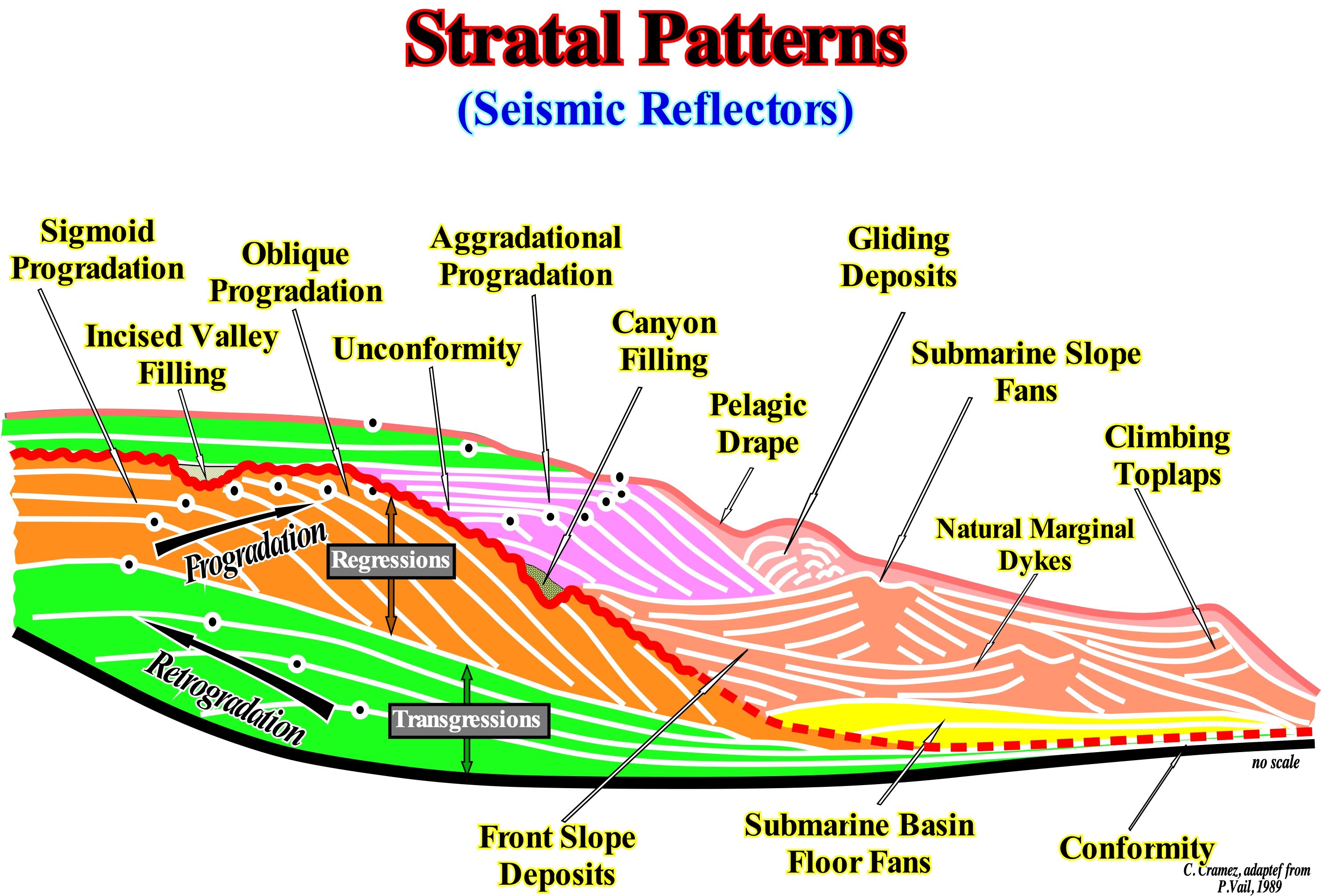
Most of the geometric configurations of the strata (or chronostratigraphic reflections) are illustrated in this sketch, in which two stratigraphic cycles called sequence-cycles (incomplete) are represented. The lower sequence-cycle is composed by the subgroups that form the highstand systems tracts group, that is, the transgressive interval (TI), coloured in green, and the highstand prograding wedge (HPW), coloured in orange. The transgressive interval (TI) which has, a retrogradational, globally, geometry is separated from the highstand prograding wedge (HPW), whose geometry is progradational, by a downlap surface. Along this surface, the hiatus due to non deposition increases seaward. These subgroups of sedimentary systems tracts are formed for sequence-paracycles induced by marine ingression (rises of the relative sea level, which is local and referenced either to the seafloor or to the base of the sediments, which is the result of the combined action of the absolute sea level or eustatic sea level, which is supposed to be global and referred to the Earth's centre and tectonics) without a relative sea level fall between them. No sedimentation occurs during marine ingression or eustatic paracycles as they are, sometime, termed, somewhat abusively, in sequential stratigraphy. The upper sequence-cycle, which is also incomplete, consists mainly of the the lowstand systems tracts subgroup of low-level sedimentary courts : (i) Submarine basin floor fans (SBFF), interval, coloured in yellow ; (ii) Submarine slope fans (SSF), light brown coloured interval and (iii) Lowstand prograding wedge (LPW), coloured in violet. A narrow transgressive interval (TI) culminates the upper sequence-cycle. The lower sequence-cycle shows, clearly, that the transgressive interval (TI) corresponds to the set of increasingly important marine ingressions and associated increasingly smaller sedimentary regressions (sequence-paracycles), which collectively create a retrogradational of the which certain geoscientists incorrectly call transgression. In fact, Cesare Emiliani (not to be confused with Emiliano Mutti) called the retrograding set of increasingly important marine ingressions and increasingly smaller sedimentary regressions, transgressions and not transgression. It could even be said that within a sequence-cycle, a 3rd order sedimentary transgression is a set of increasingly smaller 3rd order sedimentary regressions. The upper sequence-cycle, suggests that: (a) The turbiditic lobe that corresponds to the submarine basin floor fans (SBFF) has, in general, a parallel internal configuration ; (b) The natural marginal dikes (levees), which are part of the submarine slope fans (SSF), have a mounded configuration where the "gull-wings" structures are predominant (natural marginal dykes and filling of the depressions between them or submarine channels) ; (c) The lowstand prograding wedge (LPW), which by definition has a progradational geometry, fossilizes the lower unconformity of the cycle and fills the canyons associated directly or indirectly with unconformity (erosional surface) ; (d) Sliding deposits may lie at the base of the continental slope, defined by the lowstand prograding wedge ; (e) Incised valleys created by the significant relative sea level falls, responsible for the erosional surface that created the unconformity (sequence-cycle boundary), are filled by sediments from the upper part of the lowstand prograding wedge (LPW) ; (f) The transgressive interval (TI) implies and overall retrogradation of the depositional coastal break of the depositional surface (more or less the shoreline) ; and (g) sigmoid progradational are mainly frequent in the lowstand systems tracts subgroups and highstand prograding wedge (HPW), while in the submarine slope fans (LSF) complex progradations, with opposite polarity, are almost always preponderant ("gull wings" of P. Vail). The unconformity limit the sequence-cycles passes, laterally, and in depth (more or less at the level of the submarine slope fans) to the associated correlative deep-water paraconformity, on which the submarine basin floor fan (SBFF) are deposited.
(*) An eustatic paracycle should mean an increase in absolute (eustatic) sea level rise rather than relative sea level rise. A set of eustatic paracycles forms a 3rd order eustatic cycle, which designates a relative sea level cycle rather than absolute or eustatic sea level. Correctly, the term eustatic should be applied to any event associated with absolute (eustatic) sea level and not with the relative sea level.

